more stats
1.7 miles
Distance
-1,919 ft
Descent
00:44:48
Avg time
-1,919 ft
Altitude change
3,866 ft
Altitude min
5,785 ft
Altitude max
5,785 ft
Altitude start
3,865 ft
Altitude end
-21.9%
Grade
-129.3%
Grade max
-1.4%
Grade min
2 miles
Distance down
92 ft
Distance flat
00:44:48
Avg time

Wank from Top Details

  • Activities
    • Mountain Bike
    • E-Bike
    • Hike
    • Trail Running
  • Riding Area
    Garmisch Area
    Garmisch
  • Difficulty Rating
  • Local Popularity
    30 in Mountain Biking [+]
    • 5 in E-Biking
    • 95 in Trail Running
    • 95 in Hiking
  • Global Ranking
    #115643 in Mountain Biking [+]
    • #105794 in E-Biking
    • #20583 in Trail Running
    • #22284 in Hiking
  • Hiking SAC Scale
    T2 Mountain Hiking
  • Trail Type
    Singletrack
  • Bike Type
    DH
  • Direction
    Downhill Only
  • Dogs Allowed
    Yes
  • eBike Allowed
    Yes up to Class 1
  • Ride in Rain
    Yes

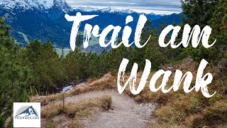
Technical trail on fairly alpine terrain, with various rooty and rocky sections. The main difficulty is the hundreds of wooden water bars that have been added for drainage and steps. These water bars are often right in the middle of the many tight switchbacks, making these more difficult. To ride this whole trail without getting off the bike requires excellent Euro hop/ Nose turn (hinterrad versetzen) skills. Many spots are fun to practice several times.

On sunny weekends when the gondola is running this trail is full of slow hikers.

Access Info

Fireroad to Esterbergalm, then push your bike

Recent Activity on Trail

Past Week
  • 0 rides
  •  
6 Months
  • 0 rides
  •  
All
  • 3 rides
  • Last: Mar 20, 2026
c1c2c3c4
January
February
March
April
May
June
July
August
September
October
November
December
update trails status or condition

Wank from Top Trail Reports

statusdatedescription
Dec 29, 2025 @ 10:48am (Europe/Vaduz)
Dec 29, 2025
Jan 27, 2024 @ 3:54am
Jan 27, 2024
icy and then snowy in the upper half, all clear
Aug 23, 2023 @ 9:04am
Aug 23, 2023
Nov 8, 2021 @ 1:50am
Nov 8, 2021
A little snow in the upper part, then a bit wet, then dry the rest of the way. Completely rideable the whole way.
Jul 2, 2021 @ 11:17pm
Jul 2, 2021
perfect
more »
Status:
on Dec 29, 2025
Icy
Avg: 3.81 (5 votes)
Your vote: 0

view (84)
close
3D
Trail Conditions
  • Unknown
  • Snow Groomed
  • Snow Packed
  • Snow Covered
  • Snow Cover Partial
  • Freeze/thaw Cycle
  • Icy
  • Prevalent Mud
  • Wet
  • Variable
  • Ideal
  • Dry
  • Very Dry
Trail Flow (Ridden Direction)
Trailforks scans users ridelogs to determine the most popular direction each trail is ridden. A good flowing trail network will have most trails flowing in a single direction according to their intension.
The colour categories are based on what percentage of riders are riding a trail in its intended direction.
  • > 96%
  • > 90%
  • > 80%
  • > 70%
  • > 50%
  • < 50%
  • bi-directional trail
  • no data
Trail Last Ridden
Trailforks scans ridelogs to determine the last time a trail was ridden.
  • < 2 days
  • < 1 week
  • < 2 weeks
  • < 1 month
  • < 6 months
  • > 6 months
Trail Ridden Direction
The intended direction a trail should be ridden.
  • Downhill Only
  • Downhill Primary
  • Both Directions
  • Uphill Primary
  • Uphill Only
  • One Direction
Contribute Details
Colors indicate trail is missing specified detail.
  • Description
  • Photos
  • Description & Photos
  • Videos
Trail Popularity ?
Trailforks scans ridelogs to determine which trails are ridden the most in the last 9 months. Trails are compared with nearby trails in the same city region with a possible 25 colour shades. Think of this as a heatmap, more rides = more kinetic energy = warmer colors.
  • most popular
  • popular
  • less popular
  • not popular
ATV/ORV/OHV Filter
Max Vehicle Width
inches
US Cell Coverage
Legend
cell carrier legend

Radar Time
Activity Recordings
Trailforks uses anonymized public activity data. ?
Activity Recordings
Trailforks uses anonymized public activity data. ?
Personal Heatmap
Activity Types
all / none
Options
2
Date range month
Winter Trails
Warning A routing network for winter maps does not exist. Selecting trails using the winter trails layer has been disabled.
Missing Trails
Most Popular
Least Popular
Trails are colored based on popularity. The more popular a trail is, the more red. Less popular trails trend towards green.
Jump Magnitude Heatmap
Heatmap of where riders jump on trails. Zoom in to see individual jumps, click circles to view jump details.
BC Backroad Status

Service Road Atlas is a free to use, community-driven service for viewing and creating reports on the numerous back-country service roads around B.C. and Alberta.

map legend
Slope Aspect
Direction the slope faces
Flat N NE E SE S SW W NW
Trails Deemphasized
Trails are shown in grey.
disable
Only show trails with no bike usage.
Enable
Suggested Layers
Based on selected activity type

    Save the current map location and zoom level as your default home location whenever this page is loaded.

    Save
        Directions to wank-from-top trailhead (47.507970, 11.143330)

        Photos

        3 more »
        144 |
        Mar 9, 2021 @ 8:55am
        Mar 9, 2021
        128 |
        Mar 9, 2021 @ 8:55am
        Mar 9, 2021
        121 |
        Mar 9, 2021 @ 8:55am
        Mar 9, 2021

        Videos

        2 more »
        Wank Trail - Garmisch Partenkirchen
        9:19 | 1179 | Oct 11, 2020 , Garmisch
        MTB Trail Wank
        4:46 | 742 | Nov 29, 2019 , Garmisch

        Reviews / Comments

        No reviews yet, be the first to write a review or ask a question.
        Use trail reports to comment on trail conditions.


        We hope you've been enjoying Trailforks!

        Create a FREE account to view trail comments and much more.

        • By oidaTF Pro & contributors
        • #193068 - 2,308 views

        Frequently Asked Questions About Wank from Top

        Where is Wank from Top located?
        Wank from Top is located in Garmisch Area, Garmisch, Germany. It is part of the Garmisch Area trail network. The trailhead is located at coordinates 47.50797, 11.14333.
        How hard is Wank from Top?
        Wank from Top is rated as Black difficulty. The average grade is 21.9%.
        What is the elevation gain for Wank from Top?
        The trail has 1,919 ft of elevation descent. The elevation ranges from 3,866 ft to 5,785 ft.
        Is Wank from Top a point to point trail?
        Yes, Wank from Top is a point to point trail. The direction is Downhill Only. The trail type is singletrack.

        Hit the Trail

        Open in App

        Get this trail on your phone instantly.
        open trail in app

        Download Trail

        Save to wishlist, Garmin & download.
        save the trail

        Find Related Routes

        Find routes and users activities that include this trail.
        find routes for this trail

        You must enter a description before submitting.