more stats
2.0 miles
Distance
526 ft
Climb
00:19:32
Avg time
526 ft
Altitude change
6,177 ft
Altitude min
6,704 ft
Altitude max
6,177 ft
Altitude start
6,703 ft
Altitude end
4.9%
Grade
-1.4%
Grade max
25.3%
Grade min
2 miles
Distance climb
89 ft
Distance down
79 ft
Distance flat
00:19:32
Avg time

Wapiti Details

  • Activities
    • Mountain Bike
    • Horse
    • Hike
    • Trail Running
  • Riding Area
    Heil Valley Ranch
    Lyons, Colorado
  • Difficulty Rating
  • Voted Difficulty
    Blue (3 votes)
  • Local Popularity
    80 in Mountain Biking [+]
    • 85 in Trail Running
    • 70 in Hiking
    • 5 in Horseback
  • Global Ranking
    #43891 in Mountain Biking [+]
    • #48605 in Trail Running
    • #72165 in Hiking
    • #1246 in Horseback
  • Trail Type
    Singletrack
  • Bike Type
    AM, XC
  • Direction
    Both Directions
  • Climb Difficulty
    Blue
  • Physical Rating
    Moderate
  • Trail Visibility
    Always easy to follow
  • eBike Allowed
  • Land Owner
    Boulder County Parks & Open Space

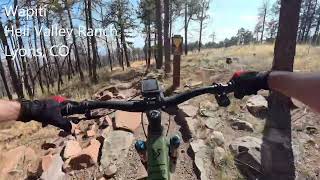
Voted one of the best after-work trails in Boulder County (well, by just one dude who wrote this), and also one of the most filling-removing trails in Boulder County by everyone with a hardtail bike, Wapiti is an action-packed, edge-of-your-seat thrill ride. No, it's not the Lower Bitterbrush over at Hall Ranch. But, yes, it's full of amazing turns, little technical bits, and some amazing Easter eggs (wee little jumpy bits on the edge of the trail). This trail is a fairly steady, but not too steep climb on the way up with a few exciting rock ledges to get up and over. From here you can connect to the Ponderosa Loop and Wild Turkey Trails. On the way down, keep your eyes up and stay in control. This trail is super popular with a variety of crowds (bikes, hikers, and even the equestrians love this trail). On a good day, the downhill is amazing. On a not-so-good day, you'll be stopping to say hello every 30 seconds or so (told ya people like this trail). The surface is a combination of dirt and well-laid out rocks. With a five-inch travel bike (or more) it's a blast. On an XC race by, prepare to have your hands take a beating

Local Trail Association

Recent Activity on Trail

Past Week
  • 4 rides
  • 20 miles average
6 Months
  • 76 rides
  • 17 miles avg distance
All
  • 483 rides
  • Last: Jun 20, 2026
c1c2c3c4
January
February
March
April
May
June
July
August
September
October
November
December
update trails status or condition

Wapiti Trail Reports

statusdatedescription
May 8, 2026 @ 1:20pm (America/Denver)
May 8, 2026
Trail is open. Please update conditions if you ride.
May 2, 2026 @ 5:27pm (America/Denver)
May 2, 2026
Very dry
May 1, 2026 @ 3:20pm (America/Denver)
May 1, 2026
Dec 24, 2025 @ 8:22am (America/Denver)
Dec 24, 2025
Trail is open. Please update conditions if you ride
Dec 18, 2025 @ 9:50pm (America/Denver)
Dec 18, 2025
Trail closed for extreme wind event. Status will be updated when trail reopens
more »
Status:
on May 8, 2026
Avg: 3.6 (19 votes)
Your vote: 0

view (8,241)
close
3D
Trail Conditions
  • Unknown
  • Snow Groomed
  • Snow Packed
  • Snow Covered
  • Snow Cover Partial
  • Freeze/thaw Cycle
  • Icy
  • Prevalent Mud
  • Wet
  • Variable
  • Ideal
  • Dry
  • Very Dry
Trail Flow (Ridden Direction)
Trailforks scans users ridelogs to determine the most popular direction each trail is ridden. A good flowing trail network will have most trails flowing in a single direction according to their intension.
The colour categories are based on what percentage of riders are riding a trail in its intended direction.
  • > 96%
  • > 90%
  • > 80%
  • > 70%
  • > 50%
  • < 50%
  • bi-directional trail
  • no data
Trail Last Ridden
Trailforks scans ridelogs to determine the last time a trail was ridden.
  • < 2 days
  • < 1 week
  • < 2 weeks
  • < 1 month
  • < 6 months
  • > 6 months
Trail Ridden Direction
The intended direction a trail should be ridden.
  • Downhill Only
  • Downhill Primary
  • Both Directions
  • Uphill Primary
  • Uphill Only
  • One Direction
Contribute Details
Colors indicate trail is missing specified detail.
  • Description
  • Photos
  • Description & Photos
  • Videos
Trail Popularity ?
Trailforks scans ridelogs to determine which trails are ridden the most in the last 9 months. Trails are compared with nearby trails in the same city region with a possible 25 colour shades. Think of this as a heatmap, more rides = more kinetic energy = warmer colors.
  • most popular
  • popular
  • less popular
  • not popular
ATV/ORV/OHV Filter
Max Vehicle Width
inches
US Cell Coverage
Legend
cell carrier legend

Radar Time
Activity Recordings
Trailforks uses anonymized public activity data. ?
Activity Recordings
Trailforks uses anonymized public activity data. ?
Personal Heatmap
Activity Types
all / none
Options
2
Date range month
Winter Trails
Warning A routing network for winter maps does not exist. Selecting trails using the winter trails layer has been disabled.
Missing Trails
Most Popular
Least Popular
Trails are colored based on popularity. The more popular a trail is, the more red. Less popular trails trend towards green.
Jump Magnitude Heatmap
Heatmap of where riders jump on trails. Zoom in to see individual jumps, click circles to view jump details.
BC Backroad Status

Service Road Atlas is a free to use, community-driven service for viewing and creating reports on the numerous back-country service roads around B.C. and Alberta.

map legend
Slope Aspect
Direction the slope faces
Flat N NE E SE S SW W NW
Trails Deemphasized
Trails are shown in grey.
disable
Only show trails with no bike usage.
Enable
Suggested Layers
Based on selected activity type

    Save the current map location and zoom level as your default home location whenever this page is loaded.

    Save
        Directions to wapiti-13708 trailhead (40.160470, -105.296580)

        Photos

        11 more »
        617 |
        Jun 4, 2013 @ 10:07pm
        Jun 4, 2013
        38 |
        Apr 11, 2026 @ 12:49pm
        Apr 11, 2026
        21 |
        Apr 11, 2026 @ 12:48pm
        Apr 11, 2026
        101 |
        Apr 24, 2024 @ 9:28pm
        Apr 24, 2024

        Videos

        5 more »
        youtuber Fox DPX2 Review | Full Wapiti Descent at Heil...
        10:17 | 559 | Aug 22, 2017 , Lyons
        Wapiti
        10:54 | 22 | Mar 8, 2026 , Lyons
        Wapiti on my 2009 Project Rockhopper - Heil...
        12:42 | 169 | Sep 12, 2024 , Lyons
        Splish splash Status taking a snow melt bath -...
        8:47 | 104 | Apr 20, 2024 , Lyons

        Routes with this trail

        3.0 8 miles 1,028 ft 4 Out & Back
        A fun ride through the fastest and most technical parts of Heil Ranch. From the main parking lot climb the...
        5.0 12 miles 1,402 ft 6 Loop
        Before the 2020 Calwood Fire, this was a favorite after-work route for the big kids. The post fire...
        Lil' Burrito Featured
        5.0 41 miles 4,953 ft 26 Out & Back
        The Little Burrito (yes, the author knows that "Burrito" is Spanish for little donkey, so this is a...

        4 Reviews & Comments


        We hope you've been enjoying Trailforks!

        Create a FREE account to view trail comments and much more.

        • By toddTF Pro Trailforks & contributors
        • #13708 - 5,028 views

        Frequently Asked Questions About Wapiti

        Where is Wapiti located?
        Wapiti is located in Heil Valley Ranch, Lyons, Colorado, United States. It is part of the Heil Valley Ranch trail network. The trailhead is located at coordinates 40.16047, -105.29658.
        How hard is Wapiti?
        Wapiti is rated as Blue difficulty. The physical rating is Moderate. The average grade is 4.9%. The climb difficulty is rated Blue.
        What is the elevation gain for Wapiti?
        Wapiti has 526 ft of elevation gain. The elevation ranges from 6,177 ft to 6,704 ft.
        Is Wapiti a point to point trail?
        Wapiti is not a point to point trail. The direction is Both Directions. The trail type is singletrack.

        Hit the Trail

        Open in App

        Get this trail on your phone instantly.
        open trail in app

        Download Trail

        Save to wishlist, Garmin & download.
        save the trail

        Find Related Routes

        Find routes and users activities that include this trail.
        find routes for this trail

        You must enter a description before submitting.