more stats
4.3 miles
Distance
16 ft
Climb
-2,490 ft
Descent
00:25:42
Avg time
-2,475 ft
Altitude change
8,241 ft
Altitude min
10,717 ft
Altitude max
10,717 ft
Altitude start
8,241 ft
Altitude end
-10.9%
Grade
-59.3%
Grade max
9%
Grade min
325 ft
Distance climb
4 miles
Distance down
1,070 ft
Distance flat
00:25:42
Avg time

Warren Gulch Details

  • Activities
    • Mountain Bike
    • Hike
    • Trail Running
  • Riding Area
    Idaho Springs
    , Colorado
  • Ref Number
    #47
  • Difficulty Rating
  • Voted Difficulty
    Blue (3 votes)
  • Local Popularity
    75 in Mountain Biking [+]
    • 90 in Trail Running
    • 5 in Hiking
  • Global Ranking
    #57404 in Mountain Biking [+]
    • #762 in Trail Running
    • #120992 in Hiking
  • Hiking SAC Scale
    T1 Hiking
  • Trail Type
    Singletrack
  • Bike Type
    DH, AM
  • Direction
    Downhill Primary
    Popular Direction Shown
  • Climb Difficulty
    Black Diamond
  • Physical Rating
    Hard
  • Dogs Allowed
    Yes
  • eBike Allowed
  • TTFs on Trail
    Berm, Drop, Jump, Rock Garden
  • Land Owner
    Clear Creek Ranger District USFS

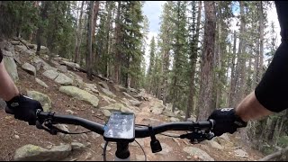
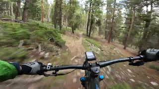
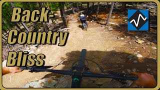
Mostly a shuttle ride although if you are into steep 10+% grade climbing, you can grind your way up. There are rock gardens, tight berm turns, and some steep fast sections. The trail has very little pedaling and with small rocky drops could be classified advanced difficulty for some. The lower half was rerouted in 2021 with more bike optimized trail construction.

Trail Supporters

  • USFS
    Land Manager
Local Trail Association
Traditionally Indigenous Territory

Recent Activity on Trail

Past Week
  • 0 rides
  •  
6 Months
  • 5 rides
  • 9 miles avg distance
All
  • 51 rides
  • Last: Jun 16, 2026
c1c2c3c4
January
February
March
April
May
June
July
August
September
October
November
December
update trails status or condition

Warren Gulch Trail Reports

statusdatedescription
Apr 20, 2026 @ 11:14am (America/Denver)
Apr 20, 2026
Top quarter 4-6in of snow 2nd quarter 0-3in of snow bottom half running perfect
Jul 21, 2024 @ 4:00am
Jul 21, 2024
Jun 23, 2024 @ 6:53am
Jun 23, 2024
Completely clear, running great
Jun 2, 2024 @ 4:55pm
Jun 2, 2024
Snow at the very top 5% of the trail. It's hike-a-bike there. The other 95% is ripping.
Sep 3, 2023 @ 1:49am
Sep 3, 2023
more »
Status:
on Apr 20, 2026
Snow Cover Partial
Avg: 3.79 (9 votes)
Your vote: 0

view (453)
close
3D
Trail Conditions
  • Unknown
  • Snow Groomed
  • Snow Packed
  • Snow Covered
  • Snow Cover Partial
  • Freeze/thaw Cycle
  • Icy
  • Prevalent Mud
  • Wet
  • Variable
  • Ideal
  • Dry
  • Very Dry
Trail Flow (Ridden Direction)
Trailforks scans users ridelogs to determine the most popular direction each trail is ridden. A good flowing trail network will have most trails flowing in a single direction according to their intension.
The colour categories are based on what percentage of riders are riding a trail in its intended direction.
  • > 96%
  • > 90%
  • > 80%
  • > 70%
  • > 50%
  • < 50%
  • bi-directional trail
  • no data
Trail Last Ridden
Trailforks scans ridelogs to determine the last time a trail was ridden.
  • < 2 days
  • < 1 week
  • < 2 weeks
  • < 1 month
  • < 6 months
  • > 6 months
Trail Ridden Direction
The intended direction a trail should be ridden.
  • Downhill Only
  • Downhill Primary
  • Both Directions
  • Uphill Primary
  • Uphill Only
  • One Direction
Contribute Details
Colors indicate trail is missing specified detail.
  • Description
  • Photos
  • Description & Photos
  • Videos
Trail Popularity ?
Trailforks scans ridelogs to determine which trails are ridden the most in the last 9 months. Trails are compared with nearby trails in the same city region with a possible 25 colour shades. Think of this as a heatmap, more rides = more kinetic energy = warmer colors.
  • most popular
  • popular
  • less popular
  • not popular
ATV/ORV/OHV Filter
Max Vehicle Width
inches
US Cell Coverage
Legend
cell carrier legend

Radar Time
Activity Recordings
Trailforks uses anonymized public activity data. ?
Activity Recordings
Trailforks uses anonymized public activity data. ?
Personal Heatmap
Activity Types
all / none
Options
2
Date range month
Winter Trails
Warning A routing network for winter maps does not exist. Selecting trails using the winter trails layer has been disabled.
Missing Trails
Most Popular
Least Popular
Trails are colored based on popularity. The more popular a trail is, the more red. Less popular trails trend towards green.
Jump Magnitude Heatmap
Heatmap of where riders jump on trails. Zoom in to see individual jumps, click circles to view jump details.
BC Backroad Status

Service Road Atlas is a free to use, community-driven service for viewing and creating reports on the numerous back-country service roads around B.C. and Alberta.

map legend
Slope Aspect
Direction the slope faces
Flat N NE E SE S SW W NW
Trails Deemphasized
Trails are shown in grey.
disable
Only show trails with no bike usage.
Enable
Suggested Layers
Based on selected activity type

    Save the current map location and zoom level as your default home location whenever this page is loaded.

    Save
        Directions to warren-gulch trailhead (39.683280, -105.522850)

        Photos

        6 more »
        141 |
        Jul 16, 2024 @ 10:16am
        Jul 16, 2024
        236 |
        Jul 9, 2023 @ 5:31pm
        Jul 9, 2023
        255 |
        Jul 9, 2023 @ 5:27pm
        Jul 9, 2023
        253 |
        Jul 9, 2023 @ 5:25pm
        Jul 9, 2023

        Videos

        4 more »
        Warren Gulch - endurance dark blue at 10,000...
        11:11 | 173 | Sep 17, 2024 , Idaho Springs
        Warren Gulch - Clear Creek County, CO
        15:54 | 204 | Sep 1, 2024 , Idaho Springs
        Warren Gulch MTB Trail | Idaho Springs Colorado
        17:54 | 221 | Jun 3, 2024 , Idaho Springs
        Warren Gulch biking
        2:53 | 1177 | Feb 6, 2018 , Idaho Springs

        13 Reviews & Comments


        We hope you've been enjoying Trailforks!

        Create a FREE account to view trail comments and much more.

        • By toddTF Pro Trailforks & contributors
        • #117493 - 8,889 views

        Frequently Asked Questions About Warren Gulch

        Where is Warren Gulch located?
        Warren Gulch is located in Idaho Springs, Colorado, United States. It is part of the Idaho Springs trail network. The trailhead is located at coordinates 39.68328, -105.52285.
        How hard is Warren Gulch?
        Warren Gulch is rated as Blue difficulty. The physical rating is Hard. The average grade is 10.9%. The climb difficulty is rated Black Diamond.
        What is the elevation gain for Warren Gulch?
        Warren Gulch has 16 ft of elevation gain. The trail has 2,490 ft of elevation descent. The elevation ranges from 8,241 ft to 10,717 ft.
        Is Warren Gulch a point to point trail?
        Warren Gulch is not a point to point trail. The direction is Downhill Primary. The trail type is singletrack.

        Hit the Trail

        Open in App

        Get this trail on your phone instantly.
        open trail in app

        Download Trail

        Save to wishlist, Garmin & download.
        save the trail

        Find Related Routes

        Find routes and users activities that include this trail.
        find routes for this trail

        You must enter a description before submitting.