more stats
2.3 miles
Distance
201 ft
Climb
-1,659 ft
Descent
00:33:42
Avg time
-1,459 ft
Altitude change
11,544 ft
Altitude min
13,065 ft
Altitude max
13,005 ft
Altitude start
11,546 ft
Altitude end
-11.809%
Grade
-40.924%
Grade max
31.504%
Grade min
1,809 ft
Distance climb
2 miles
Distance down
441 ft
Distance flat
00:33:42
Avg time

Wasatch Trail (Upper) Details

  • Activities
    • Mountain Bike
    • Hike
    • Trail Running
  • Riding Area
    Telluride
    , Colorado
  • Ref Number
    #508
  • Difficulty Rating
  • Voted Difficulty
    Double Black Diamond (1 vote)
  • Local Popularity
    50 in Mountain Biking [+]
    • 75 in Trail Running
    • 40 in Hiking
  • Global Ranking
    #94964 in Mountain Biking [+]
    • #72625 in Trail Running
    • #107311 in Hiking
  • Hiking SAC Scale
    T2 Mountain Hiking
  • Trail Type
    Singletrack
  • Bike Type
    AM, XC
  • Direction
    Downhill Primary
  • Climb Difficulty
    Black Diamond
  • Physical Rating
    Hard
  • Alpine Trail
    Yes
  • Dogs Allowed
    Yes
  • TTFs on Trail
    Rock Garden, Skinny

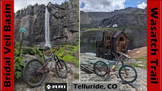
The upper section of the Wasatch Trail through the Bear Creek is a scenic (primarily) descent through scree sections and alpine meadows on single track. The trail varies from buffed smooth and arrow straight to sketchy switchbacks in areas you'll want to avoid falling.

Trail Supporters

  • USFS
    Land Manager
Local Trail Association
Traditionally Indigenous Territory

Recent Activity on Trail

Past Week
  • 0 rides
  •  
6 Months
  • 0 rides
  •  
All
  • 13 rides
  • Last: Jun 18, 2026
c1c2c3c4
January
February
March
April
May
June
July
August
September
October
November
December
update trails status or condition

Wasatch Trail... Trail Reports

statusdatedescription
Jul 11, 2021 @ 9:23am
Jul 11, 2021
Aug 3, 2019 @ 9:43pm
Aug 3, 2019
6 snowfield hike a bike sections exist on trail still
more »
Status:
on Jul 11, 2021
Dry
Avg: 4.21 (3 votes)
Your vote: 0

view (122)
close
3D
Trail Conditions
  • Unknown
  • Snow Groomed
  • Snow Packed
  • Snow Covered
  • Snow Cover Partial
  • Freeze/thaw Cycle
  • Icy
  • Prevalent Mud
  • Wet
  • Variable
  • Ideal
  • Dry
  • Very Dry
Trail Flow (Ridden Direction)
Trailforks scans users ridelogs to determine the most popular direction each trail is ridden. A good flowing trail network will have most trails flowing in a single direction according to their intension.
The colour categories are based on what percentage of riders are riding a trail in its intended direction.
  • > 96%
  • > 90%
  • > 80%
  • > 70%
  • > 50%
  • < 50%
  • bi-directional trail
  • no data
Trail Last Ridden
Trailforks scans ridelogs to determine the last time a trail was ridden.
  • < 2 days
  • < 1 week
  • < 2 weeks
  • < 1 month
  • < 6 months
  • > 6 months
Trail Ridden Direction
The intended direction a trail should be ridden.
  • Downhill Only
  • Downhill Primary
  • Both Directions
  • Uphill Primary
  • Uphill Only
  • One Direction
Contribute Details
Colors indicate trail is missing specified detail.
  • Description
  • Photos
  • Description & Photos
  • Videos
Trail Popularity ?
Trailforks scans ridelogs to determine which trails are ridden the most in the last 9 months. Trails are compared with nearby trails in the same city region with a possible 25 colour shades. Think of this as a heatmap, more rides = more kinetic energy = warmer colors.
  • most popular
  • popular
  • less popular
  • not popular
ATV/ORV/OHV Filter
Max Vehicle Width
inches
US Cell Coverage
Legend
cell carrier legend

Radar Time
Activity Recordings
Trailforks uses anonymized public activity data. ?
Activity Recordings
Trailforks uses anonymized public activity data. ?
Personal Heatmap
Activity Types
all / none
Options
2
Date range month
Winter Trails
Warning A routing network for winter maps does not exist. Selecting trails using the winter trails layer has been disabled.
Missing Trails
Most Popular
Least Popular
Trails are colored based on popularity. The more popular a trail is, the more red. Less popular trails trend towards green.
Jump Magnitude Heatmap
Heatmap of where riders jump on trails. Zoom in to see individual jumps, click circles to view jump details.
BC Backroad Status

Service Road Atlas is a free to use, community-driven service for viewing and creating reports on the numerous back-country service roads around B.C. and Alberta.

map legend
Slope Aspect
Direction the slope faces
Flat N NE E SE S SW W NW
Trails Deemphasized
Trails are shown in grey.
disable
Only show trails with no bike usage.
Enable
Suggested Layers
Based on selected activity type

    Save the current map location and zoom level as your default home location whenever this page is loaded.

    Save
        Directions to wasatch-trail-upper trailhead (37.877170, -107.791290)

        Photos

        6 more »
        38 |
        Aug 1, 2025 @ 9:30am
        Aug 1, 2025
        41 |
        Aug 1, 2025 @ 9:30am
        Aug 1, 2025
        51 |
        Aug 1, 2025 @ 9:29am
        Aug 1, 2025
        164 |
        Aug 18, 2020 @ 8:24am
        Aug 18, 2020

        Videos

        3 more »
        youtuber The AWESOME SPLENDOR of Bridal Veil Basin...
        54:18 | 49 | Aug 1, 2025 , Telluride
        Wasatch Mountain Bike Trail- Part 2 on Youtube
        10:28 | 299 | Sep 10, 2020 , Telluride
        Wasatch Trail in Telluride on Youtube -...
        14:23 | 287 | Sep 10, 2020 , Telluride

        Routes with this trail

        15 miles 4,404 ft 5 Loop
        99 miles 32,109 ft 17 Loop Race
        The Hardrock Hundred Mile Endurance Run is an ultramarathon of 102.5 miles in length, plus 33,197 feet of...

        4 Reviews & Comments


        We hope you've been enjoying Trailforks!

        Create a FREE account to view trail comments and much more.

        • By ultraviolet-catastropheTF Pro & contributors
        • #136944 - 2,274 views

        Frequently Asked Questions About Wasatch Trail (Upper)

        Where is Wasatch Trail (Upper) located?
        Wasatch Trail (Upper) is located in Telluride, Colorado, United States. It is part of the Telluride trail network. The trailhead is located at coordinates 37.87717, -107.79129.
        How hard is Wasatch Trail (Upper)?
        Wasatch Trail (Upper) is rated as Black Diamond difficulty. The physical rating is Hard. The average grade is 11.809%. The climb difficulty is rated Black Diamond.
        What is the elevation gain for Wasatch Trail (Upper)?
        Wasatch Trail (Upper) has 201 ft of elevation gain. The trail has 1,659 ft of elevation descent. The elevation ranges from 11,544 ft to 13,065 ft.
        Is Wasatch Trail (Upper) a point to point trail?
        Wasatch Trail (Upper) is not a point to point trail. The direction is Downhill Primary. The trail type is singletrack.

        Hit the Trail

        Open in App

        Get this trail on your phone instantly.
        open trail in app

        Download Trail

        Save to wishlist, Garmin & download.
        save the trail

        Find Related Routes

        Find routes and users activities that include this trail.
        find routes for this trail

        You must enter a description before submitting.