more stats
1,847 ft
Distance
25 ft
Climb
-225 ft
Descent
00:04:25
Avg time
-199 ft
Altitude change
725 ft
Altitude min
950 ft
Altitude max
950 ft
Altitude start
751 ft
Altitude end
-10.8%
Grade
-36.9%
Grade max
16.5%
Grade min
266 ft
Distance climb
1,214 ft
Distance down
344 ft
Distance flat
00:04:25
Avg time

Watchdog Details

  • Activities
    • Mountain Bike
    • E-Bike
    • Hike
    • Trail Running
  • Riding Area
    Partridge Hills
    Victoria, British Columbia
  • Difficulty Rating
  • Local Popularity
    70 in Mountain Biking [+]
    • 65 in E-Biking
    • 55 in Trail Running
    • 80 in Hiking
  • Global Ranking
    #72588 in Mountain Biking [+]
    • #64068 in E-Biking
    • #99718 in Trail Running
    • #74305 in Hiking
  • Trail Type
    Singletrack
  • Bike Type
    AM, XC
  • Direction
    Downhill Primary
    Popular Direction Shown
  • Physical Rating
    Moderate
  • Dogs Allowed
    Yes
  • eBike Allowed
    Yes up to Class 1
  • TTFs on Trail
    Bridge, Rock Face
  • Land Owner
    BC Parks

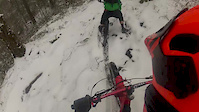
Watchdog descent goes south from the main summit with the top section open with some rock sections. Goes into a wonderful set of 5 berms followed by some flowy trail gnar.

Trail Supporters
Local Trail Association

Recent Activity on Trail

Past Week
  • 1 rides
  • 4 miles average
6 Months
  • 78 rides
  • 6 miles avg distance
All
  • 1,027 rides
  • Last: Jun 16, 2026
c1c2c3c4
January
February
March
April
May
June
July
August
September
October
November
December
update trails status or condition

Watchdog Trail Reports

statusdatedescription
Jan 4, 2026 @ 10:49am (America/Vancouver)
Jan 4, 2026
Nov 30, 2025 @ 12:04pm (America/Vancouver)
Nov 30, 2025
Oct 5, 2025 @ 2:57pm (America/Vancouver)
Oct 5, 2025
Trail running great. Recently received SIMBS trail maintenance removing exposed roots in the bermed switchback corners amongst a bit of other work.
Sep 5, 2025 @ 3:04pm
Sep 5, 2025
Jul 3, 2025 @ 8:54am
Jul 3, 2025
more »
Status:
on Jan 4, 2026
Ideal
Avg: 4.13 (10 votes)
Your vote: 0

view (5,418)
close
3D
Trail Conditions
  • Unknown
  • Snow Groomed
  • Snow Packed
  • Snow Covered
  • Snow Cover Partial
  • Freeze/thaw Cycle
  • Icy
  • Prevalent Mud
  • Wet
  • Variable
  • Ideal
  • Dry
  • Very Dry
Trail Flow (Ridden Direction)
Trailforks scans users ridelogs to determine the most popular direction each trail is ridden. A good flowing trail network will have most trails flowing in a single direction according to their intension.
The colour categories are based on what percentage of riders are riding a trail in its intended direction.
  • > 96%
  • > 90%
  • > 80%
  • > 70%
  • > 50%
  • < 50%
  • bi-directional trail
  • no data
Trail Last Ridden
Trailforks scans ridelogs to determine the last time a trail was ridden.
  • < 2 days
  • < 1 week
  • < 2 weeks
  • < 1 month
  • < 6 months
  • > 6 months
Trail Ridden Direction
The intended direction a trail should be ridden.
  • Downhill Only
  • Downhill Primary
  • Both Directions
  • Uphill Primary
  • Uphill Only
  • One Direction
Contribute Details
Colors indicate trail is missing specified detail.
  • Description
  • Photos
  • Description & Photos
  • Videos
Trail Popularity ?
Trailforks scans ridelogs to determine which trails are ridden the most in the last 9 months. Trails are compared with nearby trails in the same city region with a possible 25 colour shades. Think of this as a heatmap, more rides = more kinetic energy = warmer colors.
  • most popular
  • popular
  • less popular
  • not popular
ATV/ORV/OHV Filter
Max Vehicle Width
inches
US Cell Coverage
Legend
cell carrier legend

Radar Time
Activity Recordings
Trailforks uses anonymized public activity data. ?
Activity Recordings
Trailforks uses anonymized public activity data. ?
Personal Heatmap
Activity Types
all / none
Options
2
Date range month
Winter Trails
Warning A routing network for winter maps does not exist. Selecting trails using the winter trails layer has been disabled.
Missing Trails
Most Popular
Least Popular
Trails are colored based on popularity. The more popular a trail is, the more red. Less popular trails trend towards green.
Jump Magnitude Heatmap
Heatmap of where riders jump on trails. Zoom in to see individual jumps, click circles to view jump details.
BC Backroad Status

Service Road Atlas is a free to use, community-driven service for viewing and creating reports on the numerous back-country service roads around B.C. and Alberta.

map legend
Slope Aspect
Direction the slope faces
Flat N NE E SE S SW W NW
Trails Deemphasized
Trails are shown in grey.
disable
Only show trails with no bike usage.
Enable
Suggested Layers
Based on selected activity type

    Save the current map location and zoom level as your default home location whenever this page is loaded.

    Save
        Directions to watchdog trailhead (48.555080, -123.485220)

        Photos

        6 more »
        126 |
        Mar 30, 2018 @ 5:28pm
        Mar 30, 2018
        386 |
        Feb 3, 2016 @ 9:50am
        Feb 3, 2016
        31 |
        Oct 28, 2024 @ 8:20pm
        Oct 28, 2024
        507 |
        Sep 21, 2015 @ 7:17pm
        Sep 21, 2015

        Videos

        45 more »
        Climbing Watchdog at Partridge Hills in...
        7:49 | 203 | Oct 21, 2023 , Victoria
        180115 Watchdog and Urge
        4:55 | 92 | Jan 16, 2018 , Victoria
        170531 Watchdog Urge
        5:52 | 114 | Jun 1, 2017 , Victoria
        170204 watchdog
        3:57 | 22 | Feb 6, 2017 , Victoria

        Routes with this trail

        21 miles 3,210 ft 37
        Potential route for riding
        18 miles 2,581 ft 36
        Route with no crosses.......................
        22 miles 2,789 ft 39
        Draft route for July 2024

        3 Reviews & Comments


        We hope you've been enjoying Trailforks!

        Create a FREE account to view trail comments and much more.

        • By highrocker1298TF Pro & contributors
        • #7016 - 2,909 views

        Frequently Asked Questions About Watchdog

        Where is Watchdog located?
        Watchdog is located in Partridge Hills, Victoria, British Columbia, Canada. It is part of the Partridge Hills trail network. The trailhead is located at coordinates 48.55508, -123.48522.
        How hard is Watchdog?
        Watchdog is rated as Black Diamond difficulty. The physical rating is Moderate. The average grade is 10.8%.
        What is the elevation gain for Watchdog?
        Watchdog has 8 m of elevation gain. The trail has 69 m of elevation descent. The elevation ranges from 221 m to 290 m.
        Is Watchdog a point to point trail?
        Watchdog is not a point to point trail. The direction is Downhill Primary. The trail type is singletrack.

        Hit the Trail

        Open in App

        Get this trail on your phone instantly.
        open trail in app

        Download Trail

        Save to wishlist, Garmin & download.
        save the trail

        Find Related Routes

        Find routes and users activities that include this trail.
        find routes for this trail

        You must enter a description before submitting.