more stats
1,588 ft
Distance
21 ft
Climb
-224 ft
Descent
00:02:40
Avg time
-203 ft
Altitude change
997 ft
Altitude min
1,222 ft
Altitude max
1,222 ft
Altitude start
1,020 ft
Altitude end
-12.8%
Grade
-43.9%
Grade max
16%
Grade min
240 ft
Distance climb
1,345 ft
Distance down
00:02:40
Avg time

Waterfall Details

  • Activities
    • Mountain Bike
    • E-Bike
    • Hike
    • Trail Running
  • Riding Area
    Mosquito Lake
    Pemberton, British Columbia
  • AKA
    Foxy Lady
  • Difficulty Rating
  • Local Popularity
    90 in Mountain Biking [+]
    • 100 in E-Biking
    • 100 in Trail Running
    • 70 in Hiking
  • Global Ranking
    #40824 in Mountain Biking [+]
    • #4653 in E-Biking
    • #1810 in Trail Running
    • #81632 in Hiking
  • Trail Type
    Singletrack
  • Direction
    Downhill Only
    Popular Direction Shown
  • Dogs Allowed
    Yes
  • eBike Allowed
    Yes up to Class 1

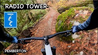
Short-ish intermediate trail with a good mix of terrain. Some rooty rocky chunk followed by some nice corners and flow with a few small table top jumps before joining up with Cross Town Trafic.

Access Info

Take a left at the end of Dark Forest, or continue straight at the junction when coming down Radio Tower.

Local Trail Association
Traditionally Indigenous Territory

Recent Activity on Trail

Past Week
  • 5 rides
  • 6 miles average
6 Months
  • 70 rides
  • 8 miles avg distance
All
  • 855 rides
  • Last: Jun 17, 2026
c1c2c3c4
January
February
March
April
May
June
July
August
September
October
November
December
Status:
on Jun 11, 2026
Dry
Avg: 4.14 (8 votes)
Your vote: 0

view (5,199)
close
3D
Trail Conditions
  • Unknown
  • Snow Groomed
  • Snow Packed
  • Snow Covered
  • Snow Cover Partial
  • Freeze/thaw Cycle
  • Icy
  • Prevalent Mud
  • Wet
  • Variable
  • Ideal
  • Dry
  • Very Dry
Trail Flow (Ridden Direction)
Trailforks scans users ridelogs to determine the most popular direction each trail is ridden. A good flowing trail network will have most trails flowing in a single direction according to their intension.
The colour categories are based on what percentage of riders are riding a trail in its intended direction.
  • > 96%
  • > 90%
  • > 80%
  • > 70%
  • > 50%
  • < 50%
  • bi-directional trail
  • no data
Trail Last Ridden
Trailforks scans ridelogs to determine the last time a trail was ridden.
  • < 2 days
  • < 1 week
  • < 2 weeks
  • < 1 month
  • < 6 months
  • > 6 months
Trail Ridden Direction
The intended direction a trail should be ridden.
  • Downhill Only
  • Downhill Primary
  • Both Directions
  • Uphill Primary
  • Uphill Only
  • One Direction
Contribute Details
Colors indicate trail is missing specified detail.
  • Description
  • Photos
  • Description & Photos
  • Videos
Trail Popularity ?
Trailforks scans ridelogs to determine which trails are ridden the most in the last 9 months. Trails are compared with nearby trails in the same city region with a possible 25 colour shades. Think of this as a heatmap, more rides = more kinetic energy = warmer colors.
  • most popular
  • popular
  • less popular
  • not popular
ATV/ORV/OHV Filter
Max Vehicle Width
inches
US Cell Coverage
Legend
cell carrier legend

Radar Time
Activity Recordings
Trailforks uses anonymized public activity data. ?
Activity Recordings
Trailforks uses anonymized public activity data. ?
Personal Heatmap
Activity Types
all / none
Options
2
Date range month
Winter Trails
Warning A routing network for winter maps does not exist. Selecting trails using the winter trails layer has been disabled.
Missing Trails
Most Popular
Least Popular
Trails are colored based on popularity. The more popular a trail is, the more red. Less popular trails trend towards green.
Jump Magnitude Heatmap
Heatmap of where riders jump on trails. Zoom in to see individual jumps, click circles to view jump details.
BC Backroad Status

Service Road Atlas is a free to use, community-driven service for viewing and creating reports on the numerous back-country service roads around B.C. and Alberta.

map legend
Slope Aspect
Direction the slope faces
Flat N NE E SE S SW W NW
Trails Deemphasized
Trails are shown in grey.
disable
Only show trails with no bike usage.
Enable
Suggested Layers
Based on selected activity type

    Save the current map location and zoom level as your default home location whenever this page is loaded.

    Save
        Directions to waterfall-53254 trailhead (50.327160, -122.754820)

        Photos

        16 more »
        590 |
        May 6, 2016 @ 8:35am
        May 6, 2016
        623 |
        May 6, 2016 @ 8:37am
        May 6, 2016
        55 |
        Mar 24, 2020 @ 11:33pm
        Mar 24, 2020
        103 |
        Apr 11, 2019 @ 12:38am
        Apr 11, 2019

        Videos

        4 more »
        RADIO TOWER | Blue trail | Pemberton
        4:54 | 117 | Nov 28, 2023 , Pemberton
        20% Of My Body Weight Gone, 2 New MTBs And...
        12:00 | 121 | Apr 1, 2023 , Pemberton
        The best kids lap in Pemberton?
        8:57 | 247 | Mar 23, 2021 , Pemberton
        Back Pains to Radio Tower and Waterfall
        9:35 | 288 | Sep 1, 2020 , Pemberton

        Routes with this trail

        16 miles 3,448 ft 18
        The Pemberton Off-Road Cycling Association (PORCA) presents the Spud Crusher Women’s Enduro - back from...
        4 miles 1,198 ft 6
        Sign In Time: 5:30 PM Sign In Location: Mackenzie FSR Lot Start Time: 6:00 PM Après: at HWY Cafe
        3.0 18 miles 4,659 ft 35
        The 2018 Pemberton Enduro course offers up an excellent variety of Pemberton's trail styles and is...

        Trail Products

        1 Review & Comments


        We hope you've been enjoying Trailforks!

        Create a FREE account to view trail comments and much more.

        • By BCpovTF Pro & contributors
        • #53254 - 3,872 views

        Frequently Asked Questions About Waterfall

        Where is Waterfall located?
        Waterfall is located in Mosquito Lake, Pemberton, British Columbia, Canada. It is part of the Mosquito Lake trail network. The trailhead is located at coordinates 50.32716, -122.75482.
        How hard is Waterfall?
        Waterfall is rated as Blue difficulty. The average grade is 12.8%.
        What is the elevation gain for Waterfall?
        Waterfall has 21 ft of elevation gain. The trail has 224 ft of elevation descent. The elevation ranges from 997 ft to 1,222 ft.
        Is Waterfall a point to point trail?
        Yes, Waterfall is a point to point trail. The direction is Downhill Only. The trail type is singletrack.

        Hit the Trail

        Open in App

        Get this trail on your phone instantly.
        open trail in app

        Download Trail

        Save to wishlist, Garmin & download.
        save the trail

        Find Related Routes

        Find routes and users activities that include this trail.
        find routes for this trail

        You must enter a description before submitting.