

Open in App
Get this trail on your phone instantly.

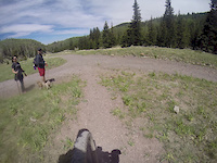
A gravel road that traverses the San Francisco Peaks and offers great views. Also is a Forest Service access road, but only for emergencies. Most of the road and surrounding area was burned by the 2010 Schultz Fire. About 1/5 the way up the road(Lower segment) there is a rock spire tunnel. At about 4/5 the way up the road, the Schultz Fire burn scar stops and you enter towering mixed conifer forests and aspen groves. This road makes for excellent gravel riding since it is closed to motorized traffic. Runner and bikers alike use this route for elevation training as well.
| c1 | c2 | c3 | c4 |
|---|---|---|---|
January | February | March | April |
May | June | July | August |
September | October | November | December |

Service Road Atlas is a free to use, community-driven service for viewing and creating reports on the numerous back-country service roads around B.C. and Alberta.
Save the current map location and zoom level as your default home location whenever this page is loaded.
SaveWe hope you've been enjoying Trailforks!
Create a FREE account to view trail comments and much more.
You must enter a description before submitting.

