more stats
1.2 miles
Distance
-741 ft
Descent
00:06:51
Avg time
-741 ft
Altitude change
1,368 ft
Altitude min
2,109 ft
Altitude max
2,109 ft
Altitude start
1,368 ft
Altitude end
-11.8%
Grade
-38.5%
Grade max
2%
Grade min
102 ft
Distance climb
1 mile
Distance down
00:06:51
Avg time

Webb Canyon Details

  • Activities
    • Mountain Bike
    • E-Bike
    • Hike
  • Riding Area
    La Verne
    , California
  • Difficulty Rating
  • Voted Difficulty
    Blue (5 votes)
  • Local Popularity
    25 in Mountain Biking [+]
    • 100 in E-Biking
    • 20 in Hiking
  • Global Ranking
    #102301 in Mountain Biking [+]
    • #3131 in E-Biking
    • #114712 in Hiking
  • Hiking SAC Scale
    T1 Hiking
  • Trail Type
    Singletrack
  • Bike Type
    DH, AM
  • Direction
    Downhill Only
    Popular Direction Shown
  • Physical Rating
    Moderate
  • Dogs Allowed
    Yes
  • eBike Allowed
    Yes up to Class 1
  • TTFs on Trail
    Berm, Drop, Jump, Gap Jump, Rock Garden

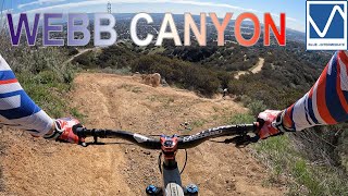
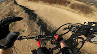
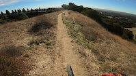
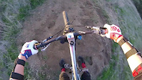
A true downhill trail including berms, rock gardens, chutes, modest drops, doubles, kickers, etc. At times chunky, at times flowy, and always fun.

Access Info Restricted Access

Access via a short climb up Johnson Pasture from the end of Via Santa Catarina then taking the spur climb to your left to the top of the trail (or by descending Johnson pasture, then the climb to the top is on your right).

The trail technically is on private land and ends into a church parking lot (you can typically exit by crossing the parking lot kindly and slowly).

This trail is unsanctioned.

Traditionally Indigenous Territory

Recent Activity on Trail

Past Week
  • 1 rides
  • 19 miles average
6 Months
  • 4 rides
  • 12 miles avg distance
All
  • 53 rides
  • Last: Jun 13, 2026
c1c2c3c4
January
February
March
April
May
June
July
August
September
October
November
December
update trails status or condition

Webb Canyon Trail Reports

statusdatedescription
Oct 16, 2025 @ 3:34pm (America/Los_Angeles)
Oct 16, 2025
Aug 22, 2023 @ 6:47pm
Aug 22, 2023
completely rutted out after Hilary. none of the jumps are hittable. needs a ton of work
Jun 30, 2023 @ 12:42pm
Jun 30, 2023
A tad overgrown in spots and definitely more rutty and rowdy after the rainy winter, but running pretty well otherwise.
Oct 30, 2021 @ 3:00pm
Oct 30, 2021
Oct 2, 2021 @ 10:57am
Oct 2, 2021
Dry loose chunky brake bumps throughout a bit worn jumps are in preferred condition..fun
more »
Status:
on Nov 25, 2025
Avg: 4.26 (9 votes)
Your vote: 0

view (1,176)
close
3D
Trail Conditions
  • Unknown
  • Snow Groomed
  • Snow Packed
  • Snow Covered
  • Snow Cover Partial
  • Freeze/thaw Cycle
  • Icy
  • Prevalent Mud
  • Wet
  • Variable
  • Ideal
  • Dry
  • Very Dry
Trail Flow (Ridden Direction)
Trailforks scans users ridelogs to determine the most popular direction each trail is ridden. A good flowing trail network will have most trails flowing in a single direction according to their intension.
The colour categories are based on what percentage of riders are riding a trail in its intended direction.
  • > 96%
  • > 90%
  • > 80%
  • > 70%
  • > 50%
  • < 50%
  • bi-directional trail
  • no data
Trail Last Ridden
Trailforks scans ridelogs to determine the last time a trail was ridden.
  • < 2 days
  • < 1 week
  • < 2 weeks
  • < 1 month
  • < 6 months
  • > 6 months
Trail Ridden Direction
The intended direction a trail should be ridden.
  • Downhill Only
  • Downhill Primary
  • Both Directions
  • Uphill Primary
  • Uphill Only
  • One Direction
Contribute Details
Colors indicate trail is missing specified detail.
  • Description
  • Photos
  • Description & Photos
  • Videos
Trail Popularity ?
Trailforks scans ridelogs to determine which trails are ridden the most in the last 9 months. Trails are compared with nearby trails in the same city region with a possible 25 colour shades. Think of this as a heatmap, more rides = more kinetic energy = warmer colors.
  • most popular
  • popular
  • less popular
  • not popular
ATV/ORV/OHV Filter
Max Vehicle Width
inches
US Cell Coverage
Legend
cell carrier legend

Radar Time
Activity Recordings
Trailforks uses anonymized public activity data. ?
Activity Recordings
Trailforks uses anonymized public activity data. ?
Personal Heatmap
Activity Types
all / none
Options
2
Date range month
Winter Trails
Warning A routing network for winter maps does not exist. Selecting trails using the winter trails layer has been disabled.
Missing Trails
Most Popular
Least Popular
Trails are colored based on popularity. The more popular a trail is, the more red. Less popular trails trend towards green.
Jump Magnitude Heatmap
Heatmap of where riders jump on trails. Zoom in to see individual jumps, click circles to view jump details.
BC Backroad Status

Service Road Atlas is a free to use, community-driven service for viewing and creating reports on the numerous back-country service roads around B.C. and Alberta.

map legend
Slope Aspect
Direction the slope faces
Flat N NE E SE S SW W NW
Trails Deemphasized
Trails are shown in grey.
disable
Only show trails with no bike usage.
Enable
Suggested Layers
Based on selected activity type

    Save the current map location and zoom level as your default home location whenever this page is loaded.

    Save
        Directions to webb-canyon trailhead (34.140840, -117.730530)

        Photos

        123 more »
        524 |
        Feb 16, 2018 @ 12:39pm
        Feb 16, 2018
        1,477 |
        Oct 3, 2016 @ 12:57pm
        Oct 3, 2016
        970 |
        Sep 30, 2016 @ 3:01pm
        Sep 30, 2016
        168 |
        Dec 19, 2015 @ 9:18pm
        Dec 19, 2015

        Videos

        93 more »
        Webb Canyon - San Bernardino - Claremont
        5:04 | 369 | Feb 22, 2022 , La Verne
        Webb Canyon
        0:45 | 102 | Mar 15, 2021 , La Verne
        Webb Canyon
        2:24 | 283 | Jan 16, 2021 , La Verne
        Lil' Booter
        0:16 | 392 | Oct 9, 2018 , La Verne

        5 Reviews & Comments


        We hope you've been enjoying Trailforks!

        Create a FREE account to view trail comments and much more.

        • #23418 - 13,241 views

        Frequently Asked Questions About Webb Canyon

        Where is Webb Canyon located?
        Webb Canyon is located in La Verne, California, United States. It is part of the La Verne trail network. The trailhead is located at coordinates 34.14084, -117.73053.
        How hard is Webb Canyon?
        Webb Canyon is rated as Black Diamond difficulty. The physical rating is Moderate. The average grade is 11.8%.
        What is the elevation gain for Webb Canyon?
        The trail has 741 ft of elevation descent. The elevation ranges from 1,368 ft to 2,109 ft.
        Is Webb Canyon a point to point trail?
        Yes, Webb Canyon is a point to point trail. The direction is Downhill Only. The trail type is singletrack.

        Hit the Trail

        Open in App

        Get this trail on your phone instantly.
        open trail in app

        Download Trail

        Save to wishlist, Garmin & download.
        save the trail

        Find Related Routes

        Find routes and users activities that include this trail.
        find routes for this trail

        You must enter a description before submitting.