more stats
3,691 ft
Distance
21 ft
Climb
-414 ft
Descent
00:08:32
Avg time
-392 ft
Altitude change
1,876 ft
Altitude min
2,291 ft
Altitude max
2,269 ft
Altitude start
1,877 ft
Altitude end
-10.6%
Grade
-62.4%
Grade max
14.6%
Grade min
541 ft
Distance climb
2,956 ft
Distance down
194 ft
Distance flat
00:08:32
Avg time

Wedding Crashers Details

  • Activities
    • Mountain Bike
    • E-Bike
    • Hike
    • Trail Running
  • Riding Area
    Three Blind Mice
    Penticton, British Columbia
  • AKA
    Tie The Knot
  • Difficulty Rating
  • Local Popularity
    85 in Mountain Biking [+]
    • 65 in E-Biking
    • 65 in Trail Running
    • 80 in Hiking
  • Global Ranking
    #71429 in Mountain Biking [+]
    • #70646 in E-Biking
    • #95667 in Trail Running
    • #99520 in Hiking
  • Trail Type
    Singletrack
  • Bike Type
    AM, XC
  • Climb Difficulty
    Black Diamond
  • Physical Rating
    Hard
  • Season
    March-December
  • Dogs Allowed
    Yes
  • eBike Allowed
    Yes up to Class 1
  • TTFs on Trail
    Drop, Rock Face

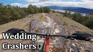
Wedding Crashers is more of a free-ride area than a trail. There are 'no-go' lines that will result in catastrophe but it is cairned out so navigation should be manageable.
Originally created and left un-named, it was re-discovered by some soon-to-be-wedded bikers who were going to get married on a trail at the bottom. Friends joked they would come ripping down and crash the wedding, so the trail was aptly named.
They have since attempted to re-name it Tie The Knot, but it will forever be written as Wedding Crashers. Mwuhahahahahaha.
The terrain is rock, rock, rock.

There are some that chose to climb it, we judge them.

Access Info

Skull will come to a 4 way intersection with Hills Hills, carry up the hill past the 'Tie The Knot' sign.

Local Trail Association

Recent Activity on Trail

Past Week
  • 1 rides
  • 11 miles average
6 Months
  • 19 rides
  • 12 miles avg distance
All
  • 212 rides
  • Last: Jun 15, 2026
c1c2c3c4
January
February
March
April
May
June
July
August
September
October
November
December
update trails status or condition

Wedding Crashers Trail Reports

Status:
on Apr 24, 2026
Ideal
Avg: 3.93 (10 votes)
Your vote: 0

view (1,353)
close
3D
Trail Conditions
  • Unknown
  • Snow Groomed
  • Snow Packed
  • Snow Covered
  • Snow Cover Partial
  • Freeze/thaw Cycle
  • Icy
  • Prevalent Mud
  • Wet
  • Variable
  • Ideal
  • Dry
  • Very Dry
Trail Flow (Ridden Direction)
Trailforks scans users ridelogs to determine the most popular direction each trail is ridden. A good flowing trail network will have most trails flowing in a single direction according to their intension.
The colour categories are based on what percentage of riders are riding a trail in its intended direction.
  • > 96%
  • > 90%
  • > 80%
  • > 70%
  • > 50%
  • < 50%
  • bi-directional trail
  • no data
Trail Last Ridden
Trailforks scans ridelogs to determine the last time a trail was ridden.
  • < 2 days
  • < 1 week
  • < 2 weeks
  • < 1 month
  • < 6 months
  • > 6 months
Trail Ridden Direction
The intended direction a trail should be ridden.
  • Downhill Only
  • Downhill Primary
  • Both Directions
  • Uphill Primary
  • Uphill Only
  • One Direction
Contribute Details
Colors indicate trail is missing specified detail.
  • Description
  • Photos
  • Description & Photos
  • Videos
Trail Popularity ?
Trailforks scans ridelogs to determine which trails are ridden the most in the last 9 months. Trails are compared with nearby trails in the same city region with a possible 25 colour shades. Think of this as a heatmap, more rides = more kinetic energy = warmer colors.
  • most popular
  • popular
  • less popular
  • not popular
ATV/ORV/OHV Filter
Max Vehicle Width
inches
US Cell Coverage
Legend
cell carrier legend

Radar Time
Activity Recordings
Trailforks uses anonymized public activity data. ?
Activity Recordings
Trailforks uses anonymized public activity data. ?
Personal Heatmap
Activity Types
all / none
Options
2
Date range month
Winter Trails
Warning A routing network for winter maps does not exist. Selecting trails using the winter trails layer has been disabled.
Missing Trails
Most Popular
Least Popular
Trails are colored based on popularity. The more popular a trail is, the more red. Less popular trails trend towards green.
Jump Magnitude Heatmap
Heatmap of where riders jump on trails. Zoom in to see individual jumps, click circles to view jump details.
BC Backroad Status

Service Road Atlas is a free to use, community-driven service for viewing and creating reports on the numerous back-country service roads around B.C. and Alberta.

map legend
Slope Aspect
Direction the slope faces
Flat N NE E SE S SW W NW
Trails Deemphasized
Trails are shown in grey.
disable
Only show trails with no bike usage.
Enable
Suggested Layers
Based on selected activity type

    Save the current map location and zoom level as your default home location whenever this page is loaded.

    Save
        Directions to wedding-crashers trailhead (49.556170, -119.552720)

        Photos

        8 more »
        71 |
        Jul 6, 2021 @ 12:21pm
        Jul 6, 2021
        125 |
        Aug 26, 2020 @ 5:09pm
        Aug 26, 2020
        147 |
        Sep 9, 2019 @ 10:13am
        Sep 9, 2019
        159 |
        Sep 9, 2019 @ 10:13am
        Sep 9, 2019

        Videos

        7 more »
        youtuber Wedding Crashers Three Blind Mice Penticton
        2:12 | 801 | May 18, 2018 , Penticton
        Penticton Perfection : Riding The Best MTB...
        30:38 | 60 | Apr 7, 2025 , Penticton
        Slabs With Line Choice | Wedding Crashers -...
        4:19 | 136 | Oct 5, 2024 , Penticton
        Wedding Crashers, Three Blind Mice, Penticton.
        671 | Sep 17, 2017 , Penticton

        Routes with this trail

        11 miles 1,069 ft 10
        Three Blind Mice is big enough for two official Backyard Ride Guide's, so that's exactly what it gets!...
        18 miles 3,032 ft 5
        Not yet tested. Will add comment after ridden. Rode it but it goes off the rails a few times due to...
        3 miles 706 ft 4
        Short on time and need a quick one? Have a hankering for some and flow? Ride both “Coasters” in the...

        Trail Products

        3 Reviews & Comments


        We hope you've been enjoying Trailforks!

        Create a FREE account to view trail comments and much more.

        • By 1partatatimeTF Pro PACA & contributors
        • #28066 - 3,227 views

        Frequently Asked Questions About Wedding Crashers

        Where is Wedding Crashers located?
        Wedding Crashers is located in Three Blind Mice, Penticton, British Columbia, Canada. It is part of the Three Blind Mice trail network. The trailhead is located at coordinates 49.55617, -119.55272.
        How hard is Wedding Crashers?
        Wedding Crashers is rated as Black Diamond difficulty. The physical rating is Hard. The average grade is 10.6%. The climb difficulty is rated Black Diamond.
        What is the elevation gain for Wedding Crashers?
        Wedding Crashers has 21 ft of elevation gain. The trail has 414 ft of elevation descent. The elevation ranges from 1,876 ft to 2,291 ft.
        How long is Wedding Crashers?
        Wedding Crashers is 3,691 ft long. The trail type is singletrack.

        Hit the Trail

        Open in App

        Get this trail on your phone instantly.
        open trail in app

        Download Trail

        Save to wishlist, Garmin & download.
        save the trail

        Find Related Routes

        Find routes and users activities that include this trail.
        find routes for this trail

        You must enter a description before submitting.