more stats
5.0 miles
Distance
17 ft
Climb
-1,658 ft
Descent
00:43:44
Avg time
-1,641 ft
Altitude change
10,028 ft
Altitude min
11,669 ft
Altitude max
11,669 ft
Altitude start
10,026 ft
Altitude end
-6.2%
Grade
-57.4%
Grade max
15.1%
Grade min
207 ft
Distance climb
5 miles
Distance down
564 ft
Distance flat
00:43:44
Avg time

West Jefferson Details

  • Activities
    • Mountain Bike
    • Hike
    • Trail Running
  • Riding Area
    Park County
    Breckenridge, Colorado
  • Ref Number
    #643
  • Difficulty Rating
  • Voted Difficulty
    Blue (3 votes)
  • Local Popularity
    65 in Mountain Biking [+]
    • 5 in Trail Running
    • 75 in Hiking
  • Global Ranking
    #79863 in Mountain Biking [+]
    • #137357 in Trail Running
    • #72735 in Hiking
  • Hiking SAC Scale
    T1 Hiking
  • Trail Type
    Singletrack
  • Direction
    Both Directions
    Popular In Reverse
  • Climb Difficulty
    Black Diamond
  • Physical Rating
    Hard
  • Dogs Allowed
    Yes
  • eBike Allowed

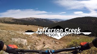
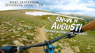
A raw, tight, technical trail that starts off of Kenosha pass and the Colorado Trail. Expect a few hundred yards of narrow, flowy singletrack at the beginning that drops into rocky, chunky terrain with a few creek crossings. Nothing crazy steep or crazy technical but definitely raw and rocky. Make sure your switchback game is on point as there are quite a few very tight corners to navigate. Also keep an eye out for downed trees as there can be a lot of them and they come up fast. Trail was maintained in 2024 and switchbacks were optimized for bikes.

Trail Supporters

  • USFS
    Land Manager
Local Trail Association
Traditionally Indigenous Territory

Recent Activity on Trail

Past Week
  • 0 rides
  •  
6 Months
  • 1 rides
  • 37 miles avg distance
All
  • 75 rides
  • Last: Jun 6, 2026
c1c2c3c4
January
February
March
April
May
June
July
August
September
October
November
December
update trails status or condition

West Jefferson Trail Reports

statusdatedescription
Jun 12, 2026 @ 7:33am (America/Denver)
Jun 12, 2026
reporter I heard reports of many trees down
Sep 27, 2025 @ 9:56pm (America/Denver)
Sep 27, 2025
One tree down
Jul 19, 2025 @ 7:46pm
Jul 19, 2025
All clear
Jun 12, 2025 @ 3:20pm
Jun 12, 2025
Unrideable due to patchy deep snow above 11,100.
Jul 23, 2024 @ 9:03am
Jul 23, 2024
Downed trees all cleared
more »
Status:
on Jun 12, 2026
Variable
Avg: 4.11 (11 votes)
Your vote: 0

view (865)
close
3D
Trail Conditions
  • Unknown
  • Snow Groomed
  • Snow Packed
  • Snow Covered
  • Snow Cover Partial
  • Freeze/thaw Cycle
  • Icy
  • Prevalent Mud
  • Wet
  • Variable
  • Ideal
  • Dry
  • Very Dry
Trail Flow (Ridden Direction)
Trailforks scans users ridelogs to determine the most popular direction each trail is ridden. A good flowing trail network will have most trails flowing in a single direction according to their intension.
The colour categories are based on what percentage of riders are riding a trail in its intended direction.
  • > 96%
  • > 90%
  • > 80%
  • > 70%
  • > 50%
  • < 50%
  • bi-directional trail
  • no data
Trail Last Ridden
Trailforks scans ridelogs to determine the last time a trail was ridden.
  • < 2 days
  • < 1 week
  • < 2 weeks
  • < 1 month
  • < 6 months
  • > 6 months
Trail Ridden Direction
The intended direction a trail should be ridden.
  • Downhill Only
  • Downhill Primary
  • Both Directions
  • Uphill Primary
  • Uphill Only
  • One Direction
Contribute Details
Colors indicate trail is missing specified detail.
  • Description
  • Photos
  • Description & Photos
  • Videos
Trail Popularity ?
Trailforks scans ridelogs to determine which trails are ridden the most in the last 9 months. Trails are compared with nearby trails in the same city region with a possible 25 colour shades. Think of this as a heatmap, more rides = more kinetic energy = warmer colors.
  • most popular
  • popular
  • less popular
  • not popular
ATV/ORV/OHV Filter
Max Vehicle Width
inches
US Cell Coverage
Legend
cell carrier legend

Radar Time
Activity Recordings
Trailforks uses anonymized public activity data. ?
Activity Recordings
Trailforks uses anonymized public activity data. ?
Personal Heatmap
Activity Types
all / none
Options
2
Date range month
Winter Trails
Warning A routing network for winter maps does not exist. Selecting trails using the winter trails layer has been disabled.
Missing Trails
Most Popular
Least Popular
Trails are colored based on popularity. The more popular a trail is, the more red. Less popular trails trend towards green.
Jump Magnitude Heatmap
Heatmap of where riders jump on trails. Zoom in to see individual jumps, click circles to view jump details.
BC Backroad Status

Service Road Atlas is a free to use, community-driven service for viewing and creating reports on the numerous back-country service roads around B.C. and Alberta.

map legend
Slope Aspect
Direction the slope faces
Flat N NE E SE S SW W NW
Trails Deemphasized
Trails are shown in grey.
disable
Only show trails with no bike usage.
Enable
Suggested Layers
Based on selected activity type

    Save the current map location and zoom level as your default home location whenever this page is loaded.

    Save
        Directions to west-jefferson trailhead (39.454060, -105.902300)

        Photos

        5 more »
        260 |
        Jun 29, 2016 @ 5:22pm
        Jun 29, 2016
        236 |
        Jun 29, 2016 @ 5:22pm
        Jun 29, 2016
        334 |
        Jun 29, 2016 @ 5:22pm
        Jun 29, 2016
        248 |
        Jun 29, 2016 @ 5:23pm
        Jun 29, 2016

        Videos

        3 more »
        youtuber Best Downhill In Colorado :||: Mountain Biking...
        886 | Oct 11, 2017 , Breckenridge
        Kenosha Pass to West Jefferson | Mountain...
        11:26 | 343 | Sep 17, 2020 , Breckenridge
        upper jefferson creek
        0:17 | 132 | Aug 7, 2010 , Breckenridge

        Routes with this trail

        5.0 22 miles 3,219 ft 4 Loop
        Awesome high alpine loop going up to 11,800ft
        10 miles 1,689 ft 1 Loop
        very close to Jefferson lake and Jefferson creek and lodge poll campgrounds this loop goes ~5 miles up the...

        5 Reviews & Comments


        We hope you've been enjoying Trailforks!

        Create a FREE account to view trail comments and much more.

        • By toddTF Pro Trailforks & contributors
        • #13429 - 3,653 views

        Frequently Asked Questions About West Jefferson

        Where is West Jefferson located?
        West Jefferson is located in Park County, Breckenridge, Colorado, United States. It is part of the Park County trail network. The trailhead is located at coordinates 39.45406, -105.9023.
        How hard is West Jefferson?
        West Jefferson is rated as Blue difficulty. The physical rating is Hard. The average grade is 6.2%. The climb difficulty is rated Black Diamond.
        What is the elevation gain for West Jefferson?
        West Jefferson has 17 ft of elevation gain. The trail has 1,658 ft of elevation descent. The elevation ranges from 10,028 ft to 11,669 ft.
        Is West Jefferson a point to point trail?
        West Jefferson is not a point to point trail. The direction is Both Directions. The trail type is singletrack.

        Hit the Trail

        Open in App

        Get this trail on your phone instantly.
        open trail in app

        Download Trail

        Save to wishlist, Garmin & download.
        save the trail

        Find Related Routes

        Find routes and users activities that include this trail.
        find routes for this trail

        You must enter a description before submitting.