more stats
9.7 miles
Distance
1,844 ft
Climb
-2,039 ft
Descent
01:56:29
Avg time
-195 ft
Altitude change
1,566 ft
Altitude min
2,478 ft
Altitude max
1,765 ft
Altitude start
1,572 ft
Altitude end
-0.4%
Grade
-32.7%
Grade max
43.3%
Grade min
4 miles
Distance climb
5 miles
Distance down
2,536 ft
Distance flat
01:56:29
Avg time

Wharfedale Track Details

  • Activities
    • Mountain Bike
    • Hike
    • Trail Running
  • Riding Area
  • Difficulty Rating
  • Voted Difficulty
    Blue (1 vote)
  • Local Popularity
    35 in Mountain Biking [+]
    • 5 in Trail Running
    • 80 in Hiking
  • Global Ranking
    #54546 in Mountain Biking [+]
    • #111569 in Trail Running
    • #1322 in Hiking
  • Trail Type
    Singletrack
  • Bike Type
    AM, XC
  • Climb Difficulty
    Blue
  • Physical Rating
    Moderate
  • Dogs Allowed
    Yes
  • Land Owner

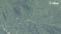
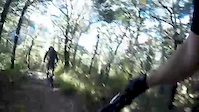
This is an old stock route formed in 1879. It's overall gradient is generally okay, but as the weather takes its toll, the track has been weathered into a fun mountain bike track with exposed roots, fords and plenty of rocks. From the car park, follow the trail through beech forest to the saddle approx. 2 hours away. Turn around here and head back for a mostly downhill run at a good Intermediate grade ride. Or, continue on to and beyond the Wharfedale Hut for a much tougher (with some walking) ride (about 5 hours return).

NB: The Wharfedale is a grade harder when wet.

Access Info

From Oxford, drive south-west (towards Arthur's Pass) for just over 3km and turn right onto Woodstock Rd at the 'View Hill' signpost. Drive down the road for 10km before turning right onto Ingrams Rd at the 'Wharfedale Track' sign and cruising down to the ford 1 km away. If it has been raining you'll have to park here, otherwise continue up to the car park a further 6km away.

Traditionally Indigenous Territory

Recent Activity on Trail

Past Week
  • 0 rides
  •  
6 Months
  • 7 rides
  • 23 miles avg distance
All
  • 50 rides
  • Last: Jun 7, 2026
c1c2c3c4
January
February
March
April
May
June
July
August
September
October
November
December
update trails status or condition

Wharfedale Track Trail Reports

statusdatedescription
Apr 11, 2026 @ 8:27pm (Pacific/Auckland)
Apr 11, 2026
The best it’s been in decades really, thanks to the great job by Scott and Jim. All the usual wet spots and lots of blocked scupper drains after...
Feb 23, 2026 @ 12:37pm (Pacific/Auckland)
Feb 22, 2026
Track clear muddy in sections but nothing too bad.
Feb 8, 2026 @ 9:45am (Pacific/Auckland)
Feb 7, 2026
Couple fallen trees to lift bike over otherwise good riding
Dec 27, 2025 @ 11:36am (Pacific/Auckland)
Dec 26, 2025
Perfect ride.
Dec 1, 2025 @ 2:53pm (Pacific/Auckland)
Nov 30, 2025
Sun 30 Nov 2025. View Hill Carpark to Wharfedale Return. Track is in superb condition. Riding wonderfully well.
more »
Status:
on Apr 11, 2026
Ideal
Avg: 4.13 (17 votes)
Your vote: 0

view (597)
close
3D
Trail Conditions
  • Unknown
  • Snow Groomed
  • Snow Packed
  • Snow Covered
  • Snow Cover Partial
  • Freeze/thaw Cycle
  • Icy
  • Prevalent Mud
  • Wet
  • Variable
  • Ideal
  • Dry
  • Very Dry
Trail Flow (Ridden Direction)
Trailforks scans users ridelogs to determine the most popular direction each trail is ridden. A good flowing trail network will have most trails flowing in a single direction according to their intension.
The colour categories are based on what percentage of riders are riding a trail in its intended direction.
  • > 96%
  • > 90%
  • > 80%
  • > 70%
  • > 50%
  • < 50%
  • bi-directional trail
  • no data
Trail Last Ridden
Trailforks scans ridelogs to determine the last time a trail was ridden.
  • < 2 days
  • < 1 week
  • < 2 weeks
  • < 1 month
  • < 6 months
  • > 6 months
Trail Ridden Direction
The intended direction a trail should be ridden.
  • Downhill Only
  • Downhill Primary
  • Both Directions
  • Uphill Primary
  • Uphill Only
  • One Direction
Contribute Details
Colors indicate trail is missing specified detail.
  • Description
  • Photos
  • Description & Photos
  • Videos
Trail Popularity ?
Trailforks scans ridelogs to determine which trails are ridden the most in the last 9 months. Trails are compared with nearby trails in the same city region with a possible 25 colour shades. Think of this as a heatmap, more rides = more kinetic energy = warmer colors.
  • most popular
  • popular
  • less popular
  • not popular
ATV/ORV/OHV Filter
Max Vehicle Width
inches
US Cell Coverage
Legend
cell carrier legend

Radar Time
Activity Recordings
Trailforks uses anonymized public activity data. ?
Activity Recordings
Trailforks uses anonymized public activity data. ?
Personal Heatmap
Activity Types
all / none
Options
2
Date range month
Winter Trails
Warning A routing network for winter maps does not exist. Selecting trails using the winter trails layer has been disabled.
Missing Trails
Most Popular
Least Popular
Trails are colored based on popularity. The more popular a trail is, the more red. Less popular trails trend towards green.
Jump Magnitude Heatmap
Heatmap of where riders jump on trails. Zoom in to see individual jumps, click circles to view jump details.
BC Backroad Status

Service Road Atlas is a free to use, community-driven service for viewing and creating reports on the numerous back-country service roads around B.C. and Alberta.

map legend
Slope Aspect
Direction the slope faces
Flat N NE E SE S SW W NW
Trails Deemphasized
Trails are shown in grey.
disable
Only show trails with no bike usage.
Enable
Suggested Layers
Based on selected activity type

    Save the current map location and zoom level as your default home location whenever this page is loaded.

    Save
        Directions to wharfedale-track trailhead (-43.255180, 172.040710)

        Photos

        34 more »
        173 |
        Sep 27, 2023 @ 1:23pm
        Sep 27, 2023
        157 |
        Aug 30, 2023 @ 12:47pm
        Aug 30, 2023
        169 |
        Aug 27, 2023 @ 12:43am
        Aug 27, 2023
        146 |
        Aug 27, 2023 @ 12:43am
        Aug 27, 2023

        Videos

        4 more »
        The Wharfedale Track, Part 2 | MTB Trail Magic
        9:44 | 1487 | Jun 11, 2018 , Rangiora
        The Wharfedale Track, Part 1 | MTB Trail Magic
        8:15 | 1204 | Apr 29, 2018 , Rangiora
        the Wharfdale track
        0:27 | 314 | Jan 4, 2020 , Rangiora
        Tim the Gymnast
        0:20 | 894 | May 1, 2016 , Rangiora

        9 Reviews & Comments


        We hope you've been enjoying Trailforks!

        Create a FREE account to view trail comments and much more.

        • By YogiNZ & contributors
        • #28894 - 34,350 views

        Frequently Asked Questions About Wharfedale Track

        Where is Wharfedale Track located?
        Wharfedale Track is located in Rangiora, New Zealand. It is part of the Rangiora trail network. The trailhead is located at coordinates -43.25518, 172.04071.
        How hard is Wharfedale Track?
        Wharfedale Track is rated as Blue difficulty. The physical rating is Moderate. The average grade is 0.4%. The climb difficulty is rated Blue.
        What is the elevation gain for Wharfedale Track?
        Wharfedale Track has 1,844 ft of elevation gain. The trail has 2,039 ft of elevation descent. The elevation ranges from 1,566 ft to 2,478 ft.
        How long is Wharfedale Track?
        Wharfedale Track is 9.7 miles long. The trail type is singletrack.

        Hit the Trail

        Open in App

        Get this trail on your phone instantly.
        open trail in app

        Download Trail

        Save to wishlist, Garmin & download.
        save the trail

        Find Related Routes

        Find routes and users activities that include this trail.
        find routes for this trail

        You must enter a description before submitting.