more stats
1,520 ft
Distance
-189 ft
Descent
00:07:42
Avg time
-189 ft
Altitude change
380 ft
Altitude min
569 ft
Altitude max
569 ft
Altitude start
380 ft
Altitude end
-12.409%
Grade
-32.693%
Grade max
-2.501%
Grade min
1,520 ft
Distance down
00:07:42
Avg time

White Line Details

  • Activities
    • Mountain Bike
    • E-Bike
  • Riding Area
  • Difficulty Rating
  • Local Popularity
    55 in Mountain Biking [+]
    • 70 in E-Biking
  • Global Ranking
    #80681 in Mountain Biking [+]
    • #55845 in E-Biking
  • Trail Type
    Machine Groomed
  • Bike Type
    DH, AM
  • Direction
    Downhill Only
    Popular Direction Shown
  • Physical Rating
    Moderate
  • eBike Allowed
    Yes up to Class 1
  • TTFs on Trail
    Berm, Jump, Other

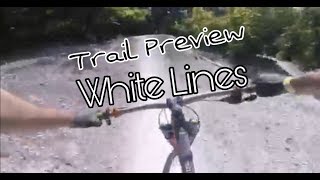
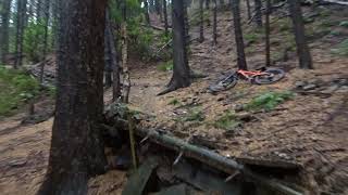
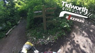
"Recently reworked in collaboration with B1KE’s partners in grime, ‘DirtKraft’, White Line is Fun on Flow and Freeride hits. It is a series of jumps that descends pretty much straight down the hill. Starting with a fairly innocuous step up riders are straight into a couple of doubles that cannot be rolled. Which then leads into a set of progressively larger step downs. Riders need to be capable of jumping and managing themselves in the air to be able to safely ride this trail. Poppy lips and long landings offer riders of growing ability loads of progression but it isn’t for the feint heart, culminating on a long carry step down into the iconic 43ft final table and final hip to finish. A firm favourite that deserves best the praise and respect riders give it." - Tidworth Freeride Bike Park

Bike Park

Recent Activity on Trail

Past Week
  • 0 rides
  •  
6 Months
  • 2 rides
  • 10 miles avg distance
All
  • 31 rides
  • Last: May 29, 2026
c1c2c3c4
January
February
March
April
May
June
July
August
September
October
November
December
Status:
on Jun 5, 2020
Dry
Avg: 4.13 (1 votes)
Your vote: 0

view (727)
close
3D
Trail Conditions
  • Unknown
  • Snow Groomed
  • Snow Packed
  • Snow Covered
  • Snow Cover Partial
  • Freeze/thaw Cycle
  • Icy
  • Prevalent Mud
  • Wet
  • Variable
  • Ideal
  • Dry
  • Very Dry
Trail Flow (Ridden Direction)
Trailforks scans users ridelogs to determine the most popular direction each trail is ridden. A good flowing trail network will have most trails flowing in a single direction according to their intension.
The colour categories are based on what percentage of riders are riding a trail in its intended direction.
  • > 96%
  • > 90%
  • > 80%
  • > 70%
  • > 50%
  • < 50%
  • bi-directional trail
  • no data
Trail Last Ridden
Trailforks scans ridelogs to determine the last time a trail was ridden.
  • < 2 days
  • < 1 week
  • < 2 weeks
  • < 1 month
  • < 6 months
  • > 6 months
Trail Ridden Direction
The intended direction a trail should be ridden.
  • Downhill Only
  • Downhill Primary
  • Both Directions
  • Uphill Primary
  • Uphill Only
  • One Direction
Contribute Details
Colors indicate trail is missing specified detail.
  • Description
  • Photos
  • Description & Photos
  • Videos
Trail Popularity ?
Trailforks scans ridelogs to determine which trails are ridden the most in the last 9 months. Trails are compared with nearby trails in the same city region with a possible 25 colour shades. Think of this as a heatmap, more rides = more kinetic energy = warmer colors.
  • most popular
  • popular
  • less popular
  • not popular
ATV/ORV/OHV Filter
Max Vehicle Width
inches
US Cell Coverage
Legend
cell carrier legend

Radar Time
Activity Recordings
Trailforks uses anonymized public activity data. ?
Activity Recordings
Trailforks uses anonymized public activity data. ?
Personal Heatmap
Activity Types
all / none
Options
2
Date range month
Winter Trails
Warning A routing network for winter maps does not exist. Selecting trails using the winter trails layer has been disabled.
Missing Trails
Most Popular
Least Popular
Trails are colored based on popularity. The more popular a trail is, the more red. Less popular trails trend towards green.
Jump Magnitude Heatmap
Heatmap of where riders jump on trails. Zoom in to see individual jumps, click circles to view jump details.
BC Backroad Status

Service Road Atlas is a free to use, community-driven service for viewing and creating reports on the numerous back-country service roads around B.C. and Alberta.

map legend
Slope Aspect
Direction the slope faces
Flat N NE E SE S SW W NW
Trails Deemphasized
Trails are shown in grey.
disable
Only show trails with no bike usage.
Enable
Suggested Layers
Based on selected activity type

    Save the current map location and zoom level as your default home location whenever this page is loaded.

    Save
        Directions to white-line trailhead (51.219344, -1.660934)

        Photos

        44 more »
        135 |
        Apr 22, 2019 @ 1:51am
        Apr 22, 2019
        106 |
        Apr 22, 2019 @ 1:51am
        Apr 22, 2019
        97 |
        Apr 22, 2019 @ 1:51am
        Apr 22, 2019
        135 |
        Mar 25, 2011 @ 3:14pm
        Mar 25, 2011

        Videos

        15 more »
        Tidworth White Lines Trail Preview 2018
        0:27 | 216 | Mar 27, 2022 , Salisbury
        Edenfield Mtb RAW
        0:01 | 218 | Oct 29, 2020 , Salisbury
        Tidworth Freeride Downhill Day - 3 Jun 18 -...
        12:56 | 373 | Aug 6, 2018 , Salisbury
        Meria eOneSixty ⚡️
        0:14 | 798 | Aug 9, 2018 , Salisbury

        Reviews / Comments

        No reviews yet, be the first to write a review or ask a question.
        Use trail reports to comment on trail conditions.


        We hope you've been enjoying Trailforks!

        Create a FREE account to view trail comments and much more.

        • By c1c51 & contributors
        • #138462 - 2,133 views

        Frequently Asked Questions About White Line

        Where is White Line located?
        White Line is located in Tidworth Freeride Park, Salisbury, United Kingdom. It is part of the Tidworth Freeride Park trail network. The trailhead is located at coordinates 51.21934, -1.66093.
        How hard is White Line?
        White Line is rated as Black difficulty. The physical rating is Moderate. The average grade is 12.409%.
        What is the elevation gain for White Line?
        The trail has 189 ft of elevation descent. The elevation ranges from 380 ft to 569 ft.
        Is White Line a point to point trail?
        Yes, White Line is a point to point trail. The direction is Downhill Only. The trail type is machine groomed.

        Hit the Trail

        Open in App

        Get this trail on your phone instantly.
        open trail in app

        Download Trail

        Save to wishlist, Garmin & download.
        save the trail

        Find Related Routes

        Find routes and users activities that include this trail.
        find routes for this trail

        You must enter a description before submitting.