more stats
5,167 ft
Distance
124 ft
Climb
-160 ft
Descent
00:11:59
Avg time
-35 ft
Altitude change
511 ft
Altitude min
649 ft
Altitude max
547 ft
Altitude start
512 ft
Altitude end
-0.7%
Grade
-18.3%
Grade max
26.2%
Grade min
1,985 ft
Distance climb
2,897 ft
Distance down
285 ft
Distance flat
00:11:59
Avg time

White Rabbit Details

  • Activities
    • Mountain Bike
    • E-Bike
    • Hike
    • Trail Running
  • Riding Area
    Alice Lake & Highlands
    Squamish, British Columbia
  • Difficulty Rating
  • Local Popularity
    55 in Mountain Biking [+]
    • 50 in E-Biking
    • 60 in Trail Running
    • 30 in Hiking
  • Global Ranking
    #76287 in Mountain Biking [+]
    • #75342 in E-Biking
    • #82203 in Trail Running
    • #111579 in Hiking
  • Trail Type
    Singletrack
  • Bike Type
    XC
  • Physical Rating
    Easy
  • Dogs Allowed
    Yes
  • eBike Allowed
    Yes up to Class 1

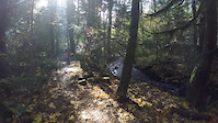
With a a couple of steep drops, a few off camber trail crossing logs and some tight turns White Rabbit is a fun trail to practice and build your basic skills and work on agility. When you come out of the woods for the first time look for the trail to continue uphill and for the entrance back into tree cover to have boulders preventing entrance of anything wider than a bike. After clearing the pile of rocks at the top of the climb be ready for a fast and winding descent to the main road in Alice Lake exiting immediately across from Wonderland.

From the perspective of location and putting together a nice sequence of trails, White Rabbit is a logical preamble to riding Wonderland. However, be aware that it is a half notch more technical than Wonderland.

Local Trail Association
Traditionally Indigenous Territory

Recent Activity on Trail

Past Week
  • 2 rides
  • 8 miles average
6 Months
  • 23 rides
  • 10 miles avg distance
All
  • 326 rides
  • Last: May 24, 2026
c1c2c3c4
January
February
March
April
May
June
July
August
September
October
November
December
update trails status or condition

White Rabbit Trail Reports

statusdatedescription
Jun 12, 2025 @ 7:42am
Jun 12, 2025
Dryden Creek Wildfire
Mar 3, 2025 @ 1:55pm
Mar 3, 2025
Feb 3, 2025 @ 7:24pm
Feb 3, 2025
reporter
Sep 4, 2024 @ 3:51pm
Sep 4, 2024
Tree down blocking trail near Alice Lake Rd exit.
Jul 19, 2024 @ 2:31pm
Jul 19, 2024
more »
Status:
on Jun 12, 2025
Avg: 3.87 (19 votes)
Your vote: 0

view (2,243)
close
3D
Trail Conditions
  • Unknown
  • Snow Groomed
  • Snow Packed
  • Snow Covered
  • Snow Cover Partial
  • Freeze/thaw Cycle
  • Icy
  • Prevalent Mud
  • Wet
  • Variable
  • Ideal
  • Dry
  • Very Dry
Trail Flow (Ridden Direction)
Trailforks scans users ridelogs to determine the most popular direction each trail is ridden. A good flowing trail network will have most trails flowing in a single direction according to their intension.
The colour categories are based on what percentage of riders are riding a trail in its intended direction.
  • > 96%
  • > 90%
  • > 80%
  • > 70%
  • > 50%
  • < 50%
  • bi-directional trail
  • no data
Trail Last Ridden
Trailforks scans ridelogs to determine the last time a trail was ridden.
  • < 2 days
  • < 1 week
  • < 2 weeks
  • < 1 month
  • < 6 months
  • > 6 months
Trail Ridden Direction
The intended direction a trail should be ridden.
  • Downhill Only
  • Downhill Primary
  • Both Directions
  • Uphill Primary
  • Uphill Only
  • One Direction
Contribute Details
Colors indicate trail is missing specified detail.
  • Description
  • Photos
  • Description & Photos
  • Videos
Trail Popularity ?
Trailforks scans ridelogs to determine which trails are ridden the most in the last 9 months. Trails are compared with nearby trails in the same city region with a possible 25 colour shades. Think of this as a heatmap, more rides = more kinetic energy = warmer colors.
  • most popular
  • popular
  • less popular
  • not popular
ATV/ORV/OHV Filter
Max Vehicle Width
inches
US Cell Coverage
Legend
cell carrier legend

Radar Time
Activity Recordings
Trailforks uses anonymized public activity data. ?
Activity Recordings
Trailforks uses anonymized public activity data. ?
Personal Heatmap
Activity Types
all / none
Options
2
Date range month
Winter Trails
Warning A routing network for winter maps does not exist. Selecting trails using the winter trails layer has been disabled.
Missing Trails
Most Popular
Least Popular
Trails are colored based on popularity. The more popular a trail is, the more red. Less popular trails trend towards green.
Jump Magnitude Heatmap
Heatmap of where riders jump on trails. Zoom in to see individual jumps, click circles to view jump details.
BC Backroad Status

Service Road Atlas is a free to use, community-driven service for viewing and creating reports on the numerous back-country service roads around B.C. and Alberta.

map legend
Slope Aspect
Direction the slope faces
Flat N NE E SE S SW W NW
Trails Deemphasized
Trails are shown in grey.
disable
Only show trails with no bike usage.
Enable
Suggested Layers
Based on selected activity type

    Save the current map location and zoom level as your default home location whenever this page is loaded.

    Save
        Directions to white-rabbit-0 trailhead (49.791060, -123.132370)

        Photos

        24 more »
        255 |
        Jun 10, 2019 @ 10:44am
        Jun 10, 2019
        454 |
        Sep 7, 2015 @ 9:26pm
        Sep 7, 2015
        33 |
        Mar 21, 2024 @ 12:13pm
        Mar 21, 2024
        37 |
        Mar 21, 2024 @ 12:05pm
        Mar 21, 2024

        Videos

        2 more »
        GoPro Fusion:  Rabbit Hill Road to Terwilly
        2:44 | 93 | Jan 26, 2020 , Squamish
        Selfies ... video style
        2:26 | 528 | Oct 14, 2016 , Squamish

        Trail Lists

        • bms
          28 trails

        Routes with this trail

        4.4 36 miles 8,106 ft 66
        this course I have created is from my biggest ride that I have done so far. it includes many trails from...
        3.0 63 miles 10,251 ft 45
        A 100km MTB route in Squamish
        6 miles 1,107 ft 4
        Exploring Cat Lake trails

        7 Reviews & Comments


        We hope you've been enjoying Trailforks!

        Create a FREE account to view trail comments and much more.

        • By canadakaTF Pro Trailforks & contributors
        • #3057 - 7,938 views

        Frequently Asked Questions About White Rabbit

        Where is White Rabbit located?
        White Rabbit is located in Alice Lake & Highlands, Squamish, British Columbia, Canada. It is part of the Alice Lake & Highlands trail network. The trailhead is located at coordinates 49.79106, -123.13237.
        How hard is White Rabbit?
        White Rabbit is rated as Blue difficulty. The physical rating is Easy. The average grade is 0.7%.
        What is the elevation gain for White Rabbit?
        White Rabbit has 124 ft of elevation gain. The trail has 160 ft of elevation descent. The elevation ranges from 511 ft to 649 ft.
        How long is White Rabbit?
        White Rabbit is 5,167 ft long. The trail type is singletrack.

        Hit the Trail

        Open in App

        Get this trail on your phone instantly.
        open trail in app

        Download Trail

        Save to wishlist, Garmin & download.
        save the trail

        Find Related Routes

        Find routes and users activities that include this trail.
        find routes for this trail

        You must enter a description before submitting.