more stats
4,177 ft
Distance
94 ft
Climb
-175 ft
Descent
00:08:09
Avg time
-80 ft
Altitude change
8,691 ft
Altitude min
8,825 ft
Altitude max
8,771 ft
Altitude start
8,691 ft
Altitude end
-1.924%
Grade
-26.969%
Grade max
20.455%
Grade min
1,235 ft
Distance climb
2,524 ft
Distance down
419 ft
Distance flat
00:08:09
Avg time

Whoop-di-doos Details

  • Activities
    • Mountain Bike
    • Hike
    • Trail Running
  • Riding Area
    Magnolia
    Nederland, Colorado
  • AKA
    FS925.1E
  • Difficulty Rating
  • Local Popularity
    95 in Mountain Biking [+]
    • 95 in Trail Running
    • 95 in Hiking
  • Global Ranking
    #43939 in Mountain Biking [+]
    • #30436 in Trail Running
    • #32774 in Hiking
  • Trail Type
    Singletrack
  • Bike Type
    AM, XC
  • Direction
    Both Directions
  • Climb Difficulty
    Blue
  • Physical Rating
    Moderate
  • Trail Visibility
    Always easy to follow
  • Family Friendly
    Yes
  • Dogs Allowed
    Yes
  • eBike Allowed
  • TTFs on Trail
    Drop, Rock Garden
  • Land Owner
    USFS

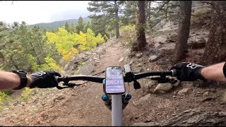
Good trail in both directions. Connections to Aspen Alley and the main West Mag parking area. Rolling easy to moderate singletrack trail recently rerouted by Boulder Mountainbike Alliance per the Magnolia Trails Plan recently approved by the USFS. The view from the top of this trail is amazing and a worthy point to stop and and take in the surrounding area including Eldora Ski Area and the Continental Divide beyond. Nothing technical but a little bit of exposure in the middle section. Keep your eyes up while climbing as downhill speeds can be fast.

Trail Supporters
Traditionally Indigenous Territory

Recent Activity on Trail

Past Week
  • 4 rides
  • 13 miles average
6 Months
  • 19 rides
  • 11 miles avg distance
All
  • 409 rides
  • Last: Jun 19, 2026
c1c2c3c4
January
February
March
April
May
June
July
August
September
October
November
December
update trails status or condition

Whoop-di-doos Trail Reports

statusdatedescription
Oct 17, 2024 @ 11:04am
Oct 17, 2024
Jun 25, 2024 @ 10:07am
Jun 25, 2024
May 27, 2024 @ 11:58am
May 27, 2024
Sep 21, 2023 @ 2:38am
Sep 21, 2023
Jun 25, 2023 @ 7:39pm
Jun 25, 2023
Dry and ready to ride! As usual, avoid any muddy spots, but the main whoopdies are ready to rock.
more »
Status:
on Oct 17, 2024
Ideal
Avg: 3.91 (7 votes)
Your vote: 0

view (2,448)
close
3D
Trail Conditions
  • Unknown
  • Snow Groomed
  • Snow Packed
  • Snow Covered
  • Snow Cover Partial
  • Freeze/thaw Cycle
  • Icy
  • Prevalent Mud
  • Wet
  • Variable
  • Ideal
  • Dry
  • Very Dry
Trail Flow (Ridden Direction)
Trailforks scans users ridelogs to determine the most popular direction each trail is ridden. A good flowing trail network will have most trails flowing in a single direction according to their intension.
The colour categories are based on what percentage of riders are riding a trail in its intended direction.
  • > 96%
  • > 90%
  • > 80%
  • > 70%
  • > 50%
  • < 50%
  • bi-directional trail
  • no data
Trail Last Ridden
Trailforks scans ridelogs to determine the last time a trail was ridden.
  • < 2 days
  • < 1 week
  • < 2 weeks
  • < 1 month
  • < 6 months
  • > 6 months
Trail Ridden Direction
The intended direction a trail should be ridden.
  • Downhill Only
  • Downhill Primary
  • Both Directions
  • Uphill Primary
  • Uphill Only
  • One Direction
Contribute Details
Colors indicate trail is missing specified detail.
  • Description
  • Photos
  • Description & Photos
  • Videos
Trail Popularity ?
Trailforks scans ridelogs to determine which trails are ridden the most in the last 9 months. Trails are compared with nearby trails in the same city region with a possible 25 colour shades. Think of this as a heatmap, more rides = more kinetic energy = warmer colors.
  • most popular
  • popular
  • less popular
  • not popular
ATV/ORV/OHV Filter
Max Vehicle Width
inches
US Cell Coverage
Legend
cell carrier legend

Radar Time
Activity Recordings
Trailforks uses anonymized public activity data. ?
Activity Recordings
Trailforks uses anonymized public activity data. ?
Personal Heatmap
Activity Types
all / none
Options
2
Date range month
Winter Trails
Warning A routing network for winter maps does not exist. Selecting trails using the winter trails layer has been disabled.
Missing Trails
Most Popular
Least Popular
Trails are colored based on popularity. The more popular a trail is, the more red. Less popular trails trend towards green.
Jump Magnitude Heatmap
Heatmap of where riders jump on trails. Zoom in to see individual jumps, click circles to view jump details.
BC Backroad Status

Service Road Atlas is a free to use, community-driven service for viewing and creating reports on the numerous back-country service roads around B.C. and Alberta.

map legend
Slope Aspect
Direction the slope faces
Flat N NE E SE S SW W NW
Trails Deemphasized
Trails are shown in grey.
disable
Only show trails with no bike usage.
Enable
Suggested Layers
Based on selected activity type

    Save the current map location and zoom level as your default home location whenever this page is loaded.

    Save
        Directions to whoopdidoos trailhead (39.950130, -105.509340)

        Photos

        No photos have been added for Whoop-di-doos yet, add a photo.

        Videos

        1 more »
        Whoop-di-doos - West Magnolia - Nederland -...
        3:37 | 35 | Sep 21, 2025 , Nederland

        Routes with this trail

        5.0 14 miles 1,487 ft 12 Loop
        This loopy route hits most of the lower West Mag trails in their preferred direction. This is a solid...
        13 miles 1,632 ft 10 Loop
        A fun loop through some of the new singletrack that has been built in the area. There is a lot more to...
        26 miles 2,819 ft 15
        NedNed MTB Course

        Reviews / Comments

        No reviews yet, be the first to write a review or ask a question.
        Use trail reports to comment on trail conditions.


        We hope you've been enjoying Trailforks!

        Create a FREE account to view trail comments and much more.

        • By toddTF Pro Trailforks & contributors
        • #13755 - 2,782 views

        Frequently Asked Questions About Whoop-di-doos

        Where is Whoop-di-doos located?
        Whoop-di-doos is located in Magnolia, Nederland, Colorado, United States. It is part of the Magnolia trail network. The trailhead is located at coordinates 39.95013, -105.50934.
        How hard is Whoop-di-doos?
        Whoop-di-doos is rated as Blue difficulty. The physical rating is Moderate. The average grade is 1.924%. The climb difficulty is rated Blue.
        What is the elevation gain for Whoop-di-doos?
        Whoop-di-doos has 94 ft of elevation gain. The trail has 175 ft of elevation descent. The elevation ranges from 8,691 ft to 8,825 ft.
        Is Whoop-di-doos a point to point trail?
        Whoop-di-doos is not a point to point trail. The direction is Both Directions. The trail type is singletrack.

        Hit the Trail

        Open in App

        Get this trail on your phone instantly.
        open trail in app

        Download Trail

        Save to wishlist, Garmin & download.
        save the trail

        Find Related Routes

        Find routes and users activities that include this trail.
        find routes for this trail

        You must enter a description before submitting.