more stats
2,090 ft
Distance
-155 ft
Descent
00:06:22
Avg time
-156 ft
Altitude change
123 ft
Altitude min
279 ft
Altitude max
279 ft
Altitude start
125 ft
Altitude end
-7.5%
Grade
-42.9%
Grade max
2%
Grade min
125 ft
Distance climb
1,857 ft
Distance down
112 ft
Distance flat
00:06:22
Avg time

Widok Details

  • Activities
    • Mountain Bike
    • Hike
    • Trail Running
  • Riding Area
    Puszcza Bukowa
    Szczecin
  • AKA
    DH Widok Wzgórze Akademickie
  • Difficulty Rating
  • Voted Difficulty
    Black (1 vote)
  • Local Popularity
    35 in Mountain Biking [+]
    • 5 in Trail Running
    • 60 in Hiking
  • Global Ranking
    #114937 in Mountain Biking [+]
    • #139202 in Trail Running
    • #96571 in Hiking
  • Trail Type
    Singletrack
  • Bike Type
    DH, AM
  • Direction
    Downhill Only
  • Trail Visibility
    Sometimes hard to follow
  • Season
    Marzec-Listopad
  • Dogs Allowed
    Yes
  • TTFs on Trail
    Bridge, Drop, Jump, Gap Jump, Rock Garden, Other
  • Year Opened
    2000

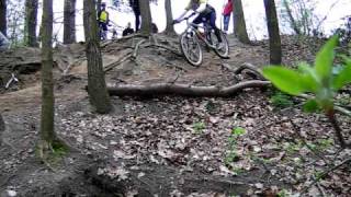
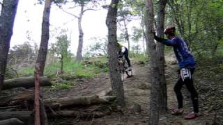
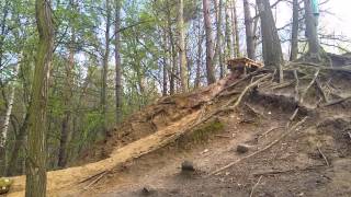
Jedna z pierwszych tras DH w Szczecinie. W latach 2000-2009 odbywały się tu lokalne zawody. Początek trasy stromy, następnie siłowy odcinek, ostatnia cześć trasy bardzo stroma i trudna technicznie.

This trail is unsanctioned.

Recent Activity on Trail

Past Week
  • 0 rides
  •  
6 Months
  • 1 rides
  • 41.8 km avg distance
All
  • 20 rides
  • Last: May 31, 2026
c1c2c3c4
January
February
March
April
May
June
July
August
September
October
November
December
update trails status or condition

Widok Trail Reports

Status:
on Jan 6, 2024
Snow Covered
Avg: 4.42 (8 votes)
Your vote: 0

view (142)
close
3D
Trail Conditions
  • Unknown
  • Snow Groomed
  • Snow Packed
  • Snow Covered
  • Snow Cover Partial
  • Freeze/thaw Cycle
  • Icy
  • Prevalent Mud
  • Wet
  • Variable
  • Ideal
  • Dry
  • Very Dry
Trail Flow (Ridden Direction)
Trailforks scans users ridelogs to determine the most popular direction each trail is ridden. A good flowing trail network will have most trails flowing in a single direction according to their intension.
The colour categories are based on what percentage of riders are riding a trail in its intended direction.
  • > 96%
  • > 90%
  • > 80%
  • > 70%
  • > 50%
  • < 50%
  • bi-directional trail
  • no data
Trail Last Ridden
Trailforks scans ridelogs to determine the last time a trail was ridden.
  • < 2 days
  • < 1 week
  • < 2 weeks
  • < 1 month
  • < 6 months
  • > 6 months
Trail Ridden Direction
The intended direction a trail should be ridden.
  • Downhill Only
  • Downhill Primary
  • Both Directions
  • Uphill Primary
  • Uphill Only
  • One Direction
Contribute Details
Colors indicate trail is missing specified detail.
  • Description
  • Photos
  • Description & Photos
  • Videos
Trail Popularity ?
Trailforks scans ridelogs to determine which trails are ridden the most in the last 9 months. Trails are compared with nearby trails in the same city region with a possible 25 colour shades. Think of this as a heatmap, more rides = more kinetic energy = warmer colors.
  • most popular
  • popular
  • less popular
  • not popular
ATV/ORV/OHV Filter
Max Vehicle Width
inches
US Cell Coverage
Legend
cell carrier legend

Radar Time
Activity Recordings
Trailforks uses anonymized public activity data. ?
Activity Recordings
Trailforks uses anonymized public activity data. ?
Personal Heatmap
Activity Types
all / none
Options
2
Date range month
Winter Trails
Warning A routing network for winter maps does not exist. Selecting trails using the winter trails layer has been disabled.
Missing Trails
Most Popular
Least Popular
Trails are colored based on popularity. The more popular a trail is, the more red. Less popular trails trend towards green.
Jump Magnitude Heatmap
Heatmap of where riders jump on trails. Zoom in to see individual jumps, click circles to view jump details.
BC Backroad Status

Service Road Atlas is a free to use, community-driven service for viewing and creating reports on the numerous back-country service roads around B.C. and Alberta.

map legend
Slope Aspect
Direction the slope faces
Flat N NE E SE S SW W NW
Trails Deemphasized
Trails are shown in grey.
disable
Only show trails with no bike usage.
Enable
Suggested Layers
Based on selected activity type

    Save the current map location and zoom level as your default home location whenever this page is loaded.

    Save
        Directions to widok-167169 trailhead (53.367640, 14.617070)

        Photos

        58 more »
        34 |
        Sep 7, 2025 @ 11:13am
        Sep 7, 2025
        110 |
        Jun 11, 2021 @ 6:08am
        Jun 11, 2021
        108 |
        Jun 11, 2021 @ 6:07am
        Jun 11, 2021
        138 |
        May 17, 2020 @ 10:05am
        May 17, 2020

        Videos

        7 more »
        featured Widok Zawody 2004
        5:05 | 211 | Apr 14, 2019 , Szczecin
        YouTube
        0:07 | 292 | Jun 29, 2020 , Szczecin
        YouTube
        0:13 | 300 | Jun 29, 2020 , Szczecin
        YouTube
        0:19 | 312 | Jun 29, 2020 , Szczecin

        Reviews / Comments

        No reviews yet, be the first to write a review or ask a question.
        Use trail reports to comment on trail conditions.


        We hope you've been enjoying Trailforks!

        Create a FREE account to view trail comments and much more.

        • #167169 - 1,834 views

        Frequently Asked Questions About Widok

        Where is Widok located?
        Widok is located in Puszcza Bukowa, Szczecin, Poland. It is part of the Puszcza Bukowa trail network. The trailhead is located at coordinates 53.36764, 14.61707.
        How hard is Widok?
        Widok is rated as Red difficulty. The average grade is 7.5%.
        What is the elevation gain for Widok?
        The trail has 47 m of elevation descent. The elevation ranges from 38 m to 85 m.
        Is Widok a point to point trail?
        Yes, Widok is a point to point trail. The direction is Downhill Only. The trail type is singletrack.

        Hit the Trail

        Open in App

        Get this trail on your phone instantly.
        open trail in app

        Download Trail

        Save to wishlist, Garmin & download.
        save the trail

        Find Related Routes

        Find routes and users activities that include this trail.
        find routes for this trail

        You must enter a description before submitting.