more stats
1,509 ft
Distance
-306 ft
Descent
00:05:46
Avg time
-306 ft
Altitude change
1,597 ft
Altitude min
1,903 ft
Altitude max
1,903 ft
Altitude start
1,598 ft
Altitude end
-20.3%
Grade
-75.2%
Grade max
-2.7%
Grade min
1,509 ft
Distance down
00:05:46
Avg time

Widowmaker Details

  • Activities
    • Mountain Bike
    • E-Bike
    • Hike
    • Trail Running
  • Riding Area
    Topanga State Park
    Santa Monica, California
  • Difficulty Rating
  • Voted Difficulty
    Black Diamond (2 votes)
  • Local Popularity
    55 in Mountain Biking [+]
    • 65 in E-Biking
    • 5 in Trail Running
    • 45 in Hiking
  • Global Ranking
    #102515 in Mountain Biking [+]
    • #59632 in E-Biking
    • #129637 in Trail Running
    • #98554 in Hiking
  • Trail Type
    Singletrack
  • Bike Type
    AM
  • Direction
    Downhill Primary
    Popular Direction Shown
  • Dogs Allowed
    Yes
  • eBike Allowed

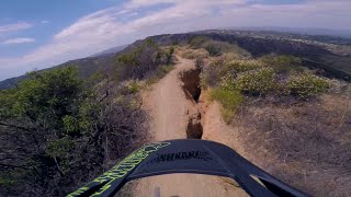
Very steep ridge downhill. Not extremely technical, but very loose surface, average grade of over 25%, skinny in places, and high consequences. Not for the faint of heart.

Traditionally Indigenous Territory

Recent Activity on Trail

Past Week
  • 0 rides
  •  
6 Months
  • 3 rides
  • 17 miles avg distance
All
  • 53 rides
  • Last: May 30, 2026
c1c2c3c4
January
February
March
April
May
June
July
August
September
October
November
December
update trails status or condition

Widowmaker Trail Reports

statusdatedescription
Jun 21, 2025 @ 12:45pm
Jun 21, 2025
Easier than before, still fun. Very loose near the bottom.
Apr 5, 2025 @ 3:58am
Apr 5, 2025
Wiped out by fire crews
Jun 22, 2024 @ 8:26am
Jun 22, 2024
Feb 18, 2024 @ 10:58am
Feb 18, 2024
Deep ruts from the rains
Nov 3, 2021 @ 9:24am
Nov 3, 2021
Running great! Yeah, there are some deep ruts but easily avoidable.
more »
Status:
on Jun 21, 2025
Variable
Avg: 4.08 (5 votes)
Your vote: 0

view (503)
close
3D
Trail Conditions
  • Unknown
  • Snow Groomed
  • Snow Packed
  • Snow Covered
  • Snow Cover Partial
  • Freeze/thaw Cycle
  • Icy
  • Prevalent Mud
  • Wet
  • Variable
  • Ideal
  • Dry
  • Very Dry
Trail Flow (Ridden Direction)
Trailforks scans users ridelogs to determine the most popular direction each trail is ridden. A good flowing trail network will have most trails flowing in a single direction according to their intension.
The colour categories are based on what percentage of riders are riding a trail in its intended direction.
  • > 96%
  • > 90%
  • > 80%
  • > 70%
  • > 50%
  • < 50%
  • bi-directional trail
  • no data
Trail Last Ridden
Trailforks scans ridelogs to determine the last time a trail was ridden.
  • < 2 days
  • < 1 week
  • < 2 weeks
  • < 1 month
  • < 6 months
  • > 6 months
Trail Ridden Direction
The intended direction a trail should be ridden.
  • Downhill Only
  • Downhill Primary
  • Both Directions
  • Uphill Primary
  • Uphill Only
  • One Direction
Contribute Details
Colors indicate trail is missing specified detail.
  • Description
  • Photos
  • Description & Photos
  • Videos
Trail Popularity ?
Trailforks scans ridelogs to determine which trails are ridden the most in the last 9 months. Trails are compared with nearby trails in the same city region with a possible 25 colour shades. Think of this as a heatmap, more rides = more kinetic energy = warmer colors.
  • most popular
  • popular
  • less popular
  • not popular
ATV/ORV/OHV Filter
Max Vehicle Width
inches
US Cell Coverage
Legend
cell carrier legend

Radar Time
Activity Recordings
Trailforks uses anonymized public activity data. ?
Activity Recordings
Trailforks uses anonymized public activity data. ?
Personal Heatmap
Activity Types
all / none
Options
2
Date range month
Winter Trails
Warning A routing network for winter maps does not exist. Selecting trails using the winter trails layer has been disabled.
Missing Trails
Most Popular
Least Popular
Trails are colored based on popularity. The more popular a trail is, the more red. Less popular trails trend towards green.
Jump Magnitude Heatmap
Heatmap of where riders jump on trails. Zoom in to see individual jumps, click circles to view jump details.
BC Backroad Status

Service Road Atlas is a free to use, community-driven service for viewing and creating reports on the numerous back-country service roads around B.C. and Alberta.

map legend
Slope Aspect
Direction the slope faces
Flat N NE E SE S SW W NW
Trails Deemphasized
Trails are shown in grey.
disable
Only show trails with no bike usage.
Enable
Suggested Layers
Based on selected activity type

    Save the current map location and zoom level as your default home location whenever this page is loaded.

    Save
        Directions to widowmaker-76407 trailhead (34.128530, -118.537870)

        Photos

        No photos have been added for Widowmaker yet, add a photo.

        Videos

        3 more »
        Widowmaker - Santa Monica Mountains
        0:59 | 379 | Oct 15, 2022 , Santa Monica
        WIDOW MAKER : MTB NOT SO CLEAN
        2:16 | 662 | Jun 25, 2020 , Santa Monica
        Enduro Lap: Widow Maker, Santa Monica CA, 2015
        2:39 | 847 | Dec 25, 2018 , Santa Monica

        8 Reviews & Comments


        We hope you've been enjoying Trailforks!

        Create a FREE account to view trail comments and much more.

        • By ersz & contributors
        • #76407 - 4,224 views

        Frequently Asked Questions About Widowmaker

        Where is Widowmaker located?
        Widowmaker is located in Topanga State Park, Santa Monica, California, United States. It is part of the Topanga State Park trail network. The trailhead is located at coordinates 34.12853, -118.53787.
        How hard is Widowmaker?
        Widowmaker is rated as Double Black Diamond difficulty. The average grade is 20.3%.
        What is the elevation gain for Widowmaker?
        The trail has 306 ft of elevation descent. The elevation ranges from 1,597 ft to 1,903 ft.
        Is Widowmaker a point to point trail?
        Widowmaker is not a point to point trail. The direction is Downhill Primary. The trail type is singletrack.

        Hit the Trail

        Open in App

        Get this trail on your phone instantly.
        open trail in app

        Download Trail

        Save to wishlist, Garmin & download.
        save the trail

        Find Related Routes

        Find routes and users activities that include this trail.
        find routes for this trail

        You must enter a description before submitting.