more stats
1.3 miles
Distance
732 ft
Climb
00:22:18
Avg time
732 ft
Altitude change
3,792 ft
Altitude min
4,524 ft
Altitude max
3,792 ft
Altitude start
4,524 ft
Altitude end
10.6%
Grade
3.4%
Grade max
61.1%
Grade min
1 mile
Distance climb
00:22:18
Avg time

Woods Gulch Details

  • Activities
    • Mountain Bike
    • Horse
    • Hike
    • Trail Running
    • Snowshoe
  • Riding Area
    The Rattlesnake
    Missoula, Montana
  • Ref Number
    #513
  • AKA
    Sheep Mountain
  • Difficulty Rating
  • Local Popularity
    85 in Mountain Biking [+]
    • 90 in Trail Running
    • 95 in Hiking
    • 5 in Horseback
    • 5 in Snowshoeing
  • Global Ranking
    #17441 in Mountain Biking [+]
    • #36248 in Trail Running
    • #25538 in Hiking
  • Hiking SAC Scale
    T2 Mountain Hiking
  • Trail Type
    Singletrack
  • Snow Grooming
    Backcountry
  • Bike Type
    AM
  • Direction
    Both Directions
  • Climb Difficulty
    Blue
  • Physical Rating
    Hard
  • Trail Visibility
    Always easy to follow
  • Dogs Allowed
    Yes
  • eBike Allowed
  • Land Owner
    USFS

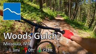
The trail starts at the Woods Gulch trailhead and provides access to Three Larch, Sidewinder, and Sheep Mountain. The Gulch is shady and stays relatively cool on hot days. It also tends to hold snow and ice longer in the winter.

The trail climbs steadily at the beginning with a couple of steeper pithches until it reaches a bridge across the creek. The grade is a bit easier after the bridge as the trail takes a switchback through an open rocky area. It then reenters the forest and climbs steeply again moderating a bit before reaching an unbridged creek crossing and the junction with the Larch Ladder foot path. The area just past the creek has a small rock garden and tends to be wet and muddy. Another climbing section brings you up out of the Gulch to the end at a multi-way trail trail junction.

Local Trail Association
Traditionally Indigenous Territory

Recent Activity on Trail

Past Week
  • 2 rides
  • 24 miles average
6 Months
  • 15 rides
  • 19 miles avg distance
All
  • 210 rides
  • Last: Jun 23, 2026
c1c2c3c4
January
February
March
April
May
June
July
August
September
October
November
December
update trails status or condition

Woods Gulch Trail Reports

statusdatedescription
May 2, 2026 @ 9:47am (America/Denver)
May 2, 2026
Apr 24, 2026 @ 12:04pm (America/Denver)
Apr 24, 2026
Mar 27, 2026 @ 11:58am (America/Denver)
Mar 27, 2026
Just one tree down near the top. Could be cleared with a good hand saw. Trail is mostly in good shape but it's wet at the bottom and there is...
Nov 11, 2025 @ 3:39pm (America/Denver)
Nov 11, 2025
Oct 21, 2025 @ 12:14pm (America/Denver)
Oct 21, 2025
more »
Status:
on May 2, 2026
Ideal
Avg: 3.88 (3 votes)
Your vote: 0

view (2,232)
close
3D
Trail Conditions
  • Unknown
  • Snow Groomed
  • Snow Packed
  • Snow Covered
  • Snow Cover Partial
  • Freeze/thaw Cycle
  • Icy
  • Prevalent Mud
  • Wet
  • Variable
  • Ideal
  • Dry
  • Very Dry
Trail Flow (Ridden Direction)
Trailforks scans users ridelogs to determine the most popular direction each trail is ridden. A good flowing trail network will have most trails flowing in a single direction according to their intension.
The colour categories are based on what percentage of riders are riding a trail in its intended direction.
  • > 96%
  • > 90%
  • > 80%
  • > 70%
  • > 50%
  • < 50%
  • bi-directional trail
  • no data
Trail Last Ridden
Trailforks scans ridelogs to determine the last time a trail was ridden.
  • < 2 days
  • < 1 week
  • < 2 weeks
  • < 1 month
  • < 6 months
  • > 6 months
Trail Ridden Direction
The intended direction a trail should be ridden.
  • Downhill Only
  • Downhill Primary
  • Both Directions
  • Uphill Primary
  • Uphill Only
  • One Direction
Contribute Details
Colors indicate trail is missing specified detail.
  • Description
  • Photos
  • Description & Photos
  • Videos
Trail Popularity ?
Trailforks scans ridelogs to determine which trails are ridden the most in the last 9 months. Trails are compared with nearby trails in the same city region with a possible 25 colour shades. Think of this as a heatmap, more rides = more kinetic energy = warmer colors.
  • most popular
  • popular
  • less popular
  • not popular
ATV/ORV/OHV Filter
Max Vehicle Width
inches
US Cell Coverage
Legend
cell carrier legend

Radar Time
Activity Recordings
Trailforks uses anonymized public activity data. ?
Activity Recordings
Trailforks uses anonymized public activity data. ?
Personal Heatmap
Activity Types
all / none
Options
2
Date range month
Winter Trails
Warning A routing network for winter maps does not exist. Selecting trails using the winter trails layer has been disabled.
Missing Trails
Most Popular
Least Popular
Trails are colored based on popularity. The more popular a trail is, the more red. Less popular trails trend towards green.
Jump Magnitude Heatmap
Heatmap of where riders jump on trails. Zoom in to see individual jumps, click circles to view jump details.
BC Backroad Status

Service Road Atlas is a free to use, community-driven service for viewing and creating reports on the numerous back-country service roads around B.C. and Alberta.

map legend
Slope Aspect
Direction the slope faces
Flat N NE E SE S SW W NW
Trails Deemphasized
Trails are shown in grey.
disable
Only show trails with no bike usage.
Enable
Suggested Layers
Based on selected activity type

    Save the current map location and zoom level as your default home location whenever this page is loaded.

    Save
        Directions to woods-gulch trailhead (46.920280, -113.948180)

        Photos

        0 more »
        29 |
        May 10, 2024 @ 2:00pm
        May 10, 2024

        Videos

        1 more »
        youtuber Woods Gulch - The Rattlesnake - Missoula, MT
        4:35 | 128 | Jul 3, 2023 , Missoula

        1 Review & Comments


        We hope you've been enjoying Trailforks!

        Create a FREE account to view trail comments and much more.

        • By aaronrbaldwinTF Pro TRAILFORKS & contributors
        • #434545 - 2,038 views

        Frequently Asked Questions About Woods Gulch

        Where is Woods Gulch located?
        Woods Gulch is located in The Rattlesnake, Missoula, Montana, United States. It is part of the The Rattlesnake trail network. The trailhead is located at coordinates 46.92028, -113.94818.
        How hard is Woods Gulch?
        Woods Gulch is rated as Blue difficulty. The physical rating is Hard. The average grade is 10.6%. The climb difficulty is rated Blue.
        What is the elevation gain for Woods Gulch?
        Woods Gulch has 732 ft of elevation gain. The elevation ranges from 3,792 ft to 4,524 ft.
        Is Woods Gulch a point to point trail?
        Woods Gulch is not a point to point trail. The direction is Both Directions. The trail type is singletrack.

        Hit the Trail

        Open in App

        Get this trail on your phone instantly.
        open trail in app

        Download Trail

        Save to wishlist, Garmin & download.
        save the trail

        Find Related Routes

        Find routes and users activities that include this trail.
        find routes for this trail

        You must enter a description before submitting.