more stats
1.2 miles
Distance
89 ft
Climb
-1,107 ft
Descent
00:18:06
Avg time
-1,019 ft
Altitude change
159 ft
Altitude min
1,178 ft
Altitude max
1,178 ft
Altitude start
161 ft
Altitude end
-16.1%
Grade
-101.7%
Grade max
27.1%
Grade min
571 ft
Distance climb
5,279 ft
Distance down
486 ft
Distance flat
00:18:06
Avg time

Worlds DH Details

  • Activities
    • Mountain Bike
    • E-Bike
  • Riding Area
    Smithfield
    Cairns
  • Difficulty Rating
  • Local Popularity
    70 in Mountain Biking [+]
    • 60 in E-Biking
  • Global Ranking
    #49857 in Mountain Biking [+]
    • #55903 in E-Biking
  • Trail Type
    Singletrack
  • Bike Type
    DH, AM
  • Trail Visibility
    Sometimes hard to follow
  • eBike Allowed
  • TTFs on Trail
    Berm, Bridge, Drop, Jump, Gap Jump, Rock Garden

World Cup / World Champs / now Crankworx Cairns track.
What else is there to say, just look at the photos and videos.
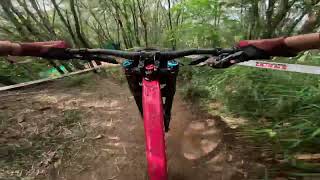
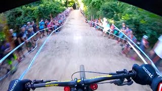
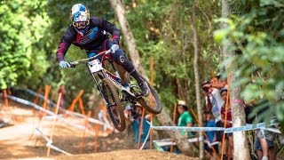
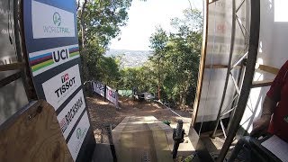
Double Black Downhill Track
Top Corners are tight and technical especially in the dry - which they are most of the year.
The rock garden is slow technical with many optional line choices, alien tree is a claybased soil feature and can be nightmare in the wet, the jumps are long gaps at high speed and the whoops are unavoidable.
Then the track ducks back into the rainforest in "vines" this technical section is difficult at speed and the Generator feature now has drops into a high speed berm to be respected. This trail - it's remoteness - technical features and speed should always be respected and advanced skill level expected.

Trail Supporters
Local Trail Association
Traditionally Indigenous Territory

Recent Activity on Trail

Past Week
  • 0 rides
  •  
6 Months
  • 0 rides
  •  
All
  • 62 rides
  • Last: Jun 16, 2026
c1c2c3c4
January
February
March
April
May
June
July
August
September
October
November
December
update trails status or condition

Worlds DH Trail Reports

statusdatedescription
May 17, 2026 @ 7:44am (Australia/Brisbane)
May 16, 2026
reporter Tree down HAZARD Dangerous high speed section. Top 1/2 of worlds DO not ride until QPWS Rangers remove this tree
Mar 6, 2026 @ 5:57pm (Australia/Brisbane)
Mar 5, 2026
Large tree down across track between Alien Tree and Ridgeline
Dec 31, 2025 @ 8:51am (Australia/Brisbane)
Dec 30, 2025
reporter
Nov 27, 2025 @ 5:43pm (Australia/Brisbane)
Nov 26, 2025
reporter Trail drying out, top corners rutted and dusty. Ridefeline vegetation and grasses at jumps need trimming/ spraying
Sep 22, 2025 @ 3:23pm (Australia/Brisbane)
Sep 21, 2025
reporter Large tree down across trail, blocking trail Reported to QPWS rangers for removal/assessment **note estimated GPS marker Please carefully ride...
more »
Status:
on May 17, 2026
Avg: 4.35 (8 votes)
Your vote: 0

view (674)
close
3D
Trail Conditions
  • Unknown
  • Snow Groomed
  • Snow Packed
  • Snow Covered
  • Snow Cover Partial
  • Freeze/thaw Cycle
  • Icy
  • Prevalent Mud
  • Wet
  • Variable
  • Ideal
  • Dry
  • Very Dry
Trail Flow (Ridden Direction)
Trailforks scans users ridelogs to determine the most popular direction each trail is ridden. A good flowing trail network will have most trails flowing in a single direction according to their intension.
The colour categories are based on what percentage of riders are riding a trail in its intended direction.
  • > 96%
  • > 90%
  • > 80%
  • > 70%
  • > 50%
  • < 50%
  • bi-directional trail
  • no data
Trail Last Ridden
Trailforks scans ridelogs to determine the last time a trail was ridden.
  • < 2 days
  • < 1 week
  • < 2 weeks
  • < 1 month
  • < 6 months
  • > 6 months
Trail Ridden Direction
The intended direction a trail should be ridden.
  • Downhill Only
  • Downhill Primary
  • Both Directions
  • Uphill Primary
  • Uphill Only
  • One Direction
Contribute Details
Colors indicate trail is missing specified detail.
  • Description
  • Photos
  • Description & Photos
  • Videos
Trail Popularity ?
Trailforks scans ridelogs to determine which trails are ridden the most in the last 9 months. Trails are compared with nearby trails in the same city region with a possible 25 colour shades. Think of this as a heatmap, more rides = more kinetic energy = warmer colors.
  • most popular
  • popular
  • less popular
  • not popular
ATV/ORV/OHV Filter
Max Vehicle Width
inches
US Cell Coverage
Legend
cell carrier legend

Radar Time
Activity Recordings
Trailforks uses anonymized public activity data. ?
Activity Recordings
Trailforks uses anonymized public activity data. ?
Personal Heatmap
Activity Types
all / none
Options
2
Date range month
Winter Trails
Warning A routing network for winter maps does not exist. Selecting trails using the winter trails layer has been disabled.
Missing Trails
Most Popular
Least Popular
Trails are colored based on popularity. The more popular a trail is, the more red. Less popular trails trend towards green.
Jump Magnitude Heatmap
Heatmap of where riders jump on trails. Zoom in to see individual jumps, click circles to view jump details.
BC Backroad Status

Service Road Atlas is a free to use, community-driven service for viewing and creating reports on the numerous back-country service roads around B.C. and Alberta.

map legend
Slope Aspect
Direction the slope faces
Flat N NE E SE S SW W NW
Trails Deemphasized
Trails are shown in grey.
disable
Only show trails with no bike usage.
Enable
Suggested Layers
Based on selected activity type

    Save the current map location and zoom level as your default home location whenever this page is loaded.

    Save
        Directions to worlds-dh trailhead (-16.809160, 145.675660)

        Photos

        93 more »
        5,057 |
        Nov 2, 2017 @ 1:31am
        Nov 2, 2017
        91 |
        May 23, 2025 @ 4:16am
        May 23, 2025
        118 |
        May 23, 2025 @ 4:16am
        May 23, 2025
        80 |
        May 22, 2025 @ 5:52am
        May 22, 2025

        Videos

        4 more »
        CRANKWORX CAIRNS RACE RUN
        5:41 | 341 | May 25, 2024 , Cairns
        Mick Hannah Finals race run Cairns world cup 2016
        3:49 | 454 | Sep 21, 2022 , Cairns
        youtuber Charging the Downhill MTB Track in Cairns:...
        4:58 | 341 | Sep 21, 2022 , Cairns
        Course Preview: Downhill World Championships...
        4:44 | 328 | Sep 21, 2022 , Cairns

        Trail Lists

        Routes with this trail

        12 miles 5,118 ft 17 Out & Back
        1 2 Stallones 3 Cloonies 4 KeGnarra 5 6 7

        Reviews / Comments

        No reviews yet, be the first to write a review or ask a question.
        Use trail reports to comment on trail conditions.


        We hope you've been enjoying Trailforks!

        Create a FREE account to view trail comments and much more.

        Frequently Asked Questions About Worlds DH

        Where is Worlds DH located?
        Worlds DH is located in Smithfield, Cairns, Australia. It is part of the Smithfield trail network. The trailhead is located at coordinates -16.80916, 145.67566.
        How hard is Worlds DH?
        Worlds DH is rated as Double Black Diamond difficulty. The average grade is 16.1%.
        What is the elevation gain for Worlds DH?
        Worlds DH has 89 ft of elevation gain. The trail has 1,107 ft of elevation descent. The elevation ranges from 159 ft to 1,178 ft.
        How long is Worlds DH?
        Worlds DH is 1.2 miles long. The trail type is singletrack.

        Hit the Trail

        Open in App

        Get this trail on your phone instantly.
        open trail in app

        Download Trail

        Save to wishlist, Garmin & download.
        save the trail

        Find Related Routes

        Find routes and users activities that include this trail.
        find routes for this trail

        You must enter a description before submitting.