more stats
8.7 miles
Distance
1,705 ft
Climb
-2,756 ft
Descent
3,727 ft
High Point
-1,050 ft
Altitude change
1,652 ft
Altitude min
2,702 ft
Altitude start
1,650 ft
Altitude end
-2.3%
Grade
-54.8%
Grade max
71.9%
Grade min
3 miles
Distance climb
5 miles
Distance down
525 ft
Distance flat

Wright Meadow Trail Details

  • Activities
    • Dirtbike/Moto
    • Mountain Bike
    • E-Bike
    • Hike
    • Trail Running
  • Riding Area
    Dark Divide
    Randle, Washington
  • Ref Number
    #80
  • Difficulty Rating
  • Voted Difficulty
    Black Diamond (1 vote)
  • Local Popularity
    5 in Mountain Biking [+]
    • 5 in E-Biking
    • 5 in Trail Running
    • 5 in Hiking
    • 5 in Dirtbiking
  • Global Ranking
    #136309 in Mountain Biking [+]
    • #176028 in E-Biking
    • #280769 in Trail Running
    • #291639 in Hiking
    • #5976 in Dirtbiking
  • Hiking SAC Scale
    T1 Hiking
  • Trail Type
    Singletrack
  • Bike Type
    AM, XC
  • Direction
    Both Directions
  • Climb Difficulty
    Double Black Diamond
  • Physical Rating
    Moderate
  • Dogs Allowed
    Yes
  • eBike Allowed
    Yes up to Class 1
  • Land Owner

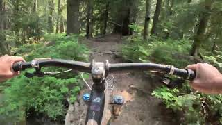
This is a multi-use trail. Popular with OHV users and Mountain Bikers.
The trail climbs out of the Lewis River Valley through a mature forest and intersects with Cussed Hollow Trail #19 about a mile from the trailhead. Continue on and cross the headwater of Copper Creek is via a bridge with a campsite nearby. A short distance upslope, the trail passes into a young tree plantation. You will pass through another plantation before crossing Forest Road 93.

Cross Forest Road 93 and travel one mile to the intersection of Forest Road 9327- ­040 and Forest Road 9327. This is also the beginning of Craggy Peak Trail #3. Further along the trail travels along Wright Meadow where elk can often be seen grazing.

The trail crosses Forest Road 9327 again before starting its descent to Clear Creek. A ford allows you to cross Clear Creek before ascending to a bench. The trail then drops to Elk Creek before climbing to Forest Road 2259-101.

source: USFS
Access Info

As of June 15, 2021 there is 3 months of parking restrictions on FS 90, which includes NF-9055. If you plan on parking anywhere near FS 90, you need to purchase a day parking pass prior to arrival at this website: https://www.recreation.gov/timed-entry/10087203

Disclaimer

This trail is maintained by the US Forest Service. Check with the USFS/Gifford Pinchot National Forest for the latest trail status.

Trail Supporters

  • USFS
    Land Manager
Local Trail Association
Traditionally Indigenous Territory

Recent Activity on Trail

Past Week
  • 0 rides
  •  
6 Months
  • 0 rides
  •  
All
  • 1 rides
  •  
update trails status or condition

Wright Meadow Trail Trail Reports

statusdatedescription
Jun 15, 2025 @ 7:53pm
Jun 15, 2025
Clear of blowdown from rock quarry (mile 5.5 on trailforks) to NF 90. Bottom 3 miles of trail could use some brushing.
Jul 18, 2024 @ 11:11am
Jul 18, 2024
9055 climb road has been cleared by Orogenesis
Jun 30, 2024 @ 11:26am
Jun 30, 2024
Clear from NF-90 to Snyder. Little brushy towards the far end. Both Snyder and Craggy Peak are snow covered above 4600 ft so you can't make a loop...
Jun 17, 2024 @ 10:32am
Jun 17, 2024
clear down from craggy peak trail
Aug 30, 2023 @ 10:47pm
Aug 30, 2023
Closed due to nearby fires
more »
Status:
on Jun 15, 2025
Ideal
Avg: 4.45 (5 votes)
Your vote: 0

view (0)
close
3D
Trail Conditions
  • Unknown
  • Snow Groomed
  • Snow Packed
  • Snow Covered
  • Snow Cover Partial
  • Freeze/thaw Cycle
  • Icy
  • Prevalent Mud
  • Wet
  • Variable
  • Ideal
  • Dry
  • Very Dry
Trail Flow (Ridden Direction)
Trailforks scans users ridelogs to determine the most popular direction each trail is ridden. A good flowing trail network will have most trails flowing in a single direction according to their intension.
The colour categories are based on what percentage of riders are riding a trail in its intended direction.
  • > 96%
  • > 90%
  • > 80%
  • > 70%
  • > 50%
  • < 50%
  • bi-directional trail
  • no data
Trail Last Ridden
Trailforks scans ridelogs to determine the last time a trail was ridden.
  • < 2 days
  • < 1 week
  • < 2 weeks
  • < 1 month
  • < 6 months
  • > 6 months
Trail Ridden Direction
The intended direction a trail should be ridden.
  • Downhill Only
  • Downhill Primary
  • Both Directions
  • Uphill Primary
  • Uphill Only
  • One Direction
Contribute Details
Colors indicate trail is missing specified detail.
  • Description
  • Photos
  • Description & Photos
  • Videos
Trail Popularity ?
Trailforks scans ridelogs to determine which trails are ridden the most in the last 9 months. Trails are compared with nearby trails in the same city region with a possible 25 colour shades. Think of this as a heatmap, more rides = more kinetic energy = warmer colors.
  • most popular
  • popular
  • less popular
  • not popular
ATV/ORV/OHV Filter
Max Vehicle Width
inches
US Cell Coverage
Legend
cell carrier legend

Radar Time
Activity Recordings
Trailforks uses anonymized public activity data. ?
Activity Recordings
Trailforks uses anonymized public activity data. ?
Personal Heatmap
Activity Types
all / none
Options
2
Date range month
Winter Trails
Warning A routing network for winter maps does not exist. Selecting trails using the winter trails layer has been disabled.
Missing Trails
Most Popular
Least Popular
Trails are colored based on popularity. The more popular a trail is, the more red. Less popular trails trend towards green.
Jump Magnitude Heatmap
Heatmap of where riders jump on trails. Zoom in to see individual jumps, click circles to view jump details.
BC Backroad Status

Service Road Atlas is a free to use, community-driven service for viewing and creating reports on the numerous back-country service roads around B.C. and Alberta.

map legend
Slope Aspect
Direction the slope faces
Flat N NE E SE S SW W NW
Trails Deemphasized
Trails are shown in grey.
disable
Only show trails with no bike usage.
Enable
Suggested Layers
Based on selected activity type

    Save the current map location and zoom level as your default home location whenever this page is loaded.

    Save
        Directions to wright-meadow-trail trailhead (46.241910, -121.948390)

        Photos

        10 more »
        105 |
        Sep 18, 2022 @ 8:36pm
        Sep 18, 2022
        273 |
        Aug 25, 2018 @ 10:57pm
        Aug 25, 2018
        301 |
        Aug 25, 2018 @ 10:57pm
        Aug 25, 2018
        337 |
        Aug 25, 2018 @ 10:57pm
        Aug 25, 2018

        Videos

        1 more »
        Wright Meadow Trail - Best Backcountry MTB...
        8:32 | 100 | Jul 30, 2024 , Randle

        Routes with this trail

        31 miles 6,370 ft 6 Loop
        Links Cussed hollow with 2x wright meadow descent and an out and back on craggy peak. Some hike a bike...

        3 Reviews & Comments


        We hope you've been enjoying Trailforks!

        Create a FREE account to view trail comments and much more.

        Frequently Asked Questions About Wright Meadow Trail

        Where is Wright Meadow Trail located?
        Wright Meadow Trail is located in Dark Divide, Randle, Washington, United States. It is part of the Dark Divide trail network. The trailhead is located at coordinates 46.24191, -121.94839.
        How hard is Wright Meadow Trail?
        Wright Meadow Trail is rated as Black Diamond difficulty. The physical rating is Moderate. The average grade is 2.3%. The climb difficulty is rated Double Black Diamond.
        What is the elevation gain for Wright Meadow Trail?
        Wright Meadow Trail has 1,705 ft of elevation gain. The trail has 2,756 ft of elevation descent. The elevation ranges from 1,652 ft to 3,727 ft.
        Is Wright Meadow Trail a point to point trail?
        Wright Meadow Trail is not a point to point trail. The direction is Both Directions. The trail type is singletrack.

        Hit the Trail

        Open in App

        Get this trail on your phone instantly.
        open trail in app

        Download Trail

        Save to wishlist, Garmin & download.
        save the trail

        Find Related Routes

        Find routes and users activities that include this trail.
        find routes for this trail

        You must enter a description before submitting.