more stats
3,707 ft
Distance
25 ft
Climb
-301 ft
Descent
00:12:55
Avg time
-276 ft
Altitude change
115 ft
Altitude min
407 ft
Altitude max
390 ft
Altitude start
115 ft
Altitude end
-7.4%
Grade
-32.5%
Grade max
8.6%
Grade min
643 ft
Distance climb
2,963 ft
Distance down
105 ft
Distance flat
00:12:55
Avg time

Ya Mum Details

  • Activities
    • Mountain Bike
    • Hike
    • Trail Running
  • Riding Area
    Mt Narra
    Sydney
  • Difficulty Rating
  • Voted Difficulty
    Black Diamond (10 votes)
  • Local Popularity
    70 in Mountain Biking [+]
    • 30 in Trail Running
    • 5 in Hiking
  • Global Ranking
    #40846 in Mountain Biking [+]
    • #120257 in Trail Running
    • #122089 in Hiking
  • Trail Type
    Singletrack
  • Bike Type
    DH, AM
  • Direction
    Downhill Only
    Popular Direction Shown
  • Physical Rating
    Hard
  • eBike Allowed
  • TTFs on Trail
    Drop, Gap Jump
  • Land Owner
    Northern Beaches Council & Garigal National Park

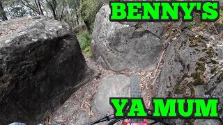
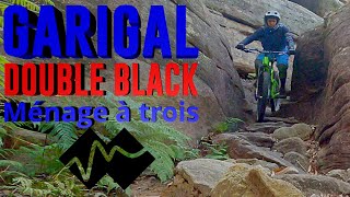
Have you ridden Ya Mum?
Starting out from one of the best rock peaks in the Beaches, the trail follows a rocky ridge line, with a bunch of tricky roll downs, jumps, gnarly chutes and a drop to finish right by the lake.

This trail is unsanctioned.

Trail Supporters
Traditionally Indigenous Territory

Recent Activity on Trail

Past Week
  • 0 rides
  •  
6 Months
  • 24 rides
  • 11.9 km avg distance
All
  • 189 rides
  • Last: Jun 14, 2026
c1c2c3c4
January
February
March
April
May
June
July
August
September
October
November
December
Status:
on Aug 16, 2025
Variable
Avg: 4.49 (12 votes)
Your vote: 0

view (1,688)
close
3D
Trail Conditions
  • Unknown
  • Snow Groomed
  • Snow Packed
  • Snow Covered
  • Snow Cover Partial
  • Freeze/thaw Cycle
  • Icy
  • Prevalent Mud
  • Wet
  • Variable
  • Ideal
  • Dry
  • Very Dry
Trail Flow (Ridden Direction)
Trailforks scans users ridelogs to determine the most popular direction each trail is ridden. A good flowing trail network will have most trails flowing in a single direction according to their intension.
The colour categories are based on what percentage of riders are riding a trail in its intended direction.
  • > 96%
  • > 90%
  • > 80%
  • > 70%
  • > 50%
  • < 50%
  • bi-directional trail
  • no data
Trail Last Ridden
Trailforks scans ridelogs to determine the last time a trail was ridden.
  • < 2 days
  • < 1 week
  • < 2 weeks
  • < 1 month
  • < 6 months
  • > 6 months
Trail Ridden Direction
The intended direction a trail should be ridden.
  • Downhill Only
  • Downhill Primary
  • Both Directions
  • Uphill Primary
  • Uphill Only
  • One Direction
Contribute Details
Colors indicate trail is missing specified detail.
  • Description
  • Photos
  • Description & Photos
  • Videos
Trail Popularity ?
Trailforks scans ridelogs to determine which trails are ridden the most in the last 9 months. Trails are compared with nearby trails in the same city region with a possible 25 colour shades. Think of this as a heatmap, more rides = more kinetic energy = warmer colors.
  • most popular
  • popular
  • less popular
  • not popular
ATV/ORV/OHV Filter
Max Vehicle Width
inches
US Cell Coverage
Legend
cell carrier legend

Radar Time
Activity Recordings
Trailforks uses anonymized public activity data. ?
Activity Recordings
Trailforks uses anonymized public activity data. ?
Personal Heatmap
Activity Types
all / none
Options
2
Date range month
Winter Trails
Warning A routing network for winter maps does not exist. Selecting trails using the winter trails layer has been disabled.
Missing Trails
Most Popular
Least Popular
Trails are colored based on popularity. The more popular a trail is, the more red. Less popular trails trend towards green.
Jump Magnitude Heatmap
Heatmap of where riders jump on trails. Zoom in to see individual jumps, click circles to view jump details.
BC Backroad Status

Service Road Atlas is a free to use, community-driven service for viewing and creating reports on the numerous back-country service roads around B.C. and Alberta.

map legend
Slope Aspect
Direction the slope faces
Flat N NE E SE S SW W NW
Trails Deemphasized
Trails are shown in grey.
disable
Only show trails with no bike usage.
Enable
Suggested Layers
Based on selected activity type

    Save the current map location and zoom level as your default home location whenever this page is loaded.

    Save
        Directions to ya-mum trailhead (-33.709500, 151.262530)

        Photos

        25 more »
        72 |
        Aug 22, 2025 @ 1:42am
        Aug 22, 2025
        72 |
        Jul 24, 2025 @ 6:08pm
        Jul 24, 2025
        59 |
        Feb 23, 2025 @ 3:07am
        Feb 23, 2025
        77 |
        Oct 29, 2024 @ 4:20am
        Oct 29, 2024

        Videos

        5 more »
        Mt Narra Double ♦ ♦ - Ya Mum and Benny's
        5:27 | 118 | Oct 28, 2025 , Sydney
        MT NARRA BENNY's & YA MUM
        5:36 | 548 | Jan 11, 2023 , Sydney
        Mt Narra eJump
        0:18 | 1621 | Jul 23, 2019 , Sydney
        The tree didn't move for me!
        0:07 | 524 | Aug 30, 2021 , Sydney

        4 Reviews & Comments


        We hope you've been enjoying Trailforks!

        Create a FREE account to view trail comments and much more.

        Nearby Trails

        • #92124 - 7,495 views

        Frequently Asked Questions About Ya Mum

        Where is Ya Mum located?
        Ya Mum is located in Mt Narra, Sydney, Australia. It is part of the Mt Narra trail network. The trailhead is located at coordinates -33.7095, 151.26253.
        How hard is Ya Mum?
        Ya Mum is rated as Double Black Diamond difficulty. The physical rating is Hard. The average grade is 7.4%.
        What is the elevation gain for Ya Mum?
        Ya Mum has 25 ft of elevation gain. The trail has 301 ft of elevation descent. The elevation ranges from 115 ft to 407 ft.
        Is Ya Mum a point to point trail?
        Yes, Ya Mum is a point to point trail. The direction is Downhill Only. The trail type is singletrack.

        Hit the Trail

        Open in App

        Get this trail on your phone instantly.
        open trail in app

        Download Trail

        Save to wishlist, Garmin & download.
        save the trail

        Find Related Routes

        Find routes and users activities that include this trail.
        find routes for this trail

        You must enter a description before submitting.