more stats
1,346 ft
Distance
-384 ft
Descent
00:12:48
Avg time
-384 ft
Altitude change
3,793 ft
Altitude min
4,179 ft
Altitude max
4,178 ft
Altitude start
3,793 ft
Altitude end
-28.563%
Grade
-59.426%
Grade max
-2.585%
Grade min
31 ft
Distance climb
1,315 ft
Distance down
00:12:48
Avg time

Yellow Submarine Details

  • Activities
    • Mountain Bike
    • E-Bike
  • Riding Area
    Monte Christo - KC
    Rossland, British Columbia
  • Difficulty Rating
  • Voted Difficulty
    Blue (1 vote)
  • Local Popularity
    40 in Mountain Biking [+]
    • 35 in E-Biking
  • Global Ranking
    #109314 in Mountain Biking [+]
    • #99369 in E-Biking
  • Trail Type
    Singletrack
  • Bike Type
    DH, AM
  • Direction
    Downhill Only
    Popular Direction Shown
  • Physical Rating
    Easy
  • Dogs Allowed
    Yes
  • eBike Allowed
  • TTFs on Trail
    Rock Face, Skinny

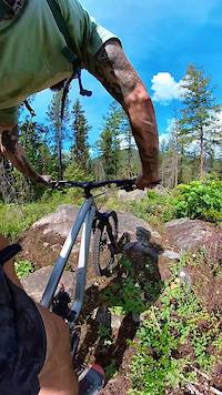
Very steep and technical with lots of rock slabs. A couple of skinnies are thrown in after you dive into the second half. Take caution as once you get to the bottom of the first rock slab there is no turning back It gets harder in the second half. Definitely deserves its double black rating.

Local Trail Association

Recent Activity on Trail

Past Week
  • 0 rides
  •  
6 Months
  • 0 rides
  •  
All
  • 28 rides
  • Last: Jun 24, 2026
c1c2c3c4
January
February
March
April
May
June
July
August
September
October
November
December
update trails status or condition

Yellow Submarine Trail Reports

statusdatedescription
May 23, 2026 @ 10:16am (America/Vancouver)
May 23, 2026
reporter The KCTS trail crew completed seasonal inspection and maintenance.
Jun 2, 2025 @ 6:36pm
Jun 2, 2025
Multiple trees down
Jul 24, 2024 @ 6:52pm
Jul 24, 2024
Running good
May 23, 2024 @ 3:28pm
May 23, 2024
reporter Seasonal maintenance has been completed by the KCTS trail crew. The "skinny" half way down is done. Still as gnarly as ever.
Jul 9, 2022 @ 11:42am
Jul 9, 2022
Rarely ridden, rain rut, fall line snack Go slow bro
more »
Status:
on May 23, 2026
Ideal
Avg: 3.89 (4 votes)
Your vote: 0

view (269)
close
3D
Trail Conditions
  • Unknown
  • Snow Groomed
  • Snow Packed
  • Snow Covered
  • Snow Cover Partial
  • Freeze/thaw Cycle
  • Icy
  • Prevalent Mud
  • Wet
  • Variable
  • Ideal
  • Dry
  • Very Dry
Trail Flow (Ridden Direction)
Trailforks scans users ridelogs to determine the most popular direction each trail is ridden. A good flowing trail network will have most trails flowing in a single direction according to their intension.
The colour categories are based on what percentage of riders are riding a trail in its intended direction.
  • > 96%
  • > 90%
  • > 80%
  • > 70%
  • > 50%
  • < 50%
  • bi-directional trail
  • no data
Trail Last Ridden
Trailforks scans ridelogs to determine the last time a trail was ridden.
  • < 2 days
  • < 1 week
  • < 2 weeks
  • < 1 month
  • < 6 months
  • > 6 months
Trail Ridden Direction
The intended direction a trail should be ridden.
  • Downhill Only
  • Downhill Primary
  • Both Directions
  • Uphill Primary
  • Uphill Only
  • One Direction
Contribute Details
Colors indicate trail is missing specified detail.
  • Description
  • Photos
  • Description & Photos
  • Videos
Trail Popularity ?
Trailforks scans ridelogs to determine which trails are ridden the most in the last 9 months. Trails are compared with nearby trails in the same city region with a possible 25 colour shades. Think of this as a heatmap, more rides = more kinetic energy = warmer colors.
  • most popular
  • popular
  • less popular
  • not popular
ATV/ORV/OHV Filter
Max Vehicle Width
inches
US Cell Coverage
Legend
cell carrier legend

Radar Time
Activity Recordings
Trailforks uses anonymized public activity data. ?
Activity Recordings
Trailforks uses anonymized public activity data. ?
Personal Heatmap
Activity Types
all / none
Options
2
Date range month
Winter Trails
Warning A routing network for winter maps does not exist. Selecting trails using the winter trails layer has been disabled.
Missing Trails
Most Popular
Least Popular
Trails are colored based on popularity. The more popular a trail is, the more red. Less popular trails trend towards green.
Jump Magnitude Heatmap
Heatmap of where riders jump on trails. Zoom in to see individual jumps, click circles to view jump details.
BC Backroad Status

Service Road Atlas is a free to use, community-driven service for viewing and creating reports on the numerous back-country service roads around B.C. and Alberta.

map legend
Slope Aspect
Direction the slope faces
Flat N NE E SE S SW W NW
Trails Deemphasized
Trails are shown in grey.
disable
Only show trails with no bike usage.
Enable
Suggested Layers
Based on selected activity type

    Save the current map location and zoom level as your default home location whenever this page is loaded.

    Save
        Directions to yellow-submarine trailhead (49.091340, -117.798750)

        Photos

        14 more »
        147 |
        Oct 6, 2021 @ 8:16pm
        Oct 6, 2021
        176 |
        Jun 1, 2020 @ 10:14pm
        Jun 1, 2020
        163 |
        Jun 1, 2020 @ 10:14pm
        Jun 1, 2020
        224 |
        Jun 17, 2016 @ 8:03pm
        Jun 17, 2016

        Videos

        1 more »
        First Time Riding Yellow Submarine
        0:52 | 334 | Jun 30, 2023 , Rossland

        Routes with this trail

        12 miles 2,061 ft 22
        Big Loop around the backside of KC, down to Warfield and grind back up the Wagon Road

        1 Review & Comments


        We hope you've been enjoying Trailforks!

        Create a FREE account to view trail comments and much more.

        • By canadakaTF Pro Trailforks & contributors
        • #2163 - 3,377 views

        Frequently Asked Questions About Yellow Submarine

        Where is Yellow Submarine located?
        Yellow Submarine is located in Monte Christo - KC, Rossland, British Columbia, Canada. It is part of the Monte Christo - KC trail network. The trailhead is located at coordinates 49.09134, -117.79875.
        How hard is Yellow Submarine?
        Yellow Submarine is rated as Double Black Diamond difficulty. The physical rating is Easy. The average grade is 28.563%.
        What is the elevation gain for Yellow Submarine?
        The trail has 117 m of elevation descent. The elevation ranges from 1,156 m to 1,274 m.
        Is Yellow Submarine a point to point trail?
        Yes, Yellow Submarine is a point to point trail. The direction is Downhill Only. The trail type is singletrack.

        Hit the Trail

        Open in App

        Get this trail on your phone instantly.
        open trail in app

        Download Trail

        Save to wishlist, Garmin & download.
        save the trail

        Find Related Routes

        Find routes and users activities that include this trail.
        find routes for this trail

        You must enter a description before submitting.