more stats
2,454 ft
Distance
-263 ft
Descent
00:02:48
Avg time
-263 ft
Altitude change
1,491 ft
Altitude min
1,754 ft
Altitude max
1,754 ft
Altitude start
1,493 ft
Altitude end
-10.7%
Grade
-29%
Grade max
-1.8%
Grade min
2,359 ft
Distance down
95 ft
Distance flat
00:02:48
Avg time

Yellow Viper Details

  • Activities
    • Mountain Bike
    • E-Bike
  • Riding Area
  • Difficulty Rating
  • Local Popularity
    15 in Mountain Biking [+]
    • 30 in E-Biking
  • Global Ranking
    #123781 in Mountain Biking [+]
    • #102477 in E-Biking
  • Trail Type
    Singletrack
  • Bike Type
    AM, XC
  • Direction
    Downhill Only
    Popular Direction Shown
  • Dogs Allowed
    Yes
  • eBike Allowed

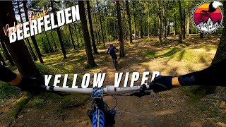
Der 2012 gebaute Yellow Viper ist ein Super-Enduro-Trail, der mit seinen steilen Passagen, enge Kurven, flowigen Abfahrten und kleinen Pedalierstücke alles bietet, was ein Enduro-Biker sich wünscht.

Der Yellow Viper beginnt wie alle Strecken am Starthügel und erstreckt sich anfangs parallel zur Green Bomb Line.

Zum Abschluss wird man über 2 Highspeed Steilkurven zur Dirtline geführt.

Bike Park

Recent Activity on Trail

Past Week
  • 0 rides
  •  
6 Months
  • 19 rides
  • 14 miles avg distance
All
  • 79 rides
  • Last: Jun 20, 2026
c1c2c3c4
January
February
March
April
May
June
July
August
September
October
November
December
Status:
on Dec 30, 2024
Freeze/thaw Cycle
Avg: 3.88 (3 votes)
Your vote: 0

view (1,130)
close
3D
Trail Conditions
  • Unknown
  • Snow Groomed
  • Snow Packed
  • Snow Covered
  • Snow Cover Partial
  • Freeze/thaw Cycle
  • Icy
  • Prevalent Mud
  • Wet
  • Variable
  • Ideal
  • Dry
  • Very Dry
Trail Flow (Ridden Direction)
Trailforks scans users ridelogs to determine the most popular direction each trail is ridden. A good flowing trail network will have most trails flowing in a single direction according to their intension.
The colour categories are based on what percentage of riders are riding a trail in its intended direction.
  • > 96%
  • > 90%
  • > 80%
  • > 70%
  • > 50%
  • < 50%
  • bi-directional trail
  • no data
Trail Last Ridden
Trailforks scans ridelogs to determine the last time a trail was ridden.
  • < 2 days
  • < 1 week
  • < 2 weeks
  • < 1 month
  • < 6 months
  • > 6 months
Trail Ridden Direction
The intended direction a trail should be ridden.
  • Downhill Only
  • Downhill Primary
  • Both Directions
  • Uphill Primary
  • Uphill Only
  • One Direction
Contribute Details
Colors indicate trail is missing specified detail.
  • Description
  • Photos
  • Description & Photos
  • Videos
Trail Popularity ?
Trailforks scans ridelogs to determine which trails are ridden the most in the last 9 months. Trails are compared with nearby trails in the same city region with a possible 25 colour shades. Think of this as a heatmap, more rides = more kinetic energy = warmer colors.
  • most popular
  • popular
  • less popular
  • not popular
ATV/ORV/OHV Filter
Max Vehicle Width
inches
US Cell Coverage
Legend
cell carrier legend

Radar Time
Activity Recordings
Trailforks uses anonymized public activity data. ?
Activity Recordings
Trailforks uses anonymized public activity data. ?
Personal Heatmap
Activity Types
all / none
Options
2
Date range month
Winter Trails
Warning A routing network for winter maps does not exist. Selecting trails using the winter trails layer has been disabled.
Missing Trails
Most Popular
Least Popular
Trails are colored based on popularity. The more popular a trail is, the more red. Less popular trails trend towards green.
Jump Magnitude Heatmap
Heatmap of where riders jump on trails. Zoom in to see individual jumps, click circles to view jump details.
BC Backroad Status

Service Road Atlas is a free to use, community-driven service for viewing and creating reports on the numerous back-country service roads around B.C. and Alberta.

map legend
Slope Aspect
Direction the slope faces
Flat N NE E SE S SW W NW
Trails Deemphasized
Trails are shown in grey.
disable
Only show trails with no bike usage.
Enable
Suggested Layers
Based on selected activity type

    Save the current map location and zoom level as your default home location whenever this page is loaded.

    Save
        Directions to yellow-viper trailhead (49.559940, 8.993820)

        Photos

        No photos have been added for Yellow Viper yet, add a photo.

        Videos

        2 more »
        Yellow Viper
        3:03 | 183 | May 23, 2022 , Oberzent
        youtuber Bikepark Beerfelden - yellow viper -gopro session-
        2:12 | 554 | Jun 17, 2018 , Oberzent

        Reviews / Comments

        No reviews yet, be the first to write a review or ask a question.
        Use trail reports to comment on trail conditions.


        We hope you've been enjoying Trailforks!

        Create a FREE account to view trail comments and much more.

        • By bikrboy38 & contributors
        • #87852 - 1,199 views

        Frequently Asked Questions About Yellow Viper

        Where is Yellow Viper located?
        Yellow Viper is located in Bikepark Beerfelden, Oberzent, Germany. It is part of the Bikepark Beerfelden trail network. The trailhead is located at coordinates 49.55994, 8.99382.
        How hard is Yellow Viper?
        Yellow Viper is rated as Blue difficulty. The average grade is 10.7%.
        What is the elevation gain for Yellow Viper?
        The trail has 263 ft of elevation descent. The elevation ranges from 1,491 ft to 1,754 ft.
        Is Yellow Viper a point to point trail?
        Yes, Yellow Viper is a point to point trail. The direction is Downhill Only. The trail type is singletrack.

        Hit the Trail

        Open in App

        Get this trail on your phone instantly.
        open trail in app

        Download Trail

        Save to wishlist, Garmin & download.
        save the trail

        Find Related Routes

        Find routes and users activities that include this trail.
        find routes for this trail

        You must enter a description before submitting.