more stats
1,529 ft
Distance
19 ft
Climb
-393 ft
Descent
00:06:33
Avg time
-374 ft
Altitude change
903 ft
Altitude min
1,277 ft
Altitude max
1,277 ft
Altitude start
902 ft
Altitude end
-24.5%
Grade
-56.2%
Grade max
21.1%
Grade min
144 ft
Distance climb
1,362 ft
Distance down
23 ft
Distance flat
00:06:33
Avg time

Yer Sister Details

  • Activities
    • Mountain Bike
    • E-Bike
  • Riding Area
    Diamond Head
    Squamish, British Columbia
  • Difficulty Rating
  • Voted Difficulty
    Double Black Diamond (2 votes)
  • Local Popularity
    50 in Mountain Biking [+]
    • 60 in E-Biking
  • Global Ranking
    #94660 in Mountain Biking [+]
    • #65072 in E-Biking
  • Trail Type
    Singletrack
  • Bike Type
    AM
  • Direction
    Downhill Only
    Popular Direction Shown
  • Dogs Allowed
    Yes
  • eBike Allowed
    Yes up to Class 1
  • TTFs on Trail
    Log Ride

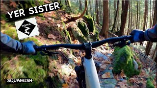
Step into the time machine and relive some old-school jank. Purposely built to counteract the more sanitized flow trails in the area, Yer Sister offers a more precise slow-tech experience as opposed to Your Mom and Deliverance. Check your speed when you get into the open hydro cut - it's looser than you think This trail holds up very well in the wet.

Local Trail Association
Traditionally Indigenous Territory

Recent Activity on Trail

Past Week
  • 0 rides
  •  
6 Months
  • 7 rides
  • 8 miles avg distance
All
  • 161 rides
  • Last: Jun 10, 2026
c1c2c3c4
January
February
March
April
May
June
July
August
September
October
November
December
update trails status or condition

Yer Sister Trail Reports

statusdatedescription
Apr 27, 2026 @ 6:49pm (America/Vancouver)
Apr 27, 2026
decking on the big features towards the bottom is starting to fail, two planks loose on the first big decked cedar log
Mar 19, 2026 @ 7:08pm (America/Vancouver)
Mar 19, 2026
Jan 18, 2026 @ 3:26pm (America/Vancouver)
Jan 18, 2026
Large tree down on the first mellow bench
Dec 21, 2025 @ 1:18pm (America/Vancouver)
Dec 21, 2025
Tree down
Aug 4, 2025 @ 1:56pm
Aug 4, 2025
more »
Status:
on Apr 27, 2026
Dry
Avg: 4.05 (13 votes)
Your vote: 0

view (1,161)
close
3D
Trail Conditions
  • Unknown
  • Snow Groomed
  • Snow Packed
  • Snow Covered
  • Snow Cover Partial
  • Freeze/thaw Cycle
  • Icy
  • Prevalent Mud
  • Wet
  • Variable
  • Ideal
  • Dry
  • Very Dry
Trail Flow (Ridden Direction)
Trailforks scans users ridelogs to determine the most popular direction each trail is ridden. A good flowing trail network will have most trails flowing in a single direction according to their intension.
The colour categories are based on what percentage of riders are riding a trail in its intended direction.
  • > 96%
  • > 90%
  • > 80%
  • > 70%
  • > 50%
  • < 50%
  • bi-directional trail
  • no data
Trail Last Ridden
Trailforks scans ridelogs to determine the last time a trail was ridden.
  • < 2 days
  • < 1 week
  • < 2 weeks
  • < 1 month
  • < 6 months
  • > 6 months
Trail Ridden Direction
The intended direction a trail should be ridden.
  • Downhill Only
  • Downhill Primary
  • Both Directions
  • Uphill Primary
  • Uphill Only
  • One Direction
Contribute Details
Colors indicate trail is missing specified detail.
  • Description
  • Photos
  • Description & Photos
  • Videos
Trail Popularity ?
Trailforks scans ridelogs to determine which trails are ridden the most in the last 9 months. Trails are compared with nearby trails in the same city region with a possible 25 colour shades. Think of this as a heatmap, more rides = more kinetic energy = warmer colors.
  • most popular
  • popular
  • less popular
  • not popular
ATV/ORV/OHV Filter
Max Vehicle Width
inches
US Cell Coverage
Legend
cell carrier legend

Radar Time
Activity Recordings
Trailforks uses anonymized public activity data. ?
Activity Recordings
Trailforks uses anonymized public activity data. ?
Personal Heatmap
Activity Types
all / none
Options
2
Date range month
Winter Trails
Warning A routing network for winter maps does not exist. Selecting trails using the winter trails layer has been disabled.
Missing Trails
Most Popular
Least Popular
Trails are colored based on popularity. The more popular a trail is, the more red. Less popular trails trend towards green.
Jump Magnitude Heatmap
Heatmap of where riders jump on trails. Zoom in to see individual jumps, click circles to view jump details.
BC Backroad Status

Service Road Atlas is a free to use, community-driven service for viewing and creating reports on the numerous back-country service roads around B.C. and Alberta.

map legend
Slope Aspect
Direction the slope faces
Flat N NE E SE S SW W NW
Trails Deemphasized
Trails are shown in grey.
disable
Only show trails with no bike usage.
Enable
Suggested Layers
Based on selected activity type

    Save the current map location and zoom level as your default home location whenever this page is loaded.

    Save
        Directions to yer-sister trailhead (49.745970, -123.089310)

        Photos

        28 more »
        77 |
        Jun 14, 2024 @ 10:13pm
        Jun 14, 2024
        75 |
        Nov 27, 2023 @ 10:59pm
        Nov 27, 2023
        196 |
        Oct 1, 2020 @ 8:00pm
        Oct 1, 2020
        198 |
        Oct 1, 2020 @ 8:00pm
        Oct 1, 2020

        Videos

        1 more »
        youtuber YER SISTER | Black trail | Squamish - University
        3:00 | 195 | Dec 28, 2023 , Squamish

        Routes with this trail

        3 miles 751 ft 6
        Legacy Climb > Ring Creek Access Road > Doubletrack > > Lower Ditch Pig > Ring Creek Access...
        9 miles 2,637 ft 16
        Legacy Climb > > > > > > > > > > > >

        8 Reviews & Comments


        We hope you've been enjoying Trailforks!

        Create a FREE account to view trail comments and much more.

        Nearby Trails

        • By canadakaTF Pro Trailforks & contributors
        • #33447 - 3,559 views

        Frequently Asked Questions About Yer Sister

        Where is Yer Sister located?
        Yer Sister is located in Diamond Head, Squamish, British Columbia, Canada. It is part of the Diamond Head trail network. The trailhead is located at coordinates 49.74597, -123.08931.
        How hard is Yer Sister?
        Yer Sister is rated as Black Diamond difficulty. The average grade is 24.5%.
        What is the elevation gain for Yer Sister?
        Yer Sister has 19 ft of elevation gain. The trail has 393 ft of elevation descent. The elevation ranges from 903 ft to 1,277 ft.
        Is Yer Sister a point to point trail?
        Yes, Yer Sister is a point to point trail. The direction is Downhill Only. The trail type is singletrack.

        Hit the Trail

        Open in App

        Get this trail on your phone instantly.
        open trail in app

        Download Trail

        Save to wishlist, Garmin & download.
        save the trail

        Find Related Routes

        Find routes and users activities that include this trail.
        find routes for this trail

        You must enter a description before submitting.