more stats
2,223 ft
Distance
8 ft
Climb
-87 ft
Descent
00:02:28
Avg time
-79 ft
Altitude change
757 ft
Altitude min
837 ft
Altitude max
837 ft
Altitude start
758 ft
Altitude end
-11.331%
Grade max
4.356%
Grade min
235 ft
Distance climb
1,332 ft
Distance down
628 ft
Distance flat
00:02:28
Avg time

Yogurt Pots Details

  • Activities
    • Mountain Bike
    • Hike
    • Trail Running
  • Riding Area
    Surrey Hills
    Dorking
  • Difficulty Rating
  • Local Popularity
    100 in Mountain Biking [+]
    • 55 in Trail Running
    • 5 in Hiking
  • Global Ranking
    #177 in Mountain Biking [+]
    • #61772 in Trail Running
    • #1371 in Hiking
  • Trail Type
    Singletrack
  • Bike Type
    AM, XC
  • Direction
    Both Directions
    Popular Direction Shown
  • Climb Difficulty
    Green
  • Physical Rating
    Easy
  • Season
    Feb-Oct
  • Dogs Allowed
    Yes
  • eBike Allowed
    Yes up to Class 1
  • TTFs on Trail
    Roller Coaster
  • Land Owner

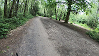
Up's and Down's all the way (like dropping into Yogurt Pots...) with a few berms thrown in. Not the best when very muddy but a great challenge and must visit trail in Surrey Hills

Access Info

From the top of Holmbury Hill Point, turn around and ride down the main path a little way, entrance is on the right.

Local Trail Association

Recent Activity on Trail

Past Week
  • 9 rides
  • 18 miles average
6 Months
  • 173 rides
  • 15 miles avg distance
All
  • 1,842 rides
  • Last: Jun 16, 2026
c1c2c3c4
January
February
March
April
May
June
July
August
September
October
November
December
update trails status or condition

Yogurt Pots Trail Reports

Status:
on Jun 9, 2026
Wet
Avg: 4.3 (34 votes)
Your vote: 0

view (19,648)
close
3D
Trail Conditions
  • Unknown
  • Snow Groomed
  • Snow Packed
  • Snow Covered
  • Snow Cover Partial
  • Freeze/thaw Cycle
  • Icy
  • Prevalent Mud
  • Wet
  • Variable
  • Ideal
  • Dry
  • Very Dry
Trail Flow (Ridden Direction)
Trailforks scans users ridelogs to determine the most popular direction each trail is ridden. A good flowing trail network will have most trails flowing in a single direction according to their intension.
The colour categories are based on what percentage of riders are riding a trail in its intended direction.
  • > 96%
  • > 90%
  • > 80%
  • > 70%
  • > 50%
  • < 50%
  • bi-directional trail
  • no data
Trail Last Ridden
Trailforks scans ridelogs to determine the last time a trail was ridden.
  • < 2 days
  • < 1 week
  • < 2 weeks
  • < 1 month
  • < 6 months
  • > 6 months
Trail Ridden Direction
The intended direction a trail should be ridden.
  • Downhill Only
  • Downhill Primary
  • Both Directions
  • Uphill Primary
  • Uphill Only
  • One Direction
Contribute Details
Colors indicate trail is missing specified detail.
  • Description
  • Photos
  • Description & Photos
  • Videos
Trail Popularity ?
Trailforks scans ridelogs to determine which trails are ridden the most in the last 9 months. Trails are compared with nearby trails in the same city region with a possible 25 colour shades. Think of this as a heatmap, more rides = more kinetic energy = warmer colors.
  • most popular
  • popular
  • less popular
  • not popular
ATV/ORV/OHV Filter
Max Vehicle Width
inches
US Cell Coverage
Legend
cell carrier legend

Radar Time
Activity Recordings
Trailforks uses anonymized public activity data. ?
Activity Recordings
Trailforks uses anonymized public activity data. ?
Personal Heatmap
Activity Types
all / none
Options
2
Date range month
Winter Trails
Warning A routing network for winter maps does not exist. Selecting trails using the winter trails layer has been disabled.
Missing Trails
Most Popular
Least Popular
Trails are colored based on popularity. The more popular a trail is, the more red. Less popular trails trend towards green.
Jump Magnitude Heatmap
Heatmap of where riders jump on trails. Zoom in to see individual jumps, click circles to view jump details.
BC Backroad Status

Service Road Atlas is a free to use, community-driven service for viewing and creating reports on the numerous back-country service roads around B.C. and Alberta.

map legend
Slope Aspect
Direction the slope faces
Flat N NE E SE S SW W NW
Trails Deemphasized
Trails are shown in grey.
disable
Only show trails with no bike usage.
Enable
Suggested Layers
Based on selected activity type

    Save the current map location and zoom level as your default home location whenever this page is loaded.

    Save
        Directions to yogurt-pots trailhead (51.176460, -0.422610)

        Photos

        2 more »
        232 |
        Oct 10, 2020 @ 8:28am
        Oct 10, 2020
        210 |
        Jul 23, 2020 @ 10:16am
        Jul 23, 2020

        Videos

        5 more »
        T&T Surrey Hills - Yoghurt Pots (with...
        6:30 | 1493 | Jun 10, 2019 , Dorking
        2:14 | 232 | Jun 11, 2022 , Dorking
        SAW productions do Yogurt pots
        2:31 | 296 | Feb 10, 2019 , Dorking
        A Summer shred down Yogurt Pots, Holmbury Hill
        3:52 | 893 | Aug 23, 2011 , Dorking

        Trail Lists

        Routes with this trail

        3.3 18 miles 2,279 ft 13
        A 19 Mile ride around Surrey Hills taking in some of the best bits... including 2 visits to Peaslake...
        2.4 19 miles 1,809 ft 3
        Route from EMTB Forums rideout.
        3.0 12 miles 1,493 ft 7 Loop
        A ride that turned out pretty cool imported from Strava.

        5 Reviews & Comments


        We hope you've been enjoying Trailforks!

        Create a FREE account to view trail comments and much more.

        • By shreddingpeas & contributors
        • #28497 - 10,865 views

        Frequently Asked Questions About Yogurt Pots

        Where is Yogurt Pots located?
        Yogurt Pots is located in Surrey Hills, Dorking, United Kingdom. It is part of the Surrey Hills trail network. The trailhead is located at coordinates 51.17646, -0.42261.
        How hard is Yogurt Pots?
        Yogurt Pots is rated as Blue difficulty. The physical rating is Easy. The climb difficulty is rated Green.
        What is the elevation gain for Yogurt Pots?
        Yogurt Pots has 8 ft of elevation gain. The trail has 87 ft of elevation descent. The elevation ranges from 757 ft to 837 ft.
        Is Yogurt Pots a point to point trail?
        Yogurt Pots is not a point to point trail. The direction is Both Directions. The trail type is singletrack.

        Hit the Trail

        Open in App

        Get this trail on your phone instantly.
        open trail in app

        Download Trail

        Save to wishlist, Garmin & download.
        save the trail

        Find Related Routes

        Find routes and users activities that include this trail.
        find routes for this trail

        You must enter a description before submitting.