more stats
3.1 miles
Distance
2 ft
Climb
-2 ft
Descent
00:21:42
Avg time
0 ft
Altitude change
5 ft
Altitude min
9 ft
Altitude max
9 ft
Altitude start
10 ft
Altitude end
-1.1%
Grade max
0.9%
Grade min
522 ft
Distance climb
440 ft
Distance down
3 miles
Distance flat
00:21:42
Avg time

Z Trail Details

  • Activities
    • Mountain Bike
    • Winter Fat Bike
    • Hike
    • Trail Running
  • Riding Area
    Hanna Park
    Jacksonville, Florida
  • Difficulty Rating
  • Voted Difficulty
    Blue (2 votes)
  • Local Popularity
    80 in Mountain Biking [+]
    • 5 in Trail Running
    • 5 in Hiking
  • Global Ranking
    #81085 in Mountain Biking [+]
    • #131515 in Trail Running
    • #124655 in Hiking
  • Hiking SAC Scale
    T1 Hiking
  • Trail Type
    Singletrack
  • Bike Type
    AM, XC, Fat
  • Direction
    One Direction
  • Climb Difficulty
    Green
  • Physical Rating
    Easy
  • Trail Visibility
    Sometimes hard to follow
  • Dogs Allowed
    Yes
  • Land Owner
    Jacksonville City

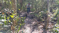
Z Trail is for those who love to test their slow speed balance and technical skills. As the hardest route in Hanna Park, you'll have the book thrown at you.

Tight, twisty sections of singletrack mixed in with quick, punch climbs and descents....this is what you'll find throughout this loop that runs inside of South Loop - Hanna Park

The trail is directional and is ridden clockwise or counter-clockwise depending on the day of the week. It crosses a park road in a couple places, it merges with a green, multi-use trail in one spot and it has a very tight switchback/double-back section at the southern end that can confuse the first time rider.
There are a few bridges and lots of roots to negotiate. There's one tricky wooden feature/bridge concoction that may force a new rider to get off and walk the bike. The bridge is fine, but the wooden feature extending from it doesn't merge naturally with the flow of the trail or the bridge. Most of the trail is tightly packed and smooth, but some portions are sandy and will slow the ride.

Access Info

A fee is required to enter the park.

Local Trail Association
Traditionally Indigenous Territory

Recent Activity on Trail

Past Week
  • 0 rides
  •  
6 Months
  • 52 rides
  • 12 miles avg distance
All
  • 480 rides
  • Last: Jun 7, 2026
c1c2c3c4
January
February
March
April
May
June
July
August
September
October
November
December
update trails status or condition

Z Trail Trail Reports

statusdatedescription
Dec 12, 2025 @ 10:45am (America/Nassau)
Dec 12, 2025
New area added onto Z Trail. Nice!
Nov 29, 2025 @ 4:12pm (America/Nassau)
Nov 29, 2025
Mar 13, 2025 @ 8:35am
Mar 13, 2025
Mar 5, 2023 @ 2:40am
Mar 5, 2023
Jan 19, 2023 @ 10:33am
Jan 19, 2023
Trails are great at Hanna park, but watch out stupid Teachers walking there schoolclasses on the bike trails…. Super scratchy
more »
Status:
on Dec 12, 2025
Dry
Avg: 3.53 (7 votes)
Your vote: 0

view (5,465)
close
3D
Trail Conditions
  • Unknown
  • Snow Groomed
  • Snow Packed
  • Snow Covered
  • Snow Cover Partial
  • Freeze/thaw Cycle
  • Icy
  • Prevalent Mud
  • Wet
  • Variable
  • Ideal
  • Dry
  • Very Dry
Trail Flow (Ridden Direction)
Trailforks scans users ridelogs to determine the most popular direction each trail is ridden. A good flowing trail network will have most trails flowing in a single direction according to their intension.
The colour categories are based on what percentage of riders are riding a trail in its intended direction.
  • > 96%
  • > 90%
  • > 80%
  • > 70%
  • > 50%
  • < 50%
  • bi-directional trail
  • no data
Trail Last Ridden
Trailforks scans ridelogs to determine the last time a trail was ridden.
  • < 2 days
  • < 1 week
  • < 2 weeks
  • < 1 month
  • < 6 months
  • > 6 months
Trail Ridden Direction
The intended direction a trail should be ridden.
  • Downhill Only
  • Downhill Primary
  • Both Directions
  • Uphill Primary
  • Uphill Only
  • One Direction
Contribute Details
Colors indicate trail is missing specified detail.
  • Description
  • Photos
  • Description & Photos
  • Videos
Trail Popularity ?
Trailforks scans ridelogs to determine which trails are ridden the most in the last 9 months. Trails are compared with nearby trails in the same city region with a possible 25 colour shades. Think of this as a heatmap, more rides = more kinetic energy = warmer colors.
  • most popular
  • popular
  • less popular
  • not popular
ATV/ORV/OHV Filter
Max Vehicle Width
inches
US Cell Coverage
Legend
cell carrier legend

Radar Time
Activity Recordings
Trailforks uses anonymized public activity data. ?
Activity Recordings
Trailforks uses anonymized public activity data. ?
Personal Heatmap
Activity Types
all / none
Options
2
Date range month
Winter Trails
Warning A routing network for winter maps does not exist. Selecting trails using the winter trails layer has been disabled.
Missing Trails
Most Popular
Least Popular
Trails are colored based on popularity. The more popular a trail is, the more red. Less popular trails trend towards green.
Jump Magnitude Heatmap
Heatmap of where riders jump on trails. Zoom in to see individual jumps, click circles to view jump details.
BC Backroad Status

Service Road Atlas is a free to use, community-driven service for viewing and creating reports on the numerous back-country service roads around B.C. and Alberta.

map legend
Slope Aspect
Direction the slope faces
Flat N NE E SE S SW W NW
Trails Deemphasized
Trails are shown in grey.
disable
Only show trails with no bike usage.
Enable
Suggested Layers
Based on selected activity type

    Save the current map location and zoom level as your default home location whenever this page is loaded.

    Save
        Directions to z-trail trailhead (30.370800, -81.406080)

        Photos

        8 more »
        402 |
        Jul 29, 2021 @ 9:24pm
        Jul 29, 2021
        538 |
        Jul 29, 2021 @ 9:24pm
        Jul 29, 2021
        439 |
        Jul 29, 2021 @ 9:24pm
        Jul 29, 2021
        461 |
        Jul 29, 2021 @ 9:23pm
        Jul 29, 2021

        Videos

        1 more »
        Front wheel dig
        0:05 | 1132 | Feb 1, 2021 , Jacksonville

        5 Reviews & Comments


        We hope you've been enjoying Trailforks!

        Create a FREE account to view trail comments and much more.

        Frequently Asked Questions About Z Trail

        Where is Z Trail located?
        Z Trail is located in Hanna Park, Jacksonville, Florida, United States. It is part of the Hanna Park trail network. The trailhead is located at coordinates 30.3708, -81.40608.
        How hard is Z Trail?
        Z Trail is rated as Black Diamond difficulty. The physical rating is Easy. The climb difficulty is rated Green.
        What is the elevation gain for Z Trail?
        Z Trail has 2 ft of elevation gain. The trail has 2 ft of elevation descent. The elevation ranges from 5 ft to 9 ft.
        Is Z Trail a point to point trail?
        Yes, Z Trail is a point to point trail. The direction is One Direction. The trail type is singletrack.

        Hit the Trail

        Open in App

        Get this trail on your phone instantly.
        open trail in app

        Download Trail

        Save to wishlist, Garmin & download.
        save the trail

        Find Related Routes

        Find routes and users activities that include this trail.
        find routes for this trail

        You must enter a description before submitting.