more stats
7.0 miles
Distance
167 ft
Climb
-166 ft
Descent
00:40:17
Avg time
1 ft
Altitude change
28 ft
Altitude min
73 ft
Altitude max
72 ft
Altitude start
72 ft
Altitude end
-7.5%
Grade max
7%
Grade min
2 miles
Distance climb
3 miles
Distance down
2 miles
Distance flat
00:40:17
Avg time

Zeist Details

  • Activities
    • Mountain Bike
  • Riding Area
  • Difficulty Rating
  • Local Popularity
    80 in Mountain Biking
  • Global Ranking
    #25530 in Mountain Biking
  • Trail Type
    Singletrack
  • Bike Type
    XC
  • Direction
    One Direction
    Popular Direction Shown
  • Climb Difficulty
    Blue
  • Physical Rating
    Moderate
  • Season
    All season
  • Family Friendly
    Yes
  • Dogs Allowed
    Yes
  • Ride in Rain
    Yes

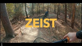
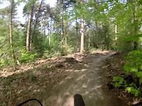
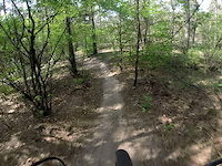
Really physical and technical XC trail, lots of small climbs and descents with technical corners. Last part is flatter so you can make some real speed there. Can be combined with the austerlitz trail.

Access Info

Parking can be done at 't Jagershuys, Jagersingel 15, Zeist.

Recent Activity on Trail

Past Week
  • 4 rides
  • 25 miles average
6 Months
  • 46 rides
  • 22 miles avg distance
All
  • 346 rides
  • Last: Jun 19, 2026
c1c2c3c4
January
February
March
April
May
June
July
August
September
October
November
December
update trails status or condition

Zeist Trail Reports

Status:
on Apr 11, 2026
Dry
Avg: 3.99 (12 votes)
Your vote: 0

view (3,549)
close
3D
Trail Conditions
  • Unknown
  • Snow Groomed
  • Snow Packed
  • Snow Covered
  • Snow Cover Partial
  • Freeze/thaw Cycle
  • Icy
  • Prevalent Mud
  • Wet
  • Variable
  • Ideal
  • Dry
  • Very Dry
Trail Flow (Ridden Direction)
Trailforks scans users ridelogs to determine the most popular direction each trail is ridden. A good flowing trail network will have most trails flowing in a single direction according to their intension.
The colour categories are based on what percentage of riders are riding a trail in its intended direction.
  • > 96%
  • > 90%
  • > 80%
  • > 70%
  • > 50%
  • < 50%
  • bi-directional trail
  • no data
Trail Last Ridden
Trailforks scans ridelogs to determine the last time a trail was ridden.
  • < 2 days
  • < 1 week
  • < 2 weeks
  • < 1 month
  • < 6 months
  • > 6 months
Trail Ridden Direction
The intended direction a trail should be ridden.
  • Downhill Only
  • Downhill Primary
  • Both Directions
  • Uphill Primary
  • Uphill Only
  • One Direction
Contribute Details
Colors indicate trail is missing specified detail.
  • Description
  • Photos
  • Description & Photos
  • Videos
Trail Popularity ?
Trailforks scans ridelogs to determine which trails are ridden the most in the last 9 months. Trails are compared with nearby trails in the same city region with a possible 25 colour shades. Think of this as a heatmap, more rides = more kinetic energy = warmer colors.
  • most popular
  • popular
  • less popular
  • not popular
ATV/ORV/OHV Filter
Max Vehicle Width
inches
US Cell Coverage
Legend
cell carrier legend

Radar Time
Activity Recordings
Trailforks uses anonymized public activity data. ?
Activity Recordings
Trailforks uses anonymized public activity data. ?
Personal Heatmap
Activity Types
all / none
Options
2
Date range month
Winter Trails
Warning A routing network for winter maps does not exist. Selecting trails using the winter trails layer has been disabled.
Missing Trails
Most Popular
Least Popular
Trails are colored based on popularity. The more popular a trail is, the more red. Less popular trails trend towards green.
Jump Magnitude Heatmap
Heatmap of where riders jump on trails. Zoom in to see individual jumps, click circles to view jump details.
BC Backroad Status

Service Road Atlas is a free to use, community-driven service for viewing and creating reports on the numerous back-country service roads around B.C. and Alberta.

map legend
Slope Aspect
Direction the slope faces
Flat N NE E SE S SW W NW
Trails Deemphasized
Trails are shown in grey.
disable
Only show trails with no bike usage.
Enable
Suggested Layers
Based on selected activity type

    Save the current map location and zoom level as your default home location whenever this page is loaded.

    Save
        Directions to zeist trailhead (52.071330, 5.313150)

        Photos

        24 more »
        110 |
        Jul 11, 2025 @ 5:35am
        Jul 11, 2025
        80 |
        Feb 12, 2021 @ 10:14am
        Feb 12, 2021
        92 |
        Feb 12, 2021 @ 10:14am
        Feb 12, 2021
        111 |
        Feb 12, 2021 @ 10:14am
        Feb 12, 2021

        Videos

        8 more »
        youtuber Zeist // MTB Challenge
        7:12 | 174 | Jan 2, 2024 , Zeist
        retro delux
        2:18 | 187 | Mar 10, 2017 , Zeist
        XC amersfoort
        4:22 | 172 | May 12, 2015 , Zeist
        xc holland
        4:15 | 63 | May 12, 2015 , Zeist

        Trail Lists

        Reviews / Comments

        No reviews yet, be the first to write a review or ask a question.
        Use trail reports to comment on trail conditions.


        We hope you've been enjoying Trailforks!

        Create a FREE account to view trail comments and much more.

        • By schralpcc & contributors
        • #9884 - 3,875 views

        Frequently Asked Questions About Zeist

        Where is Zeist located?
        Zeist is located in Zeist, Netherlands. It is part of the Zeist trail network. The trailhead is located at coordinates 52.07133, 5.31315.
        How hard is Zeist?
        Zeist is rated as Green difficulty. The physical rating is Moderate. The climb difficulty is rated Blue.
        What is the elevation gain for Zeist?
        Zeist has 51 m of elevation gain. The trail has 51 m of elevation descent. The elevation ranges from 9 m to 22 m.
        Is Zeist a point to point trail?
        Yes, Zeist is a point to point trail. The direction is One Direction. The trail type is singletrack.

        Hit the Trail

        Open in App

        Get this trail on your phone instantly.
        open trail in app

        Download Trail

        Save to wishlist, Garmin & download.
        save the trail

        Find Related Routes

        Find routes and users activities that include this trail.
        find routes for this trail

        You must enter a description before submitting.