more stats
2.5 miles
Distance
-1,437 ft
Descent
00:17:08
Avg time
-1,437 ft
Altitude change
3,538 ft
Altitude min
4,977 ft
Altitude max
4,975 ft
Altitude start
3,537 ft
Altitude end
-11.1%
Grade
-49.4%
Grade max
4.1%
Grade min
335 ft
Distance climb
2 miles
Distance down
82 ft
Distance flat
00:17:08
Avg time

Z-LINE Details

  • Activities
    • Mountain Bike
    • E-Bike
  • Riding Area
    Bike-Circus - Saalbach Hinterglemm
    Saalbach Hinterglemm
  • Ref Number
    SH44
  • Difficulty Rating
  • Voted Difficulty
    Black Diamond (4 votes)
  • Local Popularity
    90 in Mountain Biking [+]
    • 75 in E-Biking
  • Global Ranking
    #8114 in Mountain Biking [+]
    • #33561 in E-Biking
  • Trail Type
    Machine Groomed
  • Bike Type
    DH, AM
  • Direction
    Downhill Primary
    Popular Direction Shown
  • Physical Rating
    Moderate
  • Trail Visibility
    Always easy to follow
  • eBike Allowed
    Yes up to Class 1
  • TTFs on Trail
    Berm, Bridge, Drop, Jump, Pump Track, Wallride
  • Land Owner

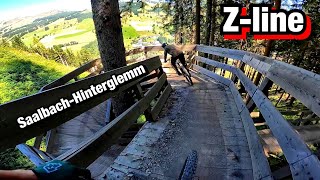
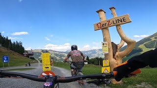
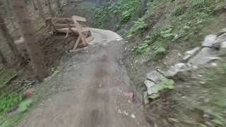
The Z-Line powered by TREK starts right next to the mid station of the Zwölferkogel lift, then snakes its way down to the valley, with breathtaking views over Saalbach Hinterglemm. The route takes you over countless berms, wallrides, and Northshore passages, as well as rollers, tables, and smaller drops. There are always alternative ways around these features for those who might like to take things a little more gently. The last wallride has got to be the real highlight, with its integrated Action-Snapshot-Station, giving you the chance of getting a spectacular souvenir photo. (download of the images on www.saalbach.me)

The route is designed with ambitious freeriders in mind, though tourers with suitable protection and trail experience will also love it. Tip: Just before the end, there is a turning that takes you to the pumptrack and the bike technique training area at the Wieserauberg.

Bike Park

Recent Activity on Trail

Past Week
  • 8 rides
  • 33 miles average
6 Months
  • 36 rides
  • 27 miles avg distance
All
  • 461 rides
  • Last: Jun 17, 2026
c1c2c3c4
January
February
March
April
May
June
July
August
September
October
November
December
update trails status or condition

Z-LINE Trail Reports

Status:
on Sep 11, 2025
Variable
Avg: 3.86 (51 votes)
Your vote: 0

view (4,435)
close
3D
Trail Conditions
  • Unknown
  • Snow Groomed
  • Snow Packed
  • Snow Covered
  • Snow Cover Partial
  • Freeze/thaw Cycle
  • Icy
  • Prevalent Mud
  • Wet
  • Variable
  • Ideal
  • Dry
  • Very Dry
Trail Flow (Ridden Direction)
Trailforks scans users ridelogs to determine the most popular direction each trail is ridden. A good flowing trail network will have most trails flowing in a single direction according to their intension.
The colour categories are based on what percentage of riders are riding a trail in its intended direction.
  • > 96%
  • > 90%
  • > 80%
  • > 70%
  • > 50%
  • < 50%
  • bi-directional trail
  • no data
Trail Last Ridden
Trailforks scans ridelogs to determine the last time a trail was ridden.
  • < 2 days
  • < 1 week
  • < 2 weeks
  • < 1 month
  • < 6 months
  • > 6 months
Trail Ridden Direction
The intended direction a trail should be ridden.
  • Downhill Only
  • Downhill Primary
  • Both Directions
  • Uphill Primary
  • Uphill Only
  • One Direction
Contribute Details
Colors indicate trail is missing specified detail.
  • Description
  • Photos
  • Description & Photos
  • Videos
Trail Popularity ?
Trailforks scans ridelogs to determine which trails are ridden the most in the last 9 months. Trails are compared with nearby trails in the same city region with a possible 25 colour shades. Think of this as a heatmap, more rides = more kinetic energy = warmer colors.
  • most popular
  • popular
  • less popular
  • not popular
ATV/ORV/OHV Filter
Max Vehicle Width
inches
US Cell Coverage
Legend
cell carrier legend

Radar Time
Activity Recordings
Trailforks uses anonymized public activity data. ?
Activity Recordings
Trailforks uses anonymized public activity data. ?
Personal Heatmap
Activity Types
all / none
Options
2
Date range month
Winter Trails
Warning A routing network for winter maps does not exist. Selecting trails using the winter trails layer has been disabled.
Missing Trails
Most Popular
Least Popular
Trails are colored based on popularity. The more popular a trail is, the more red. Less popular trails trend towards green.
Jump Magnitude Heatmap
Heatmap of where riders jump on trails. Zoom in to see individual jumps, click circles to view jump details.
BC Backroad Status

Service Road Atlas is a free to use, community-driven service for viewing and creating reports on the numerous back-country service roads around B.C. and Alberta.

map legend
Slope Aspect
Direction the slope faces
Flat N NE E SE S SW W NW
Trails Deemphasized
Trails are shown in grey.
disable
Only show trails with no bike usage.
Enable
Suggested Layers
Based on selected activity type

    Save the current map location and zoom level as your default home location whenever this page is loaded.

    Save
        Directions to zline trailhead (47.363580, 12.581740)

        Photos

        37 more »
        61 |
        Sep 15, 2024 @ 9:08am
        Sep 15, 2024
        50 |
        Aug 24, 2024 @ 8:48am
        Aug 24, 2024
        168 |
        Sep 14, 2020 @ 12:20pm
        Sep 14, 2020
        165 |
        Sep 14, 2020 @ 12:20pm
        Sep 14, 2020

        Videos

        29 more »
        New Z-Line trail in Saalbach-Hinterglemm. Full...
        12:48 | 87 | Sep 9, 2025 , Saalbach Hinterglemm
        youtuber Z-Line MTB Trail | Red-Grade Fast Flow Fun in...
        10:19 | 85 | Aug 18, 2025 , Saalbach Hinterglemm
        youtuber INSANE CRASH and SKETCHY Riding in the...
        18:54 | 259 | Aug 23, 2022 , Saalbach Hinterglemm
        Z-Line | Bike Park Saalbach-Hinterglemm 2022
        11:20 | 283 | Aug 19, 2022 , Saalbach Hinterglemm

        Routes with this trail

        4.5 38 miles 12,614 ft 14 Loop
        Die BIG-5 Bike Challenge vereint sechs Seilbahnen und fünf Berge rund um Saalbach Hinterglemm und Leogang...
        2.0 57 miles 16,295 ft 12 Loop
        Dank moderner Bergbahnen ist das an einem Tag zu schaffen! Stellt euch dabei auf pure Trailfreuden in...

        3 Reviews & Comments


        We hope you've been enjoying Trailforks!

        Create a FREE account to view trail comments and much more.

        Frequently Asked Questions About Z-LINE

        Where is Z-LINE located?
        Z-LINE is located in Bike-Circus - Saalbach Hinterglemm, Saalbach Hinterglemm, Austria. It is part of the Bike-Circus - Saalbach Hinterglemm trail network. The trailhead is located at coordinates 47.36358, 12.58174.
        How hard is Z-LINE?
        Z-LINE is rated as Red difficulty. The physical rating is Moderate. The average grade is 11.1%.
        What is the elevation gain for Z-LINE?
        The trail has 438 m of elevation descent. The elevation ranges from 1,078 m to 1,517 m.
        Is Z-LINE a point to point trail?
        Z-LINE is not a point to point trail. The direction is Downhill Primary. The trail type is machine groomed.

        Hit the Trail

        Open in App

        Get this trail on your phone instantly.
        open trail in app

        Download Trail

        Save to wishlist, Garmin & download.
        save the trail

        Find Related Routes

        Find routes and users activities that include this trail.
        find routes for this trail

        You must enter a description before submitting.