more stats
1.6 miles
Distance
8 ft
Climb
-1,410 ft
Descent
00:15:48
Avg time
-1,402 ft
Altitude change
3,286 ft
Altitude min
4,687 ft
Altitude max
4,687 ft
Altitude start
3,287 ft
Altitude end
-16.5%
Grade
-105.3%
Grade max
6.3%
Grade min
423 ft
Distance climb
2 miles
Distance down
59 ft
Distance flat
00:15:48
Avg time

Zolles Details

  • Activities
    • Mountain Bike
    • E-Bike
    • Hike
    • Trail Running
  • Riding Area
  • Difficulty Rating
  • Local Popularity
    90 in Mountain Biking [+]
    • 90 in E-Biking
    • 5 in Trail Running
    • 5 in Hiking
  • Global Ranking
    #2033 in Mountain Biking [+]
    • #23924 in E-Biking
    • #134740 in Trail Running
    • #128183 in Hiking
  • Hiking SAC Scale
    T2 Mountain Hiking
  • Trail Type
    Singletrack
  • Bike Type
    AM, XC, Fat
  • Direction
    Downhill Primary
  • Physical Rating
    Moderate
  • Trail Visibility
    Always easy to follow
  • Season
    Todo el año
  • Dogs Allowed
    Yes
  • eBike Allowed
    Yes up to Class 1
  • Ride in Rain
    Yes

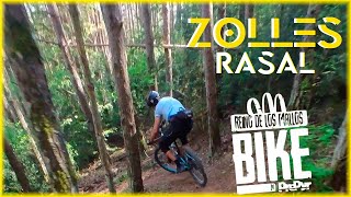
Sendero con mucho Flow que nos conducirá al fonde del valle de Rasal entre bonitos pinares. Técnicamente podriamos dividir en tres partes, superior la entrada sencilla para luego zona de curvas enlazadas con pendiente pero sanas, sin escalones, tramo intermedio muy rápido con buen grip, ytramo final con curvas mas sencilas que primera parte.

Recent Activity on Trail

Past Week
  • 0 rides
  •  
6 Months
  • 1 rides
  • 26.6 km avg distance
All
  • 36 rides
  • Last: May 30, 2026
c1c2c3c4
January
February
March
April
May
June
July
August
September
October
November
December
update trails status or condition

Zolles Trail Reports

statusdatedescription
Jun 23, 2026 @ 4:08pm (Europe/Andorra)
1 day
Senda algo vestida de vegetación y con miles de piñas que hacen que patinen mucho las ruedas
May 30, 2026 @ 10:04am (Europe/Andorra)
May 30, 2026
Apr 25, 2025 @ 9:37am
Apr 25, 2025
Perfecta ya sin árboles
Mar 19, 2025 @ 12:35am
Mar 19, 2025
En perfectas condiciones, algun arbol caido pero se puede pasar sin desmontar
Dec 21, 2024 @ 2:47am
Dec 21, 2024
árbol caido
more »
Status:
on Jun 23, 2026
Dry
Avg: 4.53 (8 votes)
Your vote: 0

view (215)
close
3D
Trail Conditions
  • Unknown
  • Snow Groomed
  • Snow Packed
  • Snow Covered
  • Snow Cover Partial
  • Freeze/thaw Cycle
  • Icy
  • Prevalent Mud
  • Wet
  • Variable
  • Ideal
  • Dry
  • Very Dry
Trail Flow (Ridden Direction)
Trailforks scans users ridelogs to determine the most popular direction each trail is ridden. A good flowing trail network will have most trails flowing in a single direction according to their intension.
The colour categories are based on what percentage of riders are riding a trail in its intended direction.
  • > 96%
  • > 90%
  • > 80%
  • > 70%
  • > 50%
  • < 50%
  • bi-directional trail
  • no data
Trail Last Ridden
Trailforks scans ridelogs to determine the last time a trail was ridden.
  • < 2 days
  • < 1 week
  • < 2 weeks
  • < 1 month
  • < 6 months
  • > 6 months
Trail Ridden Direction
The intended direction a trail should be ridden.
  • Downhill Only
  • Downhill Primary
  • Both Directions
  • Uphill Primary
  • Uphill Only
  • One Direction
Contribute Details
Colors indicate trail is missing specified detail.
  • Description
  • Photos
  • Description & Photos
  • Videos
Trail Popularity ?
Trailforks scans ridelogs to determine which trails are ridden the most in the last 9 months. Trails are compared with nearby trails in the same city region with a possible 25 colour shades. Think of this as a heatmap, more rides = more kinetic energy = warmer colors.
  • most popular
  • popular
  • less popular
  • not popular
ATV/ORV/OHV Filter
Max Vehicle Width
inches
US Cell Coverage
Legend
cell carrier legend

Radar Time
Activity Recordings
Trailforks uses anonymized public activity data. ?
Activity Recordings
Trailforks uses anonymized public activity data. ?
Personal Heatmap
Activity Types
all / none
Options
2
Date range month
Winter Trails
Warning A routing network for winter maps does not exist. Selecting trails using the winter trails layer has been disabled.
Missing Trails
Most Popular
Least Popular
Trails are colored based on popularity. The more popular a trail is, the more red. Less popular trails trend towards green.
Jump Magnitude Heatmap
Heatmap of where riders jump on trails. Zoom in to see individual jumps, click circles to view jump details.
BC Backroad Status

Service Road Atlas is a free to use, community-driven service for viewing and creating reports on the numerous back-country service roads around B.C. and Alberta.

map legend
Slope Aspect
Direction the slope faces
Flat N NE E SE S SW W NW
Trails Deemphasized
Trails are shown in grey.
disable
Only show trails with no bike usage.
Enable
Suggested Layers
Based on selected activity type

    Save the current map location and zoom level as your default home location whenever this page is loaded.

    Save
        Directions to zolles trailhead (42.339360, -0.574630)

        Photos

        24 more »
        43 |
        May 19, 2023 @ 12:18pm
        May 19, 2023
        29 |
        Mar 19, 2025 @ 12:39am
        Mar 19, 2025
        20 |
        Mar 19, 2025 @ 12:39am
        Mar 19, 2025
        23 |
        Mar 19, 2025 @ 12:39am
        Mar 19, 2025

        Videos

        1 more »
        Rasal Zolles  De los mejores senderos...Del país?
        13:52 | 108 | Jun 18, 2024 , Ayerbe

        Routes with this trail

        16 miles 4,683 ft 11
        de Loarre a Rasal por Virgen de los Ríos con regreso subiendo al Pusilibro

        3 Reviews & Comments


        We hope you've been enjoying Trailforks!

        Create a FREE account to view trail comments and much more.

        • By LimonerasTF Pro TFSPAIN & contributors
        • #509115 - 658 views

        Frequently Asked Questions About Zolles

        Where is Zolles located?
        Zolles is located in Reino de los Mallos Bike, Ayerbe, Spain. It is part of the Reino de los Mallos Bike trail network. The trailhead is located at coordinates 42.33936, -0.57463.
        How hard is Zolles?
        Zolles is rated as Blue difficulty. The physical rating is Moderate. The average grade is 16.5%.
        What is the elevation gain for Zolles?
        Zolles has 8 ft of elevation gain. The trail has 1,410 ft of elevation descent. The elevation ranges from 3,286 ft to 4,687 ft.
        Is Zolles a point to point trail?
        Zolles is not a point to point trail. The direction is Downhill Primary. The trail type is singletrack.

        Hit the Trail

        Open in App

        Get this trail on your phone instantly.
        open trail in app

        Download Trail

        Save to wishlist, Garmin & download.
        save the trail

        Find Related Routes

        Find routes and users activities that include this trail.
        find routes for this trail

        You must enter a description before submitting.