more stats
3.6 miles
Distance
289 ft
Climb
-368 ft
Descent
00:30:30
Avg time
-79 ft
Altitude change
469 ft
Altitude min
645 ft
Altitude max
553 ft
Altitude start
476 ft
Altitude end
-0.4%
Grade
-21.1%
Grade max
37.2%
Grade min
2 miles
Distance climb
2 miles
Distance down
2,822 ft
Distance flat
00:30:30
Avg time

Zombie West Details

  • Activities
    • Mountain Bike
    • E-Bike
    • Hike
    • Trail Running
  • Riding Area
    Rock Hollow
    Wildwood, Missouri
  • AKA
    Rock Hollow (Natural Surface)
  • Difficulty Rating
  • Voted Difficulty
    Blue (3 votes)
  • Local Popularity
    60 in Mountain Biking [+]
    • 70 in E-Biking
    • 70 in Trail Running
    • 55 in Hiking
  • Global Ranking
    #7623 in Mountain Biking [+]
    • #78152 in Trail Running
    • #37304 in Hiking
  • Hiking SAC Scale
    T3 Demanding Mountain Hiking
  • Trail Type
    Singletrack
  • Bike Type
    AM, XC
  • Direction
    Both Directions
    Popular Direction Shown
  • Climb Difficulty
    Blue
  • Physical Rating
    Moderate
  • Trail Visibility
    Always easy to follow
  • Season
    Year round
  • Dogs Allowed
    Yes
  • eBike Allowed
    Yes up to Class 1
  • TTFs on Trail
    Berm, Drop, Jump, Rock Garden, Roller Coaster

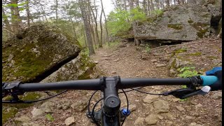
The western half of the Zombie Trail is now complete and can be accessed from the Rock Hollow paved trail. Switchbacking you up through, under and around spectacular rock formations Zombie weaves in and out of multiple hollows and eventually leads you back to the pavement. This is the less gnarly side of Zombie and now contains a small jump line finishing with a huge rock tabletop.

Local Trail Association

Recent Activity on Trail

Past Week
  • 0 rides
  •  
6 Months
  • 55 rides
  • 11 miles avg distance
All
  • 571 rides
  • Last: Jun 7, 2026
c1c2c3c4
January
February
March
April
May
June
July
August
September
October
November
December
update trails status or condition

Zombie West Trail Reports

Status:
on May 31, 2026
Variable
Avg: 4.33 (16 votes)
Your vote: 0

view (3,955)
close
3D
Trail Conditions
  • Unknown
  • Snow Groomed
  • Snow Packed
  • Snow Covered
  • Snow Cover Partial
  • Freeze/thaw Cycle
  • Icy
  • Prevalent Mud
  • Wet
  • Variable
  • Ideal
  • Dry
  • Very Dry
Trail Flow (Ridden Direction)
Trailforks scans users ridelogs to determine the most popular direction each trail is ridden. A good flowing trail network will have most trails flowing in a single direction according to their intension.
The colour categories are based on what percentage of riders are riding a trail in its intended direction.
  • > 96%
  • > 90%
  • > 80%
  • > 70%
  • > 50%
  • < 50%
  • bi-directional trail
  • no data
Trail Last Ridden
Trailforks scans ridelogs to determine the last time a trail was ridden.
  • < 2 days
  • < 1 week
  • < 2 weeks
  • < 1 month
  • < 6 months
  • > 6 months
Trail Ridden Direction
The intended direction a trail should be ridden.
  • Downhill Only
  • Downhill Primary
  • Both Directions
  • Uphill Primary
  • Uphill Only
  • One Direction
Contribute Details
Colors indicate trail is missing specified detail.
  • Description
  • Photos
  • Description & Photos
  • Videos
Trail Popularity ?
Trailforks scans ridelogs to determine which trails are ridden the most in the last 9 months. Trails are compared with nearby trails in the same city region with a possible 25 colour shades. Think of this as a heatmap, more rides = more kinetic energy = warmer colors.
  • most popular
  • popular
  • less popular
  • not popular
ATV/ORV/OHV Filter
Max Vehicle Width
inches
US Cell Coverage
Legend
cell carrier legend

Radar Time
Activity Recordings
Trailforks uses anonymized public activity data. ?
Activity Recordings
Trailforks uses anonymized public activity data. ?
Personal Heatmap
Activity Types
all / none
Options
2
Date range month
Winter Trails
Warning A routing network for winter maps does not exist. Selecting trails using the winter trails layer has been disabled.
Missing Trails
Most Popular
Least Popular
Trails are colored based on popularity. The more popular a trail is, the more red. Less popular trails trend towards green.
Jump Magnitude Heatmap
Heatmap of where riders jump on trails. Zoom in to see individual jumps, click circles to view jump details.
BC Backroad Status

Service Road Atlas is a free to use, community-driven service for viewing and creating reports on the numerous back-country service roads around B.C. and Alberta.

map legend
Slope Aspect
Direction the slope faces
Flat N NE E SE S SW W NW
Trails Deemphasized
Trails are shown in grey.
disable
Only show trails with no bike usage.
Enable
Suggested Layers
Based on selected activity type

    Save the current map location and zoom level as your default home location whenever this page is loaded.

    Save
        Directions to zombie-west trailhead (38.562260, -90.607510)

        Photos

        36 more »
        49 |
        Mar 21, 2025 @ 7:30pm
        Mar 21, 2025
        87 |
        Oct 28, 2022 @ 5:27pm
        Oct 28, 2022
        86 |
        Oct 28, 2022 @ 5:27pm
        Oct 28, 2022
        77 |
        Oct 28, 2022 @ 5:26pm
        Oct 28, 2022

        Videos

        3 more »
        Mountain Biking Zombie Trails in St. Louis...
        19:48 | 209 | May 2, 2025 , Wildwood
        youtuber Zombie West, Wildwood, Missouri
        5:37 | 524 | Oct 29, 2021 , Wildwood
        Zombie West, Wildwood, MO
        26:22 | 1054 | Oct 31, 2019 , Wildwood

        Routes with this trail

        4.0 13 miles 1,031 ft 9
        parking lot to the zombies back thru bluff to parking lot
        14 miles 1,075 ft 4 Out & Back
        Starting at Glencoe Great Rivers Greenway parking lot and going to Sherman Beach it uses Al Foster & paved...
        14 miles 1,168 ft 5 Loop
        This is how I prefer to ride Bluffview and Zombie, starting from the Bluffview trail-head.

        2 Reviews & Comments


        We hope you've been enjoying Trailforks!

        Create a FREE account to view trail comments and much more.

        • By pilznrTF Pro GORC & contributors
        • #36315 - 16,388 views

        Frequently Asked Questions About Zombie West

        Where is Zombie West located?
        Zombie West is located in Rock Hollow, Wildwood, Missouri, United States. It is part of the Rock Hollow trail network. The trailhead is located at coordinates 38.56226, -90.60751.
        How hard is Zombie West?
        Zombie West is rated as Blue difficulty. The physical rating is Moderate. The average grade is 0.4%. The climb difficulty is rated Blue.
        What is the elevation gain for Zombie West?
        Zombie West has 289 ft of elevation gain. The trail has 368 ft of elevation descent. The elevation ranges from 469 ft to 645 ft.
        Is Zombie West a point to point trail?
        Zombie West is not a point to point trail. The direction is Both Directions. The trail type is singletrack.

        Hit the Trail

        Open in App

        Get this trail on your phone instantly.
        open trail in app

        Download Trail

        Save to wishlist, Garmin & download.
        save the trail

        Find Related Routes

        Find routes and users activities that include this trail.
        find routes for this trail

        You must enter a description before submitting.